Download
1 / 13
130 likes | 284 Views
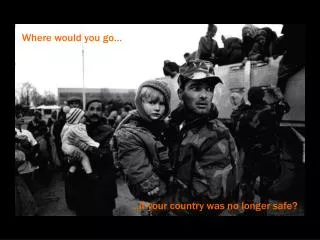
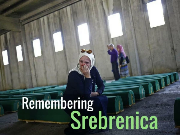
Camber Corporation Provides Arc/Info Support to Bosnian Peace Talks. Background and Introduction. Most recent conflict began in June, 1991 51%-49% territorial split agreed upon September 8, 1995 Cease-fire deal signed October 10, 1995

E N D
Camber Corporation ProvidesArc/Info Support to Bosnian Peace Talks
Background and Introduction • Most recent conflict began in June, 1991 • 51%-49% territorial split agreed upon September 8, 1995 • Cease-fire deal signed October 10, 1995 • Proximity Peace Talks at Wright-Patterson AFB near Dayton, OH began November 1, 1995 • DMA heads up mapping team to support the talks • Camber is called upon to provide Arc/Info support and arrive at the talks on November 10, 1995.
The Mapping Team • The mapping team, under the direction of MG Philip Nuber, • Director, Defense Mapping Agency, included: • Defense Mapping Agency, including personnel from Defense Mapping School (Map Production and Distribution) • Topographic Engineering Center (Engineering and Arc/Info Support) • Cambridge Research (PowerScene) • 3M (Remote Replication System) • Camber Corporation (Arc/Info Support)
Defining the Line The Inter Entity Border (IEB), the line defining the territorial split, had to be finalized before peace could be reached. • The Initial Definition of the IEB Involved: • The October 10 Cease Fire Line • The Bosnian-Croat Federation’s Proposed Line • The Serbian Republic’s Proposed Line • The Contact Group’s Line • (The Contact Group was made up of British, French, German, and Russian Negotiators.) Beginning with these four lines, a final IEB would be established on the 1:600,000 scale UN road map. The next step would be to transfer this line to the 1:50,000 scale DMA topographic line maps.
Camber’s Role • Learn file structure and help define new file naming scheme • Streamline the process used to digitize new lines and calculate resulting percentages • Generate and edit buffers representing zones of separation • Import/export lines from/to PowerScene • Develop standard procedures for processing lines received from PowerScene • Digitize proposed trade-offs, roads and other miscellaneous lines • Design and generate point coverage representing proposed UN Force Basing Areas • Calculate territorial percentages based on new lines
Workspace and Coverage Names Needed to Include: An Indication of the Line Being Represented An Indication of the Revision of the Line Being Represented The directory and file naming scheme chosen included: directories for given days (i.e., a directory named 12Nov contained coverages created between 0000 and 2359 on November 12) a 3-letter code for the line being represented (i.e., CFL in the coverage name indicated a coverage representing the cease fire line) a time/date stamp (i.e., 0215 in a coverage name implies that the coverage was created at 2:15 a.m.) File Structure
Sample File Structure Bosnia 12Nov 13Nov Approved Master Directory Workspaces Coverages and Text Files FED0215 FED0215.txt FED2230 FED2230.txt SRB0430 SRB0430.txt SRB0915 SRB0915.txt LGC1506 LGC1506.txt FED0430 FED0430.txt FED2200 FED2200.txt SRB0940 SRB0940.txt SRB1820 SRB1820.txt LGC0215 LGC0215.txt CFL IEB ZOS INTBND
Before Improvement Lines were being drawn on paper copies of the 1:600,000 UN road map. The map was then affixed to the digitizer, registration tics chosen, and the line digitized. AfterImprovement Master set of “tics” were chosen to be used every time. Transparent film was affixed to the map, the “tics” marked and the line drawn on the film. A copy of the paper map was “permanently” taped to the digitizer and registered in ArcEdit. The film containing the new line was registered to the map on the digitizer and the line digitized. Improved Digitizing Process
1 2 1 Percentage Calculation The calculation of territorial percentages involved: • Digitizing the proposed line • Merging it with the country border (from 1:50,000 scale source) • Editing the digitized work and building polygon topology • Coding the polygons • Calculating the percentage of land area occupied by each entity Polygons were coded with an integer value for use in the percentage calculation AML. Sample Output of Percent AML &r percent Enter cover name: bosnia Record NUM FREQUENCY SUM-PERCENT 1 1 3 51.551010 2 2 1 48.448990
Proximity Peace Talks November, 1995 International Boundary Inter Entity Boundary (as of Nov. 21, 1995) 49% Bosnian-Croat Federation Serbian Republic Bosnia - Herzegovina 51% This map is a representation of the line dividing the Bosnian-Croat Federation and the Serbian Republic as it was agreed upon November 21, 1995. The line maintains the 51% - 49% territorial split that was agreed upon on September 8, 1995 in Geneva. Camber Corporation, 1996
Transferring to the 1:50,000 Scale TLMs “Fly” the Line In Powerscene Making Adjustments On a Single TLM Transfer Adjusted Line to Arc/Info Continues until all TLMs have been “flown” Transfer Line Back To Powerscene After Several TLMs Have Been “Flown” Edit and Code Polygons & Calculate Percentages for Each Sheet
Miscellaneous Tasks • Generate and edit buffers representing zones of separation (ZOS) • Digitize proposed trade-offs, roads, and other miscellaneous lines for analysis • Design and generate point coverages representing proposed UN Force Basing Areas
Conclusions and Lessons Learned • Minor adjustments are still being made to the lines that came out of Dayton • A total of 54 TLMs were affected by the new lines • GIS and 3D visualization were complementary technologies that proved well suited to peace negotiations • Digital mapping was critical to the success of the peace negotiations • Participants from various agencies and corporations melded to form an efficient mapping team • Never underestimate the value of experience