Download
1 / 15
150 likes | 250 Views
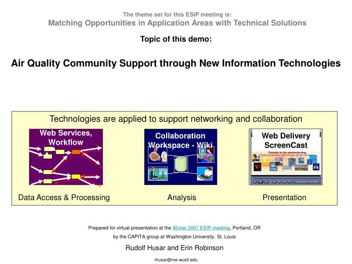
Collaboration Workspace - Wiki. The theme set for this ESIP meeting is: Matching Opportunities in Application Areas with Technical Solutions. Topic of this demo: Air Quality Community Support through New Information Technologies.

E N D
Collaboration Workspace - Wiki The theme set for this ESIP meeting is: Matching Opportunities in Application Areas with Technical Solutions Topic of this demo: Air Quality Community Support through New Information Technologies Technologies are applied to support networking and collaboration Web Services, Workflow Web Delivery ScreenCast Data Access & Processing Analysis Presentation Prepared for virtual presentation at the Winter 2007 ESIP meeting, Portland, OR by the CAPITA group at Washington University, St. Louis Rudolf Husar and Erin Robinson rhusar@me.wustl.edu
Near Future: Mediated Networking EPA AIRNow NASA Giovanni NOAA HazMap WashU DataFed User Node: Local & mediated data access Processing for apps needs Delivers info to user Process Process Process Process Mediator Node: Homogenizes data access Identifies AQ datasets Adds processing services Provider Node: Collects data from the org. Provides catalog of holdings Exposes data on Portal rhusar@me.wustl.edu
Desired State: Peer-to-Peer Networking EPA AIRNow NASA Giovanni NOAA HazMap WashU DataFed User Node: Local & mediated data access Processing for apps needs Delivers info to user Process Process Process Process Standard Interface: Homogenizes data access Provider Node: Collects data from the org. Provides catalog of holdings Exposes data on Portal rhusar@me.wustl.edu
GEOSS PM research NAS, CAAAC CASAC, OMB NOAA EPA PHASE Eco-informatics NASA CDC Programs Risk/exposure assessments Organizations Private Sector AQ forecasting NPS States/Tribes RPO’s/Interstate NAAQS setting Accountability/ indicators USDA SIPs, nat.rules designations NARSTO DOE Enviros Academia NADP Satellite data IMPROVE, NCore PM monit, PAMS Intensive studies PM centers Data sources Supersites CASTNET Health/mort. records Other networks: SEARCH, IADN.. Lidar systems CMAQ GEOS-CHEM Emissions Meteorology Entities participating in AQ information exchannge Unfortunately, the inner working of the IS that links these entities is not yet understood. The challenge posed by R. Scheffe: Please explain this Informatics Mess rhusar@me.wustl.edu
1. Can we integrate air quality information through partnerships? 2. Is data sharing a viable approach to achieve the convergence & optimization? Client Data Overlaps Common data Monitoring Modeling Satellite Specific AQ Informatics Questions: rhusar@me.wustl.edu
Wiki - Collaborative workspace for virtual workgroups • - We use wikis to organize a diverse arrAY of artifacts for a workgroup or a project. See the ESIP wiki or the DataFed or the DataFed wiki • - Wikis (e.g. Wikipedia) are best known for collaborative writing. We have written papers and workgrop reports, even proposals on wikies. • - The discussion pages attached to each wiki page is an easy and way to provide feedback or to conduct disscyssion • - Wiki pages have tags which allow filtering and aggregation through dynamic page lists • - Wikies can be mashed with other web applications such as del.icio.us (social bookmarking), Flickr (picture shaing) and Google Maps using direct links or RSS messaging protocols. rhusar@me.wustl.edu
Characteristics of System of Systems (SoS) • Autonomous constituents managed/operated independently • Independent evolution of each constituent • Displays emergent behavior Must recognize, manage, exploit the characteristics: • No stakeholder has complete SoS insight • Central control is limited; distributed control is essential • Users, must be involved throughout the life of a SoS rhusar@me.wustl.edu
ISO 19123 grid coverage model • ISO 19111 Non uniform vertical dimension • ISO 19139 • ISO TS 19139 is designed to provide a common XML specification for describing, validating and exchanging geographic metadata. It is intended to promote interoperability, and exploit ISO 19115’s advantages in a concrete implementation specification. • ISO 19115 An International Metadata Standard for Geographic Information ( http://www.iso.org/iso/en/CatalogueDetailPage.CatalogueDetail?CSNUMBER=26020&ICS1=35&ICS2=240&ICS3=70 ) established by TC 211 on Geographic Information/ Geomatics rhusar@me.wustl.edu
WMO Information System (WIS) • The WMO Information System (WIS) is an overarching approach and a single coordinated global infrastructure for the collection, distribution, retrieval of, and access to data and information of all WMO and related programmes. rhusar@me.wustl.edu
GADS Workshop Purpose • Bring together experts in atmospheric aerosols and database management to • assess the current state of the art, and to • make recommendations for developing a coordinated plan for future work in aerosol data management aspects of the International Global Aerosol Program (IGAP) Approach • Prior to the meeting, participants were asked to provide written responses to: • current state of knowledge • knowledge gaps, and • recommendations for future work. rhusar@me.wustl.edu
Trends • Surface Obs –> Models, Remote sensing –> Integrated Model & Observations • Rigid Programs (IGAP) –> Dynamic Constellations –> Mashing Programs/Projects • Stove pipes (shops) –> Firm Network –> System of Systems rhusar@me.wustl.edu
Global Aerosol Data System Schematics (WMO GAW, TD 73, 1990) rhusar@me.wustl.edu
A principal raw material or commodity that is in steady demand. Examples flour, rice, or corn. • A basic or principal element or feature. • The fiber of cotton, wool, or flax, graded as to length and fineness. rhusar@me.wustl.edu
Integrated Data System for Air Quality-IDAQ Providers Federate Data Explore Data Understand Info Needs Emission Surface Satellite Model Single Datasets • The challenge is to design a general supportive infrastructure • The ‘cubed’ data can be accessed and explored by slicing-dicing tools rhusar@me.wustl.edu