Download
1 / 42
420 likes | 434 Views
This brainstorming outline discusses the current status of the High-Resolution Rapid Refresh (HRRR) model and its potential enhancements, including radar QC, data assimilation techniques, nesting, and model design issues. It also mentions the planned NCEP operation of meso- and storm-scale models, as well as future developments such as a 1km HRRRE model and the addition of chemistry.

E N D
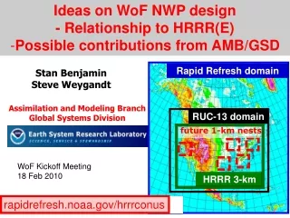
Ideas on WoF NWP design • - Relationship to HRRR(E) • Possible contributions from AMB/GSD Rapid Refresh domain Stan Benjamin Steve Weygandt Assimilation and Modeling Branch Global Systems Division RUC-13 domain future 1-km nests WoF Kickoff Meeting 18 Feb 2010 HRRR 3-km rapidrefresh.noaa.gov/hrrrconus
WoF/HRRR/brain dump Outline - • Current HRRR status • HRRR / RR HRRRE / NARRE superHRRRE • Radar QC • hybcloud – satellite, bird, refl only • Data assimilation • DFI, EnKF, hybrid • Nesting • WRF (and other) model design issues • physics
WoF/HRRR/brain dump Outline - • Current HRRR status • HRRR / RR HRRRE / NARRE superHRRRE • Radar QC • hybcloud – satellite, bird, refl only • Data assimilation • DFI, EnKF, hybrid • Nesting • WRF (and other) model design issues • physics
RUC / RR hourly updating Use latest observations to obtain the freshest analysis and forecasts for aviation, severe weather, energy, and general forecast applications Data types used Rawinsonde (balloons) Wind Profilers (405 MHz, 915 MHz) RASS virtual temperatures VAD winds (WSR-88D radars) Aircraft (ACARS, TAMDAR) Surface (METAR , Buoy, Mesonet Precipitable water (GPS, GOES, SSM/I) GOES cloud-drift winds GOES cloud-top pressure/temp Radar reflectivity, lightning Ship reports/dropsondes Satellite radiances (Rapid Refresh) 1-hr fcst 1-hr fcst 1-hr fcst Back- ground Fields Analysis Fields 3DVAR 3DVAR Obs Obs Time (UTC) 11 12 13
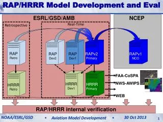
RUC RR Radar Assim Hourly updating model RUC / RR and HRRR models Data Assimilation cycle HRRR Observations
00z+6h HRRR No radar 00z+6h HRRR RUC radar NSSL verification RUC radar assimilation on 13-km grid improves HRRR 3-km forecast 06z 16 Aug 2007
3km HRRR verification-From NCAR report- 16 Dec 2009 “Model Performance and Sensitivity”(Mei Xu, David Dowell, Jenny Sun) RUC grids provided much improved initial condition for HRRR than NAM or GFS grids, especially in 1-6h RUC-based HRRR skill (even without radar assimilation) due to effective analysis of convective environment using other observations (ACARS, profiler, surface, cloud obs)and digital filter initialization (focuses vertical motion for convection)
3km HRRR verification- From NCAR report- 16 Dec 2009 “Model Performance and Sensitivity”(Mei Xu, David Dowell, Jenny Sun) RUC grids provided much improved initial condition for HRRR than NAM or GFS grids, especially in 1-6h Addition of radar assimilation to RUC convective environment adds further improvement for first ~6h (representative example from individual case from late July 2009)
WoF/HRRR/brain dump Outline - • Current HRRR status • HRRR / RR HRRRE / NARRE superHRRRE • Radar QC • hybcloud – satellite, bird, refl only • Data assimilation • DFI, EnKF, hybrid • Nesting • WRF (and other) model design issues • physics
Planned NCEP Operation Meso- and Storm-scale models • NAM • NEMS based NMM • Bgrid replaces Egrid • Parent remains at 12 km • Multiple Nests Run to 48hr • ~4 km CONUS nest • ~6 km Alaska nest • ~3 km HI & PR nests,and/or a~1.5-2km DHS/FireWeather/IMET are possible 2010-2011 • Rapid Refresh • WRF-based ARW • NCEP’s GSI analysis (RR-version) • Expanded 13 km Domain to include Alaska • Experimental 3 km HRRR @ ESRL WRF-Rapid Refresh domain – 2010 RUC-13 CONUS domain Original CONUS domain Experimental 3 km HRRR 11 11
Rapid Refresh Partial Cycling GFS model GFS model RR spin-up cycle RR spin-up cycle Observation assimilation 00z 03z 06z 09z 12z 15z 18z 21z 00z Observation assimilation RR Hourly cycling throughout the day - Hourly cycling of land surface model fields - 6 hour spin-up cycle for hydrometeors, surface fields
Planned Operational Meso- and Storm-scale Ensembles 2012-2013 • NAM/Rapid Refresh ENSEMBLE – NRRE • Initially ~6 member ensemble made up of equal numbers of NMMB- & ARW-based configurations • Hourly updated with forecasts to 24 hours • High Res Rapid Refresh ENSEMBLE – HRRRE • Nest HRRRE ensemble within NRRE • Opportunities to: • Provide improved probability guidance for hazardous wx • Use for Nextgen, Warn-on-Forecast, sensible wx
Outline - Configuration DA #mem Current 3km HRRR RUC-DFI )13km 1 Spring 2010 “ RR-DFI +HRRR-DFI (3km) + Conv Init (GOES) ~Fall 2010 3km-HRRR+1km subnests +15min full output (hubs, RE site(s)?) Spring 2011 RR – add chem 2011? 3kmHRRR+1km-nest +chem Late 2011 NARRE-6 member (~13km) (RR-EnKF in testing? -OU-Xuguang/AMB
Outline - Configuration DA #mem 2012-testing 3km HRRR EnKF(?) / NARRE 1 Next HRRRE (6x CPU) 6 Add 1km HRRR (27x 3km HRRR) (grow 1km nest inside 3km HRRR as CPU becomes available, similar) Our dream so far (but not yet WoF dream) 2015-18? 1km HRRRE-chem Hybrid EnKF/4dvar/DFI? + 300m fixed nests (for avx, RE) ~30 = “SuperHRRRE” (15-30min update frequency)
Data assimilation ideas • Current – 3dvar, then 13kmDFI • Next – add 3km DFI • Next – incorporate DFI within 3dvar outer loop • EnKF@13-20km, then 13km/3km DFI • - may be significant improvement for mesoscale environment • - initial work in FY10 under FAA (Ming Xue, Xuguang Wang w/ RR, RRgroup • Hybrid EnKF/3dvar @13km, then 13km/3km DFI • Hybrid @3km. (Does 3km DFI still add?)
HRRR Domain(s) September 2007 Initial HRRR domain over the northeastern United States “aviation corridor” 745 x 383 grid points, 200 processors March 2009 Domain expanded to cover approximately eastern 2/3 of the US 1000 x 700 grid points, 568 processors October 2009 Domain expanded to cover CONUS 1800 x 1060 grid points, 840 processors RUC Domain HRRR 2010 HRRR 2009 HRRR 2008 Hourly frequency maintained
WoF/HRRR/brain dump Outline - • Current HRRR status • HRRR / RR HRRRE / NARRE superHRRRE • Radar QC • hybcloud – satellite, bird, refl only • Data assimilation • DFI, EnKF, hybrid • Nesting • WRF (and other) model design issues • physics
Crude radar refl QC in RUC (and RR) - • Start with NSSL QC • Comparison with GOES satellite (clear satellite results in radar clearing) • Water vapor moistening (reduction of subsaturation) applied • PW comparisons with GPS and RUC led to discovery of bird contamination • Complaints from Seth Gutman – “Dr. GPS-PW” • Reflectivity vs. temperature condition developed • 3-d Reflectivity < 28 dBz not used at night if Temp > 4°C
Crude radar refl QC in RUC (and RR) - • Start with NSSL QC • Comparison with GOES satellite (clear satellite results in radar clearing) • Water vapor moistening (reduction of subsaturation) applied • PW comparisons with GPS and RUC led to discovery of bird contamination • Complaints from Seth Gutman – “Dr. GPS-PW” QC working well in general, glitch in early Aug? Typical season variation, radar contribution to poorer fit but no regrets…
WoF/HRRR/brain dump Outline - • Current HRRR status • HRRR / RR HRRRE / NARRE superHRRRE • Radar QC • hybcloud – satellite, bird, refl only • Data assimilation • DFI, EnKF, hybrid • Nesting • WRF (and other) model design issues • physics
Radar reflectivity assimilation Digital Filter-based reflectivity assimilation initializes ongoing precipitation regions -30 min -15 min Initial +15 min + 30 min Backwards integration, no physics Forward integration,full physics with radar-based latent heating Initial fields with improved balance, storm-scale circulation RUC / RR HRRR model forecast + RUC/RR Convection suppression – ask us about it…
Rapid Refresh (GSI + ARW) reflectivity assimilation example Upper-level Divergence Low-level Convergence NSSL radar reflectivity (dBZ) K=17 U-comp. diff (radar - norad) K=4 U-comp. diff (radar - norad) 14z 22 Oct 2008 Z = 3 km
RUC RR Radar Assim Hourly updating model RUC / RR and HRRR models Data Assimilation cycle HRRR Observations
RUC RR Radar Assim Hourly updating model RUC / RR and HRRR models Data Assimilation cycle 2nd pass 3-km radar DFI analysis HRRR Observations
HRRR with radar DA only on 3-km domain 18z Radar 17 June 2009 RUC NO HRRR RAD hydrometeor + 0h fcsts RUC NO HRRR NO RUC NO HRRR radar
HRRR with radar DA only on 3-km domain 19z Radar 17 June 2009 RUC NO HRRR RAD hydrometeor + 1h fcsts RUC NO HRRR NO RUC NO HRRR radar
HRRR with radar DA only on 3-km domain 20z Radar 17 June 2009 RUC NO HRRR RAD hydrometeor + 2h fcsts RUC NO HRRR NO RUC NO HRRR radar
HRRR with radar DA only on 3-km domain 21z Radar 17 June 2009 RUC NO HRRR RAD hydrometeor 20z Radar + 3h fcsts RUC NO HRRR NO RUC NO HRRR radar
WoF/HRRR/brain dump Outline - • Current HRRR status • HRRR / RR HRRRE / NARRE superHRRRE • Radar QC • hybcloud – satellite, bird, refl only • Data assimilation • DFI, EnKF, hybrid • Nesting • WRF (and other) model design issues • physics
WoF/HRRR nesting ideas - • Possibilities • WoF (HRRR dx/3) - 1-way nest in small domain • Re-initialize WoF over multi-state subset of HRRR domain at HRRR-dx • 2-way nests to HRRR-dx/3 (and beyond)
WoF/HRRR nesting ideas - • Possibilities • WoF (HRRR dx/3) - 1-way nest in small domain • Re-initialize WoF over multi-state subset of HRRR domain at HRRR-dx • 2-way nests to HRRR-dx/3 (and beyond) • WoF domain • du jour • WoF dx • Outer = HRRRdx • Inner = HRRR/3 • ……
WoF/HRRR/brain dump Outline - • Current HRRR status • HRRR / RR HRRRE / NARRE superHRRRE • Radar QC • hybcloud – satellite, bird, refl only • Data assimilation • DFI, EnKF, hybrid • Nesting • WRF (and other) model design issues • physics • microphysics, PBL, radiation, LSM, LES at ≤500m resolution, chemistry
NCAR-Thompson Microphysics RUC uses Dec 2003 version of scheme Version in WRF v3.1 (mp_physics = 8) has many changes - 2-moment (mixing ratio and number concentration) rain helps better simulate difference in drop-size distribution between rain resulting from melting snow and that from collision-coalescence of cloud drops - Greater ice supersaturation allowed (up to water saturation) - Snow particles assumed to be more 2-d than spherical (affects deposition, collision and fall speed) - Revised collection of snow and graupel by rain - Extensive use of lookup tables - Option for Gamma distribution for all precip hydrometeors Subjective impressions for RR: Less graupel, more cloud ice and snow than in RUC version
WRF-Chem and RR Primary WRF-Chem development and coordination occurring in GSD (Georg, Steven, Mariusz) Next few years: introduce simple version of WRF-Chem into the RR (or even HRRR) as a first step towardintegrated operational weather--air quality forecasting - Aerosol direct effect on radiation (e.g. solar direct-beam irradiance, surface temp forecasts) - Improved warm-rain and ice nucleation in microphysics (aerosol indirect effects) for better cloud/precip forecasts (impact on ceiling, visibility, icing, surface temp) - First step: RR-Chem put together by Steven and Tanya * Once per day to 48h * Aerosol cycling only
(HRRR-Chem Vertically Integrated Small Aerosol Concentration(relative units)1200 UTC 2 Sep 2009 Sources are primarily wildfires, biggest in San Gabriel Mtns, southern CA
Alternative PBL schemes available in WRF-ARW: YSU MYNN QNSE • 2.5 level closure; similar to MYJ in neutral-unstable conditions, but in stable conditions, QNSE scheme is activated. • Turbulent eddies and waves are treated as one entity in the stable regime. • Similar physics as MYJ, but enhanced treatment of stable nocturnal boundary layer. • First-order bulk scheme. • Includes a countergradient term to parameterize nonlocal mixing. • Explicit entrainment which is proportional to surface buoyancy fluxes. • Stronger vertical mixing may alleviate the bias found in the MYJ. • 2.5 and 3.0 level closure. • The master length scale is a function of 3 independent length scale (turbulent, surface layer, and stable layer). • Updated stability functions • Condensation Module. • Similar physics as MYJ, but tuned to LES simulations for more aggressive vertical mixing.
PBL Scheme Testing • New candidate PBL schemes need to show skill across RR domain and reduce biases compared with MYJ. Given recent interest in the RR (and HRRR) for wind energy applications, low-level jets and coastal jet cases are good tests for the new PBL schemes. LLJ case(s) of 20070818-19 WRF-ARW Configuration (v3.1.1): 13.2 and 3.3 km grid spacing 51 vertical levels RUC LSM Grell-3 Cumulus Scheme Thompson Microphysics Scheme RRTM LW Radiation, Dudhia SW radiation MYJ/MYNN/QNSE/YSU PBL Initial Conditions: GFS 6-hourly analyses (Actual RR configuration covers all of North America)
Vertical cross-section @ 09Z 20070819 • QNSE produces the strongest and widest LLJ. • YSU has the weakest and most vertically diffuse LLJ. • Of the 3 TKE-based schemes, the MYNN has stronger vertical mixing, with the jet top ~100 m higher than MYJ or QNSE. • Strength of daytime vertical mixing is similar in rank, but has more variation (not shown). MYJ QNSE Temperature MYNN YSU Wind Speed
Convective probability forecasts from HRRR time-lagged ensemble (shown with deterministic fcst) Reflectivity (dBZ) Probability (%) 21z 16 July ‘09 Verification 15z + 6h HRRR and HCPF
3km HRRR verification- From NCAR report- 16 Dec 2009 “Model Performance and Sensitivity”(Mei Xu, David Dowell, Jenny Sun) RUC grids provided much improved initial condition for HRRR than NAM or GFS grids, especially in 1-6h Addition of radar assimilation to RUC convective environment adds further improvement for first ~6h (representative example from individual case from late July 2009)
WoF/HRRR Areas of AMB contribution- • HRRR / RR HRRRE / NARRE superHRRRE • Radar QC • hybcloud – satellite, bird, refl only • Data assimilation • DFI, EnKF, hybrid • (mesoscale DA in addition to stormscale) • Nesting • WRF (and other) model design issues • physics • microphysics, PBL, radiation, LSM, LES at ≤500m resolution, chemistry