Download

1 / 26
260 likes | 277 Views
This article explores the various characteristics of sea level records, including measurements, tides, non-tidal changes, mean sea level, and long-term trends. It also discusses the importance of tidal analysis and its applications in producing tide tables and identifying non-tidal signals.

E N D
Characteristics of Sea Level Records Philip L. Woodworth Permanent Service for Mean Sea Level With thanks to Simon Williams
Definitions: • The expression ‘sea level’ means different things to different people. • Sea Level for us means: • The height of the sea measured relative to a mark on the nearby land called the Tide Gauge Benchmark
Sea levels measured by tide gauges at the Newlyn Lighthouse tidal observatory are measured relative to the TGBM in the floor of the building
Sea Level Measurements • Sea level is measured by a tide gauge • Values of sea level (or sea surface height) are either spot-measurements at regular time intervals, or averages (called integrations) over the time intervals. • For most tidal, storm surge or Mean Sea Level work, time intervals of 5, 6, or 15 minutes are adequate. • For tsunami work, time intervals of a minute or less are usually needed.
A Sea Level Record will show: • The ocean tide • On timescales of minutes to hours, there could be signals due to seiches or tsunamis • On timescales of hours to days, there could be signals due to storm surges • On longer timescales, there could be seasonal and longer changes and even, at the longest timescales, signals due to climate change
Tides • Periodic movements which are directly related in amplitude and phase to some periodic geophysical force • The dominant geophysical forcing function is the variation of the gravitational field on the surface of the earth, caused by regular movements of the moon-earth and earth-sun systems.
Tidal signals in March 1981 at five sites which have very different tidal regimes Karumba : diurnal Musay’id : mixed Kilindini : semidiurnal Bermuda : semidiurnal Courtown : shallow sea distortion Lunar characteristics responsible for these tidal patterns
Frequency distribution of hourly tidal levels Newlyn, semidiurnal Karumba, diurnal
The Tide To learn about tides – read chapters 2-5 of David Pugh’s book
Main Points about the Tide to make here: • Tidal characteristics at any location can be determined well from a year of good tide gauge data • The knowledge obtained can be used to produce Tables of Predicted Tide Levels (‘Tide Tables’) for local use • Tidal and Non-tidal components of the sea level record can be separated easily using Harmonic Tidal Analysis of a tide gauge data set.
Non-Tidal Changes • Storm surges caused by changes in air pressure and winds • Seiches due to resonant behavior of harbours and bays (caused by many things, often wind) • Seasonal, interannual changes due to changes in water density • Tsunami caused by earthquakes • And many more non-tidal sources.
Mean Sea Level • Daily MSL is calculated by applying a suitable filter (see IOC Manual III for details) to the measured tide gauge data (i.e. not the tidal or non-tidal parts separately, but the measured values) • Monthly MSL is then defined as the arithmetic average of the daily MSL values in that month • Annual MSL is defined as the average of the daily MSL values in a year
Typical analysis of monthly mean sea levels Periodic tidal terms (nodal, annual and semi-annual) Long term mean and trend residuals Meteorological effects
Permanent Service for Mean Sea Level • Time series of MSL are collected by the PSMSL • Long records show signals due to seasonal processes, El Nino, and sea and land level changes • One goal in ODINAFRICA is to eventually have long records of MSL from more African stations
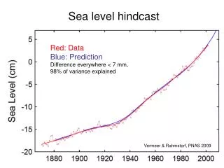
Sea Level Changes in Last 100 Years • Past 100 years • Most PSMSL records show evidence for rising sea levels during the past century • IPCC Third Assessment Report concluded that there has been a global rise of approximately 10-20 cm during the past 100 years
Types of Sea Level Records • Real-time. Data are often transmitted to a warning centre which can look out for flooding due to storm surges or tsunamis. Delay (latency) has to be as short as possible so there is no time for detailed inspection of the record • Delayed Mode. Delay is not a major issue. Data are archived by a centre for subsequent detailed analysis and removal of errors. Such highest-quality data are needed for scientific research, for production of a range of products (e.g. tide tables), for computation of MSL etc. • There are almost 2 different communities of people involved: Operational agencies, Scientists/Engineers
Why do we care about tidal analysis if we just want to provide real-time data and monthly MSL (neither of which require tidal analysis in theory)? • Two main reasons: • The separation of the sea level record into tidal and non-tidal components is needed if one needs to produce tide tables or tidal predictions • The non-tidal signals (seiches, tsunamis) become clearly identified • Tidal analysis also enables errors in the sea level time series to be identified highest-quality data for subsequent analysis
How does a tidal analysis work? • The tide is parameterised in terms of harmonics with periods specified by the orbits of the Moon and Sun but with unknown amplitudes and phase i.e. Tide The unknown parameters are Z0 and the (Hj, gj). The fitting is adjusted so that the sum of the squares of the difference between the observed and computed tidal levels is minimized. The residuals to the fit are considered to be the ‘non-tidal’ terms
An example – maybe not the best but one I had available – from Port Stanley Nov-Dec 2004 Measured Tide
Non-tidal In the non-tidal record: 1. Variations of a few days, amplitude of a few cm (this is southern summer so no big storm surges) 2. A lot of high-frequency noise of a few cm due to harbour seiches 3. On 27 December arrival of the Sumatra tsunami (15 cm or so) None of this is evident from looking at the total measured record.
The non-tidal component is often called the Residual (or sometimes the ‘tidal residual’). • It will be immediately clear (especially with some experience) by looking at the residuals if there is: • A spike or jump in the data due to instrumental faults • A timing error due to a section of data being given the wrong time • And many other errors see the IOC Manuals • These errors can then be fixed in the data set. The final data set is called the Quality Controlled Delayed-Mode data set.
Such tidal analysis can be undertaken using one of the software packages available for the GLOSS and ODINAFRICA programmes, see http://www.pol.ac.uk/psmsl/training In this course we will be using the TIDE TASKS FOR WINDOWS package.