Download
1 / 1
10 likes | 171 Views
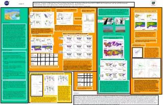
Vancouver Island. Dust. Asian Dust storm. Cold front. SeaWifs image, 7 April. SeaWifs image, 11 April. Navajo Mountain, Page, AZ typical view 16 April 2001.

E N D
Vancouver Island Dust Asian Dust storm Cold front SeaWifs image, 7 April SeaWifs image, 11 April Navajo Mountain, Page, AZ typical view 16 April 2001 Transpacific Transport of Mineral Dust from Asia During Spring 2001: Evaluation of Results from GEOS-CHEM with Ground-based, and Aircraft Measurements. T. Duncan Fairlie#*, Daniel J. Jacob*, Rokjin J. Park*, #NASA Langley Research Center, *Harvard University Contact information: Duncan Fairlie (M.S. 401B, NASA Langley Research Center, t.d.fairlie@larc.nasa.gov, 757-864-5818), A31B-07 April 2001 saw a major transpacific transport of Asian dust that strongly impacted air quality at many western and some eastern IMPROVE sites. The dust plume was observed by satellite (e.g. SeaWifs), and measurements were made of its arrival in North America during the PHOBEA II project. Measurements of dust outflow from Asia were made during the ACE-Asia airborne campaign. Comparison of model with IMPROVE observations Dust source functions for GOCART and DEAD schemes in April 2001 IMPROVE PM2.5 vs Model, Bandelier, NM, 2001 Model Dust Emissions and Columns, April 2001 GOCART scheme Sample timeseries At Bandelier NM Bandelier DEAD GOCART Introduction DEAD April Mineral dust is the single largest contributor to atmospheric aerosol. Dust is mobilized during strong wind events over arid soils. Airborne dust contributes to the scattering and absorption of solar radiation, its deposition contributes minerals to the ocean and terrestrial biosphere. High aerosol loadings have important consequences for human and animal health. There is clear evidence from satellites (e.g. Seawifs, TOMS) that mineral dust is transported to North America from source regions overseas. Yet, the impact of such trans-ocean transport remains poorly quantified. Global simulations of mineral dust are conducted for 2001 using the GEOS-CHEM tropospheric chemistry and aerosol transport model. The simulations are focused on determining the contribution of overseas sources on aerosol concentrations over North America. In particular, what is the impact of Asian dust? The role of changing vegetation cover and human activity in dust mobilization remains a topic of much debate. We conduct separate simulations with two different contemporary dust mobilization schemes that take opposing sides of this debate to address this issue. • IMPROVE aerosol network: focuses on visibility in Fed. 1 sites • data for aerosol sulfate, nitrate, ammonium, elemental carbon (EC), • organic carbon (OC), fine and coarse dust, sea salt. • Fine dust (PM2.5) = 2.2*Al+2.49*Si+1.63*Ca+2.42*Fe+1.94*Ti • (Malm et al., 1994). Source: http://vista.cira.colostate.edu/improve The source function, S, represents the geographic distribution of potential emission, modulated by an efficiency factor. For GOCART, S is time invariant; for DEAD, S varies with vegetation cover which is seasonally varying. mg/m2 mg/m2 Both mobilization schemes represent dust emissions over the Gobi and Taklimakan deserts in western China and Mongolia. The DEAD scheme also represents emissions in devegetated regions (e.g. Manchuria). Model vs. data percentiles at IMPROVE sites for 2001 GEOS-CHEM 2001 annual emissions and annual mean dust burdens 20th 50th 80th Modeled Asian dust event, April 16, 2001, using DEAD scheme IMPROVE data Comparison with TAS bulk aerosol dust from ACE-Asia April, 2001. surface GOCART DEAD Emission (Tons km-2 yr-1) G-C with DEAD C130 flights for ACE- Asia, April 2001 [Huebert et al.] In-situ bulk aerosol measurements made by U. Hawaii (TAS) (Huebert et al.) during ACE-Asia. Dust mass diagnosed from Ca2+ and Na+ measurements. Account for sea salt-Ca2+ contribution (ss-Ca2+ = 0.0439 ss-Na+ neq., Wilson, 1975). Assume Ca2+ = 6.8% dust by mass (Wang, 1999; Song and Carmichael, 2001), following Jordan et al. [2004]. mg/m3 column Model description Burden (mg m-2) G-C with GOCART • GEOS-CHEM chemistry and aerosol transport model: • [e.g. Fiore et al., 2003; Park et al., 2003]. • 2o x 2.5o horizontal resolution, 48 sigma levels. • 6-h NASA (GEOS) assimilated met. fields: winds, temperatures, convective mass fluxes, surface properties for 2001. • Dry deposition – gravitational settling [Seinfeld and Pandis, 1998], turbulent transfer, impaction, interception [Zhang et al. 2001]. • Wet deposition – rainout, washout, resuspension, convective, stratiform, convective anvils, cirrus precipitation. [Liu et al., 2001]. • Dust mobilization schemes: • (1) Georgia Tech/Goddard Global Ozone Chemistry Aerosol Radiation and Transport (GOCART) model [Ginoux et al., 2001; Chin et al., 2004] • (2) Dust Emission and Deposition (DEAD) model [Zender et al., 2003a]. • Dust Size bins: 0.1-1.0, 1.0-1.8, 1.8-3.0, 3.0-6.0 mm radius mg/m2 Model (DEAD) vs IMPROVE PM2.5 dust on 16 April 2001 GOCART scheme behaves best in eastern US, remote from N. American sources. GOCART sources are too active in the west, where they are active throughout the year, in contrast with observations. The DEAD scheme performs better in western US, where its sources are weaker than in GOCART, but the simulation is compromised by excessive mobilization over the northern plains and western locations in Spring and Fall, resulting from seasonal minima in vegetation (LAI). Prairie lands are vulnerable to wind-borne soil erosion, but land management techniques, including strip farming, seeding, and tree belts, help mitigate this process (source: G. Luciuk, M. Black, Ag, & Agr-Food, Canada). G-C with DEAD IMPROVE Budget quantities are approx. half with DEAD as those with GOCART mg/m3 mg/m3 G-C with DEAD, no N.A. emissions Comparison with climatologies from U. Miami surface network G-C with GOCART mg/m3 mg/m3 These panels illustrate the model’s ability to represent dust outflow from the Asian coast, observed by the TAS instrument during ACE-Asia. The simulation that uses the DEAD scheme fares best: the ratio of median dust simulated to median observed dust is 0.82 (0.55 for GOCART), although the simulation explains only 25% of the variance in the data. Simulations with both schemes underestimate boundary layer values, although DEAD represents emissions from devegetated lands (e.g. in Manchuria) that Chin et al. [2004] found important in resolving BL differences. [Data source: Huebert et al., U. Hawaii] These panels compare model simulations with the 2 mobilization schemes vs. IMPROVE data on 16 April. Each simulation explains approx. 40% of the variance in the IMPROVE data on this day. The bottom right panel shows a simulation with the DEAD scheme where North American dust emissions are eliminated. This simulation finds that overseas (principally Asian) sources account for between 83 and 100% of fine dust surface values at western US sites on April 16. Beyond this extreme event, our analysis indicates that overseas dust contributes 0.1 mg/m3 or more (28-98%) to monthly mean fine dust at the surface at both western and eastern sites from March through November 2001. The GOCART scheme considers dust mobilization to occur exclusively in vegetation-free, arid desert regions. The scheme uses a time-invariant source function with an efficiency factor that enhances mobilization in topographic depressions, e.g., ephemeral lakes, and dry river beds. The design is based on TOMS aerosol observations [Prospero et al., 2002]. The DEAD scheme does not restrict dust mobilization to desert areas, but permits changing vegetation ( leaf area index, LAI, diagnosed from AVHRR data) and snow cover to affect mobilization potential. An efficiency factor, proportional to upstream runoff area, is recommended [Zender et al., 2003b]. Both schemes inhibit mobilization with surface wetness. Ratios of median monthly-mean values show where the model overestimates/ underestimates climatological values. Both schemes show higher outflow from North Africa for 2001 than climatology. Neither scheme captures the Saharan influence in SE CONUS, due to a small displacement in the plume. Southern hemisphere values are generally underestimated. Data courtesy: D. Savoie, J. Prospero. Mean values at IMPROVE locations for each percentile level Summary Global mineral dust simulations have been conducted for 2001 using two contemporary dust mobilization schemes, and compared with ground-based measurements from the IMPROVE aerosol network over North America, and from the global U. Miami network. The simulation that uses the DEAD scheme provides better comparisons with IMPROVE observations, particularly in western states, where dust sources using the GOCART scheme are found to be too intense and long-lived. On the other hand, DEAD suffers from occasional excessive local emissions in areas characterized by seasonally low vegetation cover, e.g. northern prairies. Satellite measurements of leaf area index (LAI), used to constrain dust emission, are insensitive to senescent vegetation and land management practices which help mitigate wind-blown soil erosion. LAI measurements alone appear to be insufficient to account for the vegetative impact on dust mobilization. Simulations with both schemes capture the seasonal cycle and background levels over the northern Pacific and western Atlantic, as found in U. Miami surface climatologies. Both simulations capture the impact of the major Asian dust event of April 2001 on North America. A simulation that eliminates North American emissions indicates that over 80% of surface fine dust values at western sites in mid April are due to transpacific sources. Beyond this extreme event, our analysis indicates that overseas dust contributes 0.1 mg/m3 or more (28-98%) to monthly mean fine dust at the surface at both western and eastern sites from March through November 2001. Both schemes show some skill in simulating outflow of mineral dust from the Asian source region, as measured during ACE-Asia airborne campaign, although boundary layer values are underestimated. Both simulations capture the seasonal variation over the North Pacific (e.g. Midway) and west North Atlantic. Background levels are well represented. Values obtained with the GOCART scheme during dusty seasons are about twice those obtained with the DEAD scheme, which are closer to observed values.