Download
1 / 11
110 likes | 227 Views
The 2013 NG-CHC Annual Meeting presented advanced methodologies for validating geospatial information to improve model grid development in the Northern Gulf of Mexico. This initiative involved creating high-resolution bathymetric dynamic digital elevation models (BDDEMs) utilizing comprehensive data from the National Geophysical Data Center and NOAA bathymetric surveys. Key outcomes include yearly updates at varying resolutions and web access to data via OpenDAP and FTP. This effort aims to enhance understanding and management of coastal hazards in the Northern Gulf.

E N D
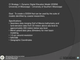
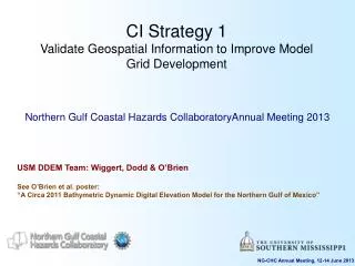
CI Strategy 1Validate Geospatial Information to Improve Model Grid Development Northern Gulf Coastal Hazards CollaboratoryAnnual Meeting 2013 USM DDEM Team: Wiggert, Dodd & O’Brien See O’Brien et al. poster: “A Circa 2011 Bathymetric Dynamic Digital Elevation Model for the Northern Gulf of Mexico” NG-CHC Annual Meeting, 12-14 June 2013
Outline • Stage 1 • Basis: NGDC Coastal Relief Model • Ingest: Regional High Resolution DEMs in the Northern Gulf of Mexico • Outcome: 1/3, 1 and 3 arc-second NGCHC BDDEM • Stage 2 • Ingest: NOS Bathymetric Surveys (2002-2011) for LA/MS/AL Methods examples • Outcome: 1/3, 1 and 3 arc-second yearly updates of the NGCHC BDDEM • Web Access via OpenDAP and FTP • Open Source Software Toolkits NG-CHC Annual Meeting, 29-30 May 2012
Stage 1: CRM + DEMs • The basis for the Stage 1 effort is Volume 4 of the National Geophysical Data Center (NGDC) CRM released in 2001(3 arc-sec) • Stage 1 entailed ingesting all of the NGDC DEMs that were released subsequent to the Volume 4 CRM • These were: • Northern Gulf Coast (1 arcsec) • Biloxi, Mobile, SE Louisiana & New Orleans (1/3 arcsec) • Final Stage 1 build (shown below) is at 1/3 arcsec • Available on DMS THREDDS Server • 1 arcsec and 3 arcsec versions also provided. NG-CHC Annual Meeting, 12-14 June 2013
2008 2009 2005 2011 2004 2007 2010 2002 2003 2006 Stage 2: NOS Surveys by Year • Inventory of NOS surveys available in the LA-MS-AL region was taken (Total of 113 available) • BDDEM updates have been generated for each year • Vertical datum is unified to NAVD88 • Full resolution is 1/3 arcsec (8.4 GB gzipped) • 1 arcsec (1 GB gzipped) and 3 arcsec (190 MB) NOTE: At the Equator, 1 arcsec = 30.87 m NG-CHC Annual Meeting, 12-14 June 2013
Depth (m) Bathymetry Difference (2009 - 2004) • With individually saved years of the Stage 2 build, exploration of the temporal evolution of updated bathymetry is possible • Here, the difference between the 3 arcsec Stage 2 builds for 2009 and 2004 are shown • Upper figure is for the MS-AL region, with a difference range of ± 2 meters • Lower figure is for the LA-MS region, with a difference range of ± 5 meters • Time frame choice is set with objective to highlight the impact of Katrina, Gustav and Ike with benefit of the NOS survey results released in 2009 • NOTE: Difference relative to 2004 does not equate to a bathymetry change over 5-year period (i.e., the depth change is relative to last-performed survey) Red -> Shallower in 2009 Blue -> Deeper in 2009 NG-CHC Annual Meeting, 12-14 June 2013
Web Accessible BDDEM Products • Stage 1 and Stage 2 BDDEM products are available on the DMS THREDDS Server (Parrotfish) and/or the DMS FTP Server (Moray) • The provision of products at varying resolution is done so that if 1/3 arcsec is more than needed, reduced resource downloads can be accommodated • Stage 1 updates at resolutions of 1/3, 1 and 3 arcsec are available at: • http://parrotfish.ssc.usm.edu:8080/thredds/catalog/ParrotfishThreddsData/ngchc/chcBuild/stage1/catalog.html • Stage 2 annual updates at resolutions of 1 and 3 arcsec are available at: • http://parrotfish.ssc.usm.edu:8080/thredds/catalog/ParrotfishThreddsData/ngchc/chcBuild/stage2/catalog.html • Stage 2 annual updates at resolutions of 1/3 arcsec are available via anonymous FTP • Server: moray.dms.usm.edu • File path: NGCHC/bathDDEM/stage2/1_3_Arc NG-CHC Annual Meeting, 29-30 May 2012
Open Source Software Tools • This effort is in progress NG-CHC Annual Meeting, 29-30 May 2012
Extra NG-CHC Annual Meeting, 12-14 June 2013
NGDC High Resolution DEMs in the Northern Gulf of Mexico (NGOM) • Aspects of note: • Data formats are variable • Unify within an updated base elevation model for the NG-CHC DDEM • Inconsistent Datums • Vertical Datums should be unified • Ascertain observational basis • DEMs are constructed from NOS, USACE and OCS data sets • Identify whether the higher resolution DEMs are constructed through informed interpolation • Is higher resolution data supporting these higher resolution DEM products? NG-CHC Annual Meeting, 12-14 June 2013
Bathymetric Surveys in AL, MS Waters 2001-2010 Surveys Highlighted in Magenta (15 Single Beam, 15 Multibeam) NG-CHC Annual Meeting, 12-14 June 2013
Bathymetric Surveys in LA Waters 2001-2010 Surveys Highlighted in Magenta (10 Single Beam, 41 Multibeam) NG-CHC Annual Meeting, 12-14 June 2013