Target Vision and Implementation Plan for CGDI
510 likes | 656 Views
Information Interoperability Institute ( III ) Ottawa June 14, 2000. Target Vision and Implementation Plan for CGDI. Contents. High-level visioning for CGDI The III team approach Needs, context and components Strategic framework and analysis Multi-stage vision for CGDI

Target Vision and Implementation Plan for CGDI
E N D
Presentation Transcript
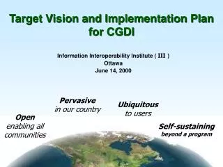
Information Interoperability Institute ( III ) Ottawa June 14, 2000 Target Vision and Implementation Plan for CGDI
Contents • High-level visioning for CGDI • The III team approach • Needs, context and components • Strategic framework and analysis • Multi-stage vision for CGDI • Architectures: from now to CGDI • Implementation priorities • Conclusions Slide 2 of 52
Contents • High-level visioning for CGDI • The III team approach • Needs, context and components • Strategic framework and analysis • Multi-stage vision for CGDI • Architectures: from now to CGDI • Implementation priorities • Conclusions Slide 3 of 52
High-level visioning for CGDI “ Vision is the art of seeing things invisible.” Jonathan Swift (1667-1745) “ The only thing worth finding is that which has not yet existed.” Pierre Teilhard de Chardin (1881-1955) Slide 4 of 52
High-level visioning for CGDI • The infrastructure paradox: • for those using it: it must be transparent, simple to use, and offer products and services that meet their needs; • for those building and maintaining it: it is a complex system of technology, people and processes, and it must continuously evolve according to user needs, w/o breaking. Slide 5 of 52
We are here Degree of Ease of Use Increasing Complexity of hidden technology High-level visioning for CGDI Evolution of a successful infrastructure Slide 6 of 52
High-level visioning for CGDI • A vision for CGDI: • “ a national geospatial information infrastructure that is pervasive throughout our country, ubiquitous to its users and self-sustaining, in support of the betterment of Canada's health, social, cultural, economic and natural resource heritage and futures.” • To be all of this - CGDI must be the best in the world! Slide 7 of 52
High-level visioning for CGDI • Building CGDI: • will require a large investment for several years; • must follow a stable and clear vision; • must be based on a sustainable architecture (standards-based, open); • will spawn a new Canadian industry, competitive internationally. Slide 8 of 52
Contents • High-level visioning for CGDI • The III team approach • Needs, context and components • Strategic framework and analysis • Multi-stage vision for CGDI • Architectures: from now to CGDI • Implementation priorities • Conclusions Slide 9 of 52
The III team approach • Develop a high-level generic vision that can withstand time; • Develop a vision that is holistic, enabling integration of CGDI with other infrastructures; • Develop a vision that goes beyond a technical system vision, to encompass organizations and policies; • Develop an architecture concept that is open, interoperable, and supports a network of geospatial services. Slide 10 of 52
The III team approach • Understand the business drivers; • Review a variety of existing initiatives; • Validate common requirements; • Develop a Vision; • Define an architecture concept; • Provide a strategy for implementation; • Recommend tactical steps for deployment. Slide 11 of 52
Contents • High-level visioning for CGDI • The III team approach • Needs, context and components • Strategic framework and analysis • Multi-stage vision for CGDI • Architectures: from now to CGDI • Implementation priorities • Conclusions Slide 12 of 52
Pesticide Permit Mine Operations Environmental Assessment Act Watersheds Management Waste Permit Water Licenses Lakes Database Ecosystem Integrity X Fish Stock Releases Rare & Endangered Species Hatchery Mgt X X X Petroleum Exploration Fisheries Coastal Zone Management Shipping of products Needs, context and components Forest Tenures X X X Fisheries Stream class A (biophysical habitat WETLAND) Slide 13 of 52
Production testing Export Applications Environmental Assessment Engineering Historical Research Reservoir Testing Refining Marketing Data Synthesis Providing Delivery Infrastructure Production Exploration Drilling Seismic Profiling Land & Permit Acquisition Partnerships Consumer Needs, context and components Slide 14 of 52
Needs, context and components General challenges w/i the geospatial realm • Diversity reigns in: • operating systems, platforms, interfaces, and applications; • functionality of applications, overlaps; • particular needs of organizational interfaces; • … leading to … • increasing costs in building systems; • increasing difficulty to operate & support applications; • increasing risk of failure; … cont’d Slide 15 of 52
Needs, context and components General Problems w/i the geospatial realm (cont’d) … Diversity reigns ... • … leaving us facing important challenges … • establish common understanding among stakeholders; • define future user needs and matching requirements; • integrate a large diversity of components. Slide 16 of 52
Needs, context and components Initiatives impacting CGDI • Natural Resources Information Interoperability Initiative • DND Spatial Data Warehouse & GEONet • CEONet • Canadian Hydrographic Service • GEOIDE • BC Ministry of Environment, Lands & Parks, Land Data BC • Information Interoperability Institute • Land Info Ontario LIO • Marine Geospatial Data Infrastructure … cont’d Slide 17 of 52
Needs, context and components Initiatives impacting CGDI (cont’d) • Geologic Survey of Canada Knowledge Initiative, GeoSpatial Warehouse and Data Model Initiative • OGC initiatives (WMT-1, WMT-2, USL) • CEOS • Digital Earth • DND / NIMA ACTD • JSP (Joint Space Program) • CASA (Common Architecture for Situational Awareness) • etc. Slide 18 of 52
Framework information Stakeholder Information Endangered species Seismic surveys Facilities information Marine habitat Geological mapping Climatology Shipping & Aeronautical Topographic base Survey and GPS Hydrographic Charts Land disposition (leases, tenures, water licences, etc.) Administrative areas Satellite imagery Tide and Current Foundation information Spatial, Temporal, and Administration Reference e.g., Geodetic control, Seamless Hydrographic Datum Needs,context and components Slide 19 of 52
Needs,context and components Stakeholder communities to be analyzed: • Transportation • Marine community • Defence • Disaster management • Forestry • Agriculture • Petroleum, mines and minerals • Public health and emergency services • Utilities and public works • Telecommunications • Public sector • Financial and business sector • Not-for-profits and NGO’s • Academic Slide 20 of 52
Needs,context and components Analysis of stakeholder communities: • Illustrating the diversity of requirements • Investigating infrastructure type initiatives • Key parameters to be considered: • target applications and clientele • data holdings • data discovery • data access and intellectual property • architecture • standards followed • degree of client satisfaction Slide 21 of 52
Contents • High-level visioning for CGDI • The III team approach • Needs, context and components • Strategic framework and analysis • Multi-stage vision for CGDI • Architectures: from now to CGDI • Implementation priorities • Conclusions Slide 22 of 52
Government Policy & Training Research and Development Demonstrations & Testbeds Core Integration Requirements & Info Design Information Mgmnt & Dissemination Information Applications Information Production Industry Research Strategic framework and analysis CGDI is about partnerships Slide 23 of 52
Stovepipes Connectivity Inter- Connectivity Inter- Operability Client-server Data tran sfer Data sharing Enterprise-wide single database and within broad system and data applications warehousing subject areas integration Implementation continuum Application Enterprise view view Strategic framework and analysis The goal: interoperability Now! Year 2 Year 5 Slide 24 of 52
Evolution of CGDI Strategic framework and analysis The goal: well beyond data Wisdom Knowledge Information Data [ The real world ] Slide 25 of 52
Strategic framework and analysis Positioning of stakeholders in the strategic framework • Research initiatives: GEOIDE • Developers of components / specifications: DND Spatial Warehouse OGC (USL, WMT) CEONet CEOS CHS I I I • Early adopters: BC Ministry of Environment NIMA GSC CASA Health Canada MGDI • Users:not properly represented yet !!! Slide 26 of 52
Strategic framework and analysis • III , the Information Interoperability Institute: • OGDI open source maintenance and evolution • Interoperability Canadian Consortium • Interoperability Technology Demonstrator • Interoperability specifications development and conformance testing • Business consortium of Canadian enterprises Slide 27 of 52
Contents • High-level visioning for CGDI • The III team approach • Needs, context and components • Strategic framework and analysis • Multi-stage vision for CGDI • Architectures: from now to CGDI • Implementation priorities • Conclusions Slide 28 of 52
The Sound Architectural Framework:The Components of the RM-ODP( ISO/IEC 10746: Open Distributed Process’g - Reference Model) Slide 29 of 52
Why Use RM -ODP ?It is an effective framework and …… it is accepted! • The RM-ODP is endorsed and used by: • The US Digital Earth Initiative • The Mercator Alliance • The Open GIS Consortium • The ISO TC211 Geomatic and Geographic Information Standards Committee • The Object Management Group • Many Canadian Government Agencies • Many US Government Agencies • Many private sector consulting firms Slide 30 of 52
The RM -ODP Viewpoints in a business context ENTERPRISE VIEWPOINT direction and constraint on STRATEGIC VISION BUSINESS VIEWPOINT PLANNING VIEWPOINT POLICY AND governed by FRAMEWORK VIEWPOINT DEVELOPMENT VIEWPOINT specifies structure for CONTENT SYSTEMS direction and constraint on VIEWPOINT ENGINEERING VIEWPOINT structured by WORKFLOW METHODS OPERATIONS VIEWPOINT VIEWPOINT INFORMATION TECHNOLOGY VIEWPOINT VIEWPOINT COMPUTATIONAL VIEWPOINT governed by Based on ISO/IEC 10746: Open Distributed Processing - Reference Model Slide 31 of 52
Multi-stage vision for CGDI Slide 33 of 52
Geospatial services targeted for the short-term (2yrs) • Data server • Catalog server • Map server • Portrayal server • Registry server • Viewer client • Publisher client • Editor client • Discovery client Slide 34 of 52
Geospatial services targeted for the short-term (2yrs) Service interfaces Slide 35 of 52
Contents • High-level visioning for CGDI • The III team approach • Needs, context and components • Strategic framework and analysis • Multi-stage vision for CGDI • Architectures: from now to CGDI • Implementation priorities • Conclusions Slide 36 of 52
DATA SHOPPING OPTIONS OPERATIONAL & EXTERNAL DATABASES OR FILES LOCAL DATA WAREHOUSE MASTER DATA WAREHOUSE LOCAL DATA WAREHOUSE LOCAL DATA WAREHOUSE TOOLS & APPLICATIONS DATA VIEWS Now: Spatial Warehousing Services Slide 37 of 52
Galdos GML Style Sheet Editor Symbol Library Social Change Online Client Style Sheet Now:USL Web Mapping Testbed Viewer Client (Dynamic Portal) Viewer Client (ArcView) Services Registry SVG Renderer WMS 1.0 Picture Servers WMS 1.0 Picture Servers IONIC GML Portrayal Service Style Sheet Catalog MIT - Landsat, etc NASA - Digital Earth FGDC - NRCS - DRG Social Change - Accuweather IONIC - Enviromapper IONIC - Stream Guage SAIC - ArcIMS (with lots of layers) CubeWerx - lots of layers GML Data “Schemas” (DTD) CubeWerx GML Data Server Slide 38 of 52
Now: Natural Resources Information Interoperability Initiative A vision for CGDI ... … pervasive in our country, … ubiquitous to its users, … self-sustaining. Slide 39 of 52
Now:the Defence Geomatics Gateway Slide 40 of 52
Short-term (2 years) architecture for CGDI Slide 42 of 52
GIS & applications Integration Tools Tools for modeling, cleaning, integrating and loading data. Access Tools Tools for query, analysis and reporting. Tier 3 Application Environments Tier 2 Application Servers DB servers File servers App Servers Data Access Protocols & APIs Network Interface APIs File manager Meta-Data Management (Repository) Tier 1 Data Management & Data Server Environment Data files Data Management Tools Object-Relational DBMS & Spatial Enhancements A common multi-tierarchitecture of existing components Slide 41 of 52
INCEPTION ELABORATION CONSTRUCTION TRANSITION User-Level Use Cases High-Level Package Diagrams Development-Level Use Cases Class Diagrams Class Implementation and Integration Tech Demonstrator Build and Test Time Line Short-term (2 years) architecture for CGDI(Controlled Iteration Process) Slide 43 of 52
Short-term (2 years) architecture for CGDI Advanced Concept Technology Demonstrator (ACTD) properties: • Networked and distributed, • Centralized coordination, • Indicates maturity of infrastructure, • Marketing vehicle for standards-based, open technology, • Conformance testing vehicle. Slide 44 of 52
Contents • High-level visioning for CGDI • The III team approach • Needs, context and components • Strategic framework and analysis • Multi-stage vision for CGDI • Architectures: from now to CGDI • Implementation priorities • Conclusions Slide 45 of 52
STRUCTURED GeoConnections DISCUSSIONS SYSTEM ARCHITECTURE Business Processes Information Flows & Relationships Systems & Applications Data Descriptions Technology Infrastructure Implementation priorities A collaborative environment to support a collective effort STAKEHOLDER TOPICS SYSTEM REQUIREMENTS • Issues & Concerns • Issues & Concerns • Operational requirements • Information Needs • Operational requirements • Information Needs • Command & Communication • Functional requirements • Command & Communication • Functional requirements • Performance requirements • Operational Concepts • Performance requirements • Operational Concepts • Interoperability requirements • System/application concepts • Interoperability requirements • System/application concepts • Life-cycle support requirements • Lessons learned • Life-cycle support requirements • Lessons learned • Emerging requirements • Emerging requirements • Incremental capabilities • Incremental capabilities • ……. • ……. Slide 46 of 52
Implementation priorities First steps in implementing the Vision: • Verify the roles of partners and components • Priorize the goals • Establish a time table and obtain required resources • Use off-the-shelf tools as much as possible • Use standards as a guide: ISO, OGC and W3C (and see how they are evolving) • Look beyond spatial to other, next-generation, technology (e.g. mobile solutions) = forward synergy • Establish close liaisons with organizations moving in the same direction and/or providing support in that same direction (LIO, CGKN, PGGQ, ISTA, DERM, NIMA etc) Slide 47 of 52
Implementation priorities “Only two things are simple on Earth: tell what happened in the past, and predict the future. To see clearly one day at a time is quite a different undertaking.” Armand Salacrou (1899-1989) Slide 48 of 52
Implementation priorities CGDI sustainability parameters: • Architecture maintenance and update • Organizational sustainability (2-5-10 yrs) • Standards: • on-going conformance testing • intercultural adaptability • Policies for sustainability: • information access and diffusion • information commercialization • Financial sustainability (2-5-10 yrs) • Business plan Slide 49 of 52
Contents • High-level visioning for CGDI • The III team approach • Needs, context and components • Strategic framework and analysis • Multi-stage vision for CGDI • Architectures: from now to CGDI • Implementation priorities • Conclusions Slide 50 of 52
Conclusions • TheIII team is well positioned to develop an integrated vision and architecture for CGDI, and to provide a key focus in the building of CGDI; • Embrace broad coverage: beyond data, towards information, leading to user knowledge/wisdom; • Focus on infrastructure NOT systems; • Become stakeholder driven (not technology ~ ); • Stakeholders must eventually manage and control the architecture; • Several domestic benefits: much reduced costs, high efficiency, emergence of a new industry; • International positioning: a model for export. Slide 51 of 52