Download
1 / 29
290 likes | 388 Views
Discover cutting-edge geothermal exploration methods involving reservoir engineering, geophysics, and isotope geochemistry. Learn about seismic imaging, electromagnetic mapping, and reservoir modeling for efficient resource identification and monitoring.

E N D
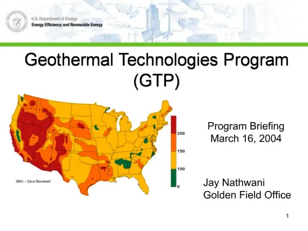
DOE GeothermalProgram Briefing March 20, 2003 Earth Sciences Division Lawrence Berkeley National Laboratory Mack Kennedy
Geothermal Energy ProgramLawrence Berkeley National Laboratory • Mission: Develop and integrate state of the art scientific methods to assist industry in finding, characterizing, and producing geothermal fields. • Core Strengths • Reservoir Engineering • Geophysics (Seismic, EM, MT, Remote Sensing) • Isotope Geochemistry • Rock Mechanics • Geology
Lawrence Berkeley National Laboratory • Programmatic Goals Addressed by LBNL’s Geothermal Program • Resource Expansion • Advance fundamental understanding of geothermal systems • Advance reservoir characterization technologies • Resource assessment • Exploration • Evaluate and develop new innovative techniques • Reduce drilling costs – improved well-siting
Lawrence Berkeley National Laboratory • Collaborations • Industry: Calpine; Caithness; Unocal; Exxon-Mobil; CalEnergy; EMI; EPDC, Japan • Government: USGS; LLNL; SNL; INEEL • Academic: EGI, Univ. of Utah; Univ. of Nevada, Reno; UC Berkeley; Stanford; New Mexico Tech.; Ohio State Univ.; Southern Methodist Univ. • Accomplishments • Publications in Refereed Journals (2001 – Present) -- 25 • Conference Abstracts/Presentations (2001 – Present) -- 25
Lawrence Berkeley National Laboratory • Research Programs • Geothermal Reservoir Dynamics ($375K) • Geophysical Methods for Resource Exploration and Monitoring ($265K) • Innovative Geothermal Exploration Techniques ($260K)
Lawrence Berkeley National Laboratory • Geothermal Reservoir Dynamics • Reservoir Modeling ($195K, K. Pruess) • Isotope and Geochemical Studies ($100K, M. Kennedy, M. Lippman, with A. Truesdell) • Technical Programmatic Assistance ($80K, M. Kennedy, M. Lippmann)
Geothermal Reservoir Dynamics • Reservoir Modeling • Objective: Enhance and apply reservoir simulation codes • Multi-phase fluid and heat flow • Rock-fluid interaction, including mineral precipitation, dissolution, and rock mechanics • Behavior of phase partitioning tracers in geothermal systems.
Reservoir Modeling • TOUGHREACT • TOUGH2 coupled to a fully-featured reaction path code and thermodynamic database • Multiphase fluid and heat flow, plus rock-water-gas chemistry • TOUGH-FLAC • TOUGH2 coupled to commercial rock mechanics code FLAC3D • Non-isothermal stress-strain analysis, with porosity and permeability change • Movement along faults and fractures • Uplift due to episodes of magmatic activity and degassing • Injection response, growth of EGS reservoir • TOUGH2/EOSN • Fluid property module for noble gases and saline brines (including non-saline water) • Realistic temperature dependence of noble gas solubility and diffusivities • Design and analysis of tracer tests (natural or introduced) • TOUGH2 SYMPOSIUM • May 12-14, 2003
Fluid Flow and Diffusion in Fractured-Porous Medium • The lighter noble gases • Partition more strongly into the gas (vapor) phase • Have larger diffusivity • Have stronger diffusive exchange with the rock matrix • As a consequence, the lighter noble gases have… • Slower peak arrival • Reduced peak concentrations • Stronger tails
A Measure of Fracture Spacing Increased fracture spacing... • reduces fracture-matrix interaction • accelerates peak arrival • increases peak concentrations • accelerates decay of tail
Geothermal Reservoir Dynamics • Isotope and Geochemical Studies • Objective: Baseline isotope and geochemical data sets in preparation for monitoring injection to enhance production. • NW Geysers (Aidlin and Ottoboni Ridge) • Coso EGS Project • Technical Programmatic Assistance
Geophysical Methods for Resource Exploration and Monitoring • Seismic Imaging ($175K, E. Majer) • Electromagnetic Imaging ($30K, K-H. Lee) • Integrated Seismic and EM Imaging ($30K, E. Majer, K-H. Lee) • Geodetic Imaging ($30K, D. Vasco)
Program Goals Detection & Mapping of Fluid Paths Work Objectives Adaptation and Application of Modern 3-D Seismic Imaging for Reservoir Definition Work Scope 3-D Seismic Field Data Acquisition State-of-the-Art Data Processing 3-D Numerical Modeling Integrated Seismic with other Geophysical Field Data Accomplishments Seismic Studies at Rye Patch Completed Numerical Modeling of Fractured Reservoir Initiated for Field Design Shot No. 2 3-D Seismic Imaging of Geothermal Reservoirs Model Data Fracture Events
Geophysical Methods for Resource Exploration and Monitoring • Electromagnetic Imaging • Objective: Develop efficient numerical inversion codes for mapping high-permeability zones using single-hole EM data in 3-D. • Complete inversion codes for analyzing 3-D electrical structures in the vicinity of a borehole • Analyze data acquired with the Geo-BILT (EMI), Dixie Valley field test • Conduct field test in The Geysers.
Geo-BILT System Transmitter Electronics EMI (Schlumberger) • Induction coils: • 3 component inductive source • Two 3-component inductive receivers spaced 2 and 5 meters • Operates at four frequencies: 2, 6, 16 and 42 kHz • Operating conditions: 260 C, 5 km 3-Component Transmitter 3-Component Receiver, 2m 3-Component Receiver, 5m Receiver Electronics
Comparison of 3-D Inversions of Single-hole EM Data Integral equation Resistivity (Ohm-m) Easting Northing ft Finite-difference
Imaging Geothermal Reservoir Dynamics using High Resolution Satellite Observations • Program Goals: • Advance understanding of reservoir dynamics. • Enhance geothermal recovery • Objectives: • Develop techniques and software for imaging of reservoir dynamics • Applications to existing and potential geothermal fields • Budget: • LBNL 30K • LLNL 150K • Organization and Personnel: • Don Vasco (LBNL) – Software development, application to geothermal fields • Bill Foxall (LLNL) - InSAR imaging, interpretation • Charles Wicks (USGS) – InSAR data reduction and processing • Accomplishments: • 2001 – Application to Coso geothermal field, publication in Geophysical Journal • 2002/2003 – Application to Dixie Valley geothermal field
Imaging Geothermal Reservoir Dynamics using High Resolution Satellite Observations Space-borne synthetic aperture radar Image deformation over geothermal reservoir Constrain reservoir dynamics
InnovativeGeothermal Exploration Techniques • Objective: Evaluate and develop new techniques for assessing existing and finding new “hidden” geothermal systems. • Integrated approach calling on core LBNL scientific strengths: reservoir engineering, geophysics, isotope geochemistry, geology, and remote sensing. • Active Projects: • Soil gas signatures of hidden systems ($15K, C. Oldenburg, A. Unger) • Isotope geochemistry ($165K, M. Kennedy) • 3-D magnetotellurics ($30K, M. Hoversten) • Feasibility studies and technical oversight ($50K. M. Kennedy) • e.g. Moderate to high temperature H2 extraction from organics
Soil Gas Signatures of Hidden Geothermal Systems Objective: Use coupled subsurface-surface layer modeling to predict expected locations and strength of maximum surface gas concentrations from a sub-surface source. Model Development: T2CA (TOUGH2, CO2, Air with atmospheric dispersion capability).
Program Goals Detection & Mapping Exploration Reservoir diagnostics Work Objectives Push software & hardware development for fully 3D electrical structure mapping Demonstrate geophysical integration in complex 3D hydrothermal environment Work Scope Field data acquisition 3D numerical modeling Integrated data interpretation Budget (combined LBNL & SNL) $80K 2002 $80K 2003 Organization & personnel LBNL (lead) G. M. Hoversten Planning, survey data interpretation SNL G. A. Newman Massively Parallel modeling USGS Jim Kauahikaua Field support, data interpretation EMI Nestor Cuevas Data acquisition systems, support personnel Accomplishments 2002 40 site MT acquisition 2002 AGU paper Imaging of rift zones and magma conduit to the mantel Demonstrated consistency with seismic and gravity interpretations Demonstrated large scale 3D numerical modeling and inversion Kilauea 3-D MT Imaging Experiment
First Pass 2D Conductivity Structure • Depth & location of Vp/Vs anomaly (Dawson et al.) ties to high conductivity beneath southern Kilauea caldera • high fracturing and/or partial melt • Resistivity image delineates melt zones in rift system • Temperature distribution can be inferred from conductivity • Program demonstrates that high quality 3D imaging can be done in hydrothermal areas in the presence of rough topography and complex structure North
Isotope Geochemistry • Objective: Conservative noble gases as tracers for studying fluid processes and heat and sources in geothermal systems. • Locate and define the extent of hidden geothermal systems – Basin and Range, Cascades • Reassessment of geothermal potential • Sensitive tracers for monitoring injectate • Enhance reservoir simulation models
Dixie Valley – Heat and Fluid Sources DV Reservoir: 0.7-0.8 Ra
Dixie ValleyHelium Abundances and Isotopic Compositions:Evidence for a Single Deep Fluid • System must have at least two fluids: • Young groundwater: F(4He) < 10; R/Ra < 0.4 • Fluid indistinguishable from geothermal production fluids: F(4He) > 150-200; R/Ra > 0.8 • Common deepfluid suggests presence of larger exploitable resource.
Lawrence Berkeley National Laboratory • Future Objectives – Well coordinated integrated collaborative field projects involving Industry, National Laboratories, Universities, and the USGS • Resource Expansion • Reliable high resolution remote fracture mapping • Couple mechanical properties and local stress to stimulated fracture geometries and permeability • Geometry and scale of fluid-rock exchange – thermal and chemical • Improved drilling technologies – smart drilling, high temperature • Exploration • Reassessment of geothermal potential • Improved understanding of geothermal systems – Basin and Range • Ground truth assessment of remote sensing techniques
Geophysical Methods for Resource Exploration and Monitoring • Seismic Imaging • Objective: Extend and adapt multi-component 3-D and 4-D seismic imaging to identify and separate geologic heterogeneity and fracture controlled fluid pathways in geothermal reservoirs. • Develop 3-D models of elastic wave propagation in fractured/heterogeneous reservoirs • Integrate surface and borehole seismic imaging methods and models • Evaluate cost effectiveness of single vs. multi-component and VSP vs. surface seismic imaging methods.
Geophysical Methods for Resource Exploration and Monitoring • Integrated Seismic and EM Imaging • Objective: Integrate seismic and EM imaging technologies for optimum mapping of geothermal reservoirs. • Develop an interactive iterative process using velocity structure, electrical conductivity structure, borehole log, and core analysis for optimum interpretation imaging data. • Geodetic Imaging • Objective: Evaluate and develop techniques using observations of surface deformation to image reservoir dynamics associated with fluid production. • Combine high resolution InSAR, GPS, leveling, and tilt meter observations: Dixie Valley, Coso, and perhaps Long Valley. • Collaborative effort with LLNL