Data Collection
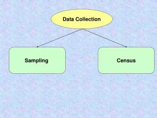
Data Collection. State Well Data (Used on maps to provide drilled information) Kansas – KGS Website Nebraska – NOGCC Website No Password is required just click logon Colorado – COGCC Website Culture Data Tiger Data. Data Collection (cont.).

Data Collection
E N D
Presentation Transcript
Data Collection • State Well Data (Used on maps to provide drilled information) • Kansas – • KGS Website • Nebraska – • NOGCC Website • No Password is required just click logon • Colorado – • COGCC Website • Culture Data • Tiger Data
Data Collection (cont.) • Lot Information – Used during mapping process • Nebraska • Kansas • Colorado • Other resources – BLM GeoCommunicator • Cities • Colorado (CDOT) • Kansas (KDOT) has pdf of other useful information covering Kansas and other States • Nebraska(NDOR) – Georeferenced from county plat book
Collection (cont.) • Lease Information • Internal Mapping Staff • Fields • Provided by Landman • Land Grid • Tobin Land Grid
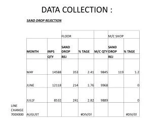
Types of Maps Request • Expiration Map • Mapped leases are queried by Quarter and Year • Noble’s Standards ( Companywide Standard) • Annual Map • Expires 2010, etc. • Quarterly Map • Q 01-10 Expirations • Color Scheme and HBP representation • Held By Production (HBP) • Information gather by Lease Analyst and given a status of developed. Information is exported out as a Excel spreadsheet. • Based on mapped leases the spreadsheet is joined to lease layer.
Types of Map Request (cont.) • Title Opinion and Surface Use Agreement • Spreadsheet given by Land Tech to run through Carteview (program used to run quarter call information) • Map populated based of lawyer name • Rental Obligation and Lease Extensions • Data gathered from Lease Analyst and given in Excel spreadsheet form. • Information is joined to Lease layer to represent.
Creates Map Series (Same Layout) Creates MapBook (collection of Map Series) Title – Overview of Map Series (based of index grid) Creates Map Series ( Multiple Layouts) Title and Series Index ( Glossary after each series) Creates MapBooks Map Series (Collection of pages using one layout) Book Layout (Collection of multiple pages, map series, etc with different layouts) MapBook vs. MapLogics (cont.)
ArcPublisher: ArcReader • ArcPublisher Extension is used to publish maps to be viewed with a desktop application ArcReader. • Limitations: • ArcPublisher with Mapbook and MapLogics • Solution: • My Places • Bookmarks • Limitations • Customization (ArcObjects) • Limitations
Examples • Tristate Maps for Landman • Wattenberg Interactive Platbook