Download
1 / 15
150 likes | 331 Views
CVGSM: The Central Valley Ground and Surfacewater Model. A review of the Hydrology, history, and spatial interpretation. HYDROLOGIC COMPONENTS MODELED IN IGSM. RAINFALL SURFACE RUNOFF INFILTRATION EVAPOTRANSPIRATION MULTI-LAYER GROUNDWATER SIMULATION STREAM-GROUNDWATER INTERACTION

E N D
CVGSM: The Central Valley Ground and Surfacewater Model A review of the Hydrology, history, and spatial interpretation
HYDROLOGIC COMPONENTSMODELED IN IGSM • RAINFALL • SURFACE RUNOFF • INFILTRATION • EVAPOTRANSPIRATION • MULTI-LAYER GROUNDWATER SIMULATION • STREAM-GROUNDWATER INTERACTION • UNSATURATED FLOW
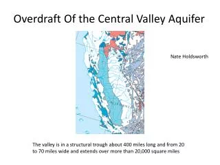
CVGSM BOUNDARY Redding DISTANCE Approx. 650 km N-S Sacramento AVERAGE WIDTH 80 km Bakersfield
CVGSM SUBREGIONS & ELEMENT CONFIGURATION • APPROXIMATELY 20,000 MI2 • 3 AQUIFER LAYERS • 1393 NODAL POINTS • 1392 FINITE ELEMENTS • 21 SUBREGIONS
CVGSM SURFACE WATER SPECIFICATIONS • 72 STREAM REACHES • 121 SMALL WATERSHED INFLOWS • 97 SURFACE WATER DIVERSIONS • 2 LAKES • 8 BYPASS CANALS
Additional maps • Topo Map overlays: • Northern District • Central District • San Joaquin District • Tulare • Diversion Detail: • Northern District • Central District • San Joaquin District • Corcoran Clay Layer • Stream Grid w/ elements
1st Major CVGSM release, 1990 • Data series from 1922 – 1980 • Includes Tulare, San Joaquin, and Sacramento Valley systems • Application created by JMM(now MWH), Boyle Engineering, and govt. help from DWR, and USBR. • Prepared for DWR, USBR, SWRCB, & CCWD
Objectives • Create an application that simulates on a regional scale SW and GW resources of the Central Valley given a comprehensive hydrogeologic database • Adapt DWR/USBR hydrology development process for estimating land use based demands • Produce a “common ground” model that can be used by the public and agencies
Progress through the years… • 1993: San Joaquin hydrology updated to 1990 as part of USBR FRIGSM. No land use updates, but Sacramento precipitation updated. • 1995: USBR contracted to have all data sets updated to 1993 historical. Studies used for CVPIA/PEIS process and as boundary conditions for local applications or other agency models • 2001-Present: DWR updated historical data to 1998 and is currently on steps to verify prior to calibration w/r IGSM2
Current 1998 extension • Completed update of historical time series data (Sept. 2002). Includes land use, flows, deliveries, rainfall, demands. • Documentation is major focal point for re-construction of hydrology to increase public exposure and understanding • Finish upgrading data procedures for extension and verifying records to prepare for internal review of data with constituents
Current 1998 extension • Updated monthly rainfall to daily rainfall to more accurately capture runoff trends • Revisit important data areas for stratigraphy data, evaporation, efficiency values, diversion and canal losses, factors, and static system characteristics • Calibration of CVGSM application of IGSM2 using PEST software
1-2 Year Goals • Update hydrology to reflect ongoing improvements to CALSIM hydrology both in San Joaquin and Sacramento Valleys • Interfacing CVGSM/IGSM2 with a GUI • Database options for input/output data with incorporation to GIS software linkages • Finer mesh discretization and hydrology characteristics in specific regions
1-2 Year Goals • Updating the Tulare Region hydrology and river networks • Land use represented as actual crop distribution per element, rather than uniform distribution of crops over subregion • Potential inclusion of reservoir module with foothill area hydrology