Download
1 / 16
160 likes | 981 Views
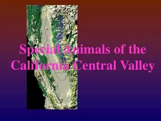
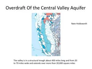
Overdraft Of the Central Valley Aquifer. Nate Holdsworth. The valley is in a structural trough about 400 miles long and from 20 to 70 miles wide and extends over more than 20,000 square miles. 3 regions Redding, Central valley, Tulare separated by different ground water flow systems.

E N D
Overdraft Of the Central Valley Aquifer Nate Holdsworth The valley is in a structural trough about 400 miles long and from 20 to 70 miles wide and extends over more than 20,000 square miles
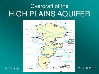
3 regions Redding, Central valley, Tulare separated by different ground water flow systems The most drastic decrease in water levels have taken place in the Tulare Basin and San Joaquin Valley. Sacramento Valley does not pump as much because they have more surface water. Tulare Basin is the deepest part of the aquifer (continental deposit) Also takes the longest to recharge.
Geologic Setting of the Aquifer • THE CENTRAL VALLEY AQUIFER IS A BASIN FILL AQUIFER • THE CENTRAL VALLEY ACTS AS A TROUGH. IT HAS ACCUMULATED CONTINENTAL DEBRIS AND MARINE SEDIMENT OVER MILLIONS OF YEARS AS MOUNTAINS ERODE AND THE VALLEY IS SUBMERGED BENEATH OCEAN WATERS. • OCEAN SEDIMENT DEPOSITED DURING THE LAST INUNDATION OF THE CENTRAL VALLEY DURING THE PALEOCENE(65 MILLION-56.5 MILLION Y.A.) AND EOCENE (56.5-35.4 MILLION Y.A.) IS RELATIVELY IMPERMEABLE. • THE CONTINENTAL MATERIAL(ABOVE OCEAN SEDIMENT) CARRIED INTO THE VALLEY BY MOUNTAIN STREAMS, CONSISTS PRIMARILY OF SAND, GRAVEL, AND CLAY. THIS MATERIAL MAKES UP THE MAJORITY OF THE AQUIFER. • THE AQUIFER VARIES IN DEPTH (CONTINENTAL MATERIAL) FROM 9,000 FT. AT THE DEEPEST. TOWARDS THE SOUTHERN END AND HAS AN AVERAGE THICKNESS OF 2,4OO FT.
Before humans came along and developed the area, the Central Valley Aquifer fully recharged the water table every year in the valley and percolated up into the Sacramento and San Joaquin River’s as well as other small streams and wetland areas that existed throughout the valley.
AGRICULTURE IS A HUGE FACTOR IN AQUIFER DEPLETION “The Central Valley is one of the most important agricultural areas in the world. No single region of comparable size in the United States produces more fruits, vegetables, and nuts. More than 7 million acres are currently (1995) under irrigation. During 1985, crop irrigation accounted for 96 percent of the surface water and 89 percent of the ground water withdrawn in the Central Valley. 8 percent of the U.S. food supply produced in the central valley.”(USGS) California’s Central Valley covers about 20,000 square miles, and is one of the most productive agricultural regions in the world. More than 250 different crops are grown in the Central Valley, with an estimated value of $17 billion per year. Approximately one-sixth of the Nation’s irrigated land is in the Central Valley. About one-fifth of the Nation’s groundwater pumpage is from the Central Valley aquifer system.
Compaction and Land Subsidence as a result of aquifer overdraft “During the period 1961 through 1977, the rate of ground-water withdrawals from the aquifer system was greater than the net recharge from all sources. Withdrawals in excess of recharge resulted in a loss of water from storage in the aquifer of 800,000 acre-feet per year. In the case of the Central Valley aquifer system, some of the loss from storage is permanent because some of the water was removed from beds of fine-grained materials, which, when drained, become compacted and cannot store water again. Compaction of fine-grained materials led to land subsidence in the Central Valley.”(USGS) Drought and decreased availability of surface water have led to increased pumping of the central valley aquifer. Climate change and increased population will likely cause current trends to continue or increase
“The Sacramento Valley is expected to have sufficient supplies to meet agricultural demand until at least 2010. However, without increased surface-water imports, the San Joaquin Valley (exclusive of the Tulare Basin) and the Tulare Basin might require withdrawals of 150,000 and 2,400,000 acre-feet per year, respectively, in excess of recharge. Those estimates probably underestimate additional increased demand that would result from sustained dry weather. Occasional large withdrawals from an aquifer are a viable solution to the problem of reduced surface-water supplies in dry periods, provided the aquifer is replenished during wet years. However, continual withdrawal of ground water in excess of recharge can increase the cost of pumping, reduce water availability, and, in certain hydrogeologic settings, can cause land subsidence.”(USGS) Reverse of groundwater flow because of aquifer overdraft causes rivers and lakes to sink into unconfined aquifers in areas where the water table has been lowered by pumping. Another consequence of aquifer overdraft
CALIFORNIA IS FACING IT’S FOURTH YEAR OF DROUGHT CONDITIONS!!! http://www.water.ca.gov/drought/
Subsidence can cause surface structure damage Over time, but more importantly compaction Decreases the amount of water the aquifer Can hold meaning less water availability In the future, even if the aquifer was fully recharged. When fine-grain groundwater layers of permeable clay, silt, and sand lose water from their pore space they are compacted by the force of the land above and become impermeable. Coarser grain compact as well but can recover, fine grain compaction is usually permanent. The land surface declined nearly 30 feet from the 1920's to the late 1970's in an area southwest of Mendota
SOLUTIONS? More efficient irrigation techniques Artificial recharge of aquifer Education and conservation
sources • http://pubs.usgs.gov/ha/ha730/ch_b/B-text3.html • http://www.alternet.org/water/144676/stealing_water_from_the_future:_california%27s_massive_groundwater_overdraft_newly_revealed • http://articles.sfgate.com/2009-12-15/news/17224129_1_central-valley-water-supply-groundwater • http://pubs.usgs.gov/fs/2009/3057/ • http://www.uwsp.edu/geo/faculty/ritter/geog101/textbook/hydrosphere/subsurface_water_groundwater.html • http://ks.water.usgs.gov/studies/equus/ • http://connect.in.com/california-raisins/photos-1-1-1-2df7bc2408988dbf75fb74c25d6b09eb.html