Mobile GIS for Assessors
Mobile GIS for Assessors. Using ArcGIS Mobile to Create a Field Map for Appraisers and Data Collectors Tyler P. Bragg, GISP Fayette County Assessor’s Office. Overview. Background/Goals ArcGIS Mobile Creating a Mobile Project ArcGIS Mobile Demo Final Setup Challenges

Mobile GIS for Assessors
E N D
Presentation Transcript
Mobile GIS for Assessors Using ArcGIS Mobile to Create a Field Map for Appraisers and Data Collectors Tyler P. Bragg, GISP Fayette County Assessor’s Office
Overview Background/Goals ArcGIS Mobile Creating a Mobile Project ArcGIS Mobile Demo Final Setup Challenges Points of Interest Questions
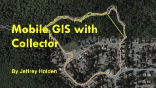
Background/Goals • GIS conversion in 2005 • Subscription-based website since 2007 • Working to fully utilize GIS data throughout Assessor’s Office • Goals for Mobile Project: • Make GIS available in the field to each appraiser/data collector • Make field navigation more efficient and easy, especially in congested areas with many parcels • Leverage GIS data, imagery, and current technology • Create cost-effective field setup that works
ArcGIS Mobile • Basic mapping application that runs on Windows devices • Part of ESRI’s ArcGIS Desktop Suite • 1 “complimentary” ArcGIS Mobile license with each ArcView, ArcEditor, or ArcInfo license • There is cost for additional licenses • Geared toward non-GIS staff • Easy to learn and use • Basic Tasks • Data editing capability
ArcGIS Mobile • Customizable for advanced users • Can be used with/without ArcGIS Server • Fayette County does not have ArcGIS Server • Mobile projects created/exported from ArcMap, then deployed to device • Easy to update • Keep up-to-date with parcel changes • Links with GPS to show real-time location
Creating a Mobile Project • 3 main items installed: • ArcGIS Mobile • Mobile Project Center • Mobile Toolbox • Install ArcGIS Mobile on desktop • Install CD comes with ArcGIS Desktop • Can be downloaded from ESRI website
Creating a Mobile Project • Built from ArcMap document • Set scale dependencies, labels, symbology • Like creating a map for web service – certain symbols/labels/styles don’t work
Creating a Mobile Project • Add “Mobile Tools” toolbox • C:\Program Files\ArcGIS\Mobile10.0\ArcToolbox\Toolboxes • Export map using “Create Mobile Map” tool • Create directory for “Mobile Projects” • Example: C:\Mobile_Projects • Create new folder for each project • Exports a “MobileCache” • Also mobile project file (.amp)
Creating a Mobile Project • Open Mobile Cache in the “Mobile Project Center” • “New” Project • Add Mobile Cache
Creating a Mobile Project • Customization - Layers • Layer viewable by default, searchable, editable, or hidden • For layers to be editable there are additional steps • “View” names of attribute fields • Can choose the ones to be visible by the user
Creating a Mobile Project • Customization – Tasks • Available Tasks: • View Map • Collect Features • Search • View Work List • Manage Edits • Remove unused tasks
Creating a Mobile Project • Save “Windows Mobile Package” • This is the file that ArcGIS Mobile reads • Thumbnail to be seen in mobile application • Save changes • New Title, Tags Description • Thumbnail to be seen in mobile application
Creating a Mobile Project • Open ArcGIS Mobile • No Projects Available • Need to tell ArcGIS Mobile where your project folder is located
Creating a Mobile Project • Click “Change Settings • In “Additional Project Folders, add your project directory • Click OK – project opens
Final Setup • PC • HP Pavilion DM1Z • 11.6” screen • More powerful; lower cost • GPS • GlobalSat BU-353 • Vehicle Mount • Rosewill RMS-A520 • Power Inverter • Rosewill RCI-200MS
Final Setup - Cost • PC $769 • PC Screen Prot. $36 • GPS $37 • Vehicle Mount $72 • Power Inverter $36 • ArcGIS Mobile • (pro-rated per license) $285 $1,235
Challenges • Training • Learning curve for field personnel • Change in workflow • Imagery base • High quality imagery as basemap is difficult • High-resolution imagery too large • Choices limited (SAMB, Pictometry, NAIP) • Customization • Will out-of-the-box work for you?
Points of Interest • This system is not a Tom-Tom • Does not give turn-by-turn directions • Simply a navigational tool • Effectively taking the place of paper tax maps in the field, but better • Gives more confidence to field staff (the GPS shows where they are – no question) • Very cost effective • For less than $1,300 (cost of many laptops) • Can be created and updated in-house by your GIS staff • Can be customized to your specifications • Extensive customization requires programming skills • Can be made as complex as you want – Will work with ArcGIS Server and geo-services
Contact Information Tyler P. Bragg, GISP GIS Specialist Fayette County Assessor’s Office (304) 574-4353 tbragg@assessor.state.wv.us www.fayetteassessor.com