Download
1 / 1
10 likes | 164 Views
A Connected Vehicle-Based Application to Estimate Road Roughness. Huanghui Zeng, Brian L. Smith, Hyungjun Park, Emily Parkany. Background.

E N D
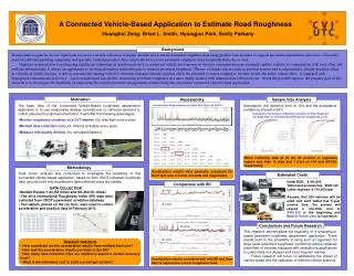
A Connected Vehicle-Based Application to Estimate Road Roughness HuanghuiZeng, Brian L. Smith, Hyungjun Park, Emily Parkany Background Transportation agencies devote significant resources towards collection of highly detailed and accurate pavement roughness data using profiler vans in order to support pavement maintenance decisions. Given the need of calibrated profiling equipment and specially trained personnel, they cannot afford to assess pavement roughness more frequently than once a year. Highway transportation is undergoing significant technological transformations to a connected vehicle environment as wireless communication increasingly enables vehicles to communicate with each other and with the infrastructure. It allows an opportunity to develop alternative methodologies to monitor pavement roughness. The use of simple sensors such as position sensors and accelerometers, already installed either in vehicles or mobile devices, is able to measure the running vehicle’s vibration response directly and thus offers the potential to assess roughness. In other words, the entire vehicle fleet – if equipped with appropriate communication devices – can be transformed into probes, measuring pavement roughness in a more timely manner with minimal data collection cost. Given the possible impacts, the primary goal of this research is to investigate the feasibility of improving the current pavement management systems using this innovative connected vehicle-based application. Motivation Repeatability Sample Size Analysis Assumption: the tolerance error is 10% and the acceptance confidence interval is 95% • The basic idea of the Connected Vehicle-Based roughness assessment application is to use inexpensive devises (smartphone or vehicular sensors) to collect pavement roughness information. It will offer the following advantages: • Monitor roughness condition in a 24/7 manner (Vs. less than once a year) • Minimal data collection cost (Vs. millions of dollars every year) • Measure ride quality directly (Vs. simulated statistic) Acceleration Measurements for Nine Test Runs on I-64 W Cumulative Percentage of Minimum Number of Trips Required for Segments on I-64 and US-250 Based on Roughness Level • When collecting data at 50 Hz, 95 percent of segments require less than 12 trips and 7 trips on I-64 and US-250, respectively. Methodology • Data driven analysis was conducted to investigate the feasibility of this connected vehicle-based application, based on both VDOT-collected roughness data (ground truth) and acceleration data collected using two tablets. • Acceleration results were generally consistent for the 9 test runs in terms of trends and magnitudes. Estimated Costs • Initial R&D: $ 400,000 • Tablet and accessories: $500/veh • Labor expense: $ 150,000/year • Assume that 200 vehicles will be used and each tablet has 5-year service time, the system will require a one-time cost of $400,000 at the beginning and then $170,000 /year for operation. Comparison with IRI • DATA COLLECTION • Studied Routes: I-64 (58 miles) and US-250 (21 miles) • The 2013 International Roughness Index (IRI) data were collected from VDOT’s pavement condition database • Two tablets, placed on the car floor, were used to collect acceleration and position data in February 2013 R = 0.83 CMFs of Good Pavement Conditions vs. Deficient Conditions R = 0.94 Conclusions and Future Research R = 0.71 This research demonstrates the feasibility of a smartphone-based pavement roughness assessment application. These results point to the possibility of using such an approach for large scale pavement roughness monitoring using a relatively small fleet of vehicles equipped with smartphone applications to collect data in a cheaper and more frequent manner. Future research will focus on addressing the impact of vehicle speed and the calibration of different vehicle systems. R = 0.84 • Research Questions • How consistent are the acceleration results from multiple test runs? • How well the acceleration results correlate to the IRI? • How many data collection trips are needed to assure a certain accuracy level? • What is the estimated cost to build a prototype system? • Acceleration results correlated well with IRI and thus able to capture the correct roughness level.