Remote sensing: satellite radar for ocean winds
200 likes | 661 Views
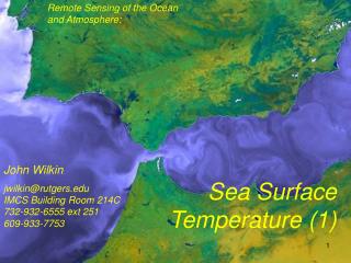
Remote sensing: satellite radar for ocean winds. Charlotte Bay Hasager EWEA Technology Workshop, Brussels 11-11 May 2011. Selected radar satellites (QuikSCAT, Envisat, ASCAT). Physics Ocean surface roughens by wind interaction: Capillary and short gravity waves are generated.

Remote sensing: satellite radar for ocean winds
E N D
Presentation Transcript
Remote sensing: satellite radar for ocean winds Charlotte Bay Hasager EWEA Technology Workshop, Brussels 11-11 May 2011
Physics Ocean surface roughens by wind interaction: Capillary and short gravity waves are generated. More wind causes more steep waves causes higher backscatter. Technical Ocean wind speed (U) is calculated through emperical geophysical model function relating the observed normalized radar cross section (NRCS) with incidence angle (γ) and wind direction (θ). U=f(NRCS, θ, γ)
Accuracy Wind speed < 2 m/s rms error, Wind direction < 20° rms error
Charlotte B. Hasager, Merete Badger, Alfredo Peña, Xiaoli G. Larsén and Ferhat Bingöl Article: SAR-Based Wind Resource Statistics in the Baltic Sea Remote Sens.2011, 3(1), 117-144; doi:10.3390/rs3010117
North Sea study • Høvsøre (coastal) • Horns Rev (offshore) • FINO-1 (offshore) Badger, M., Badger, J., Nielsen, M., Hasager, C.B., Peña, P. (2010) Wind class sampling of satellite SAR imagery for offshore wind resource mapping. J. of Applied Meteorology and Climatology, 49,12, 2474-2491, doi: 10.1175/2010JAMC2523.1
North Sea summary Mean error Mean absolute error U (% ) -1.8 2.2 A (% ) -2.0 2.4 k (%) -3.7 3.7 E -2.3 3.5 (%) • Good overall agreementwith mast observations on the windresource • - within ±5% for the meanwind speed and Weibull A • - within±7% for the power density and Weibull k • The accuracyonwindresourceassessment from mesoscale modeling is typically 10-15%
SAR global view • Risø DTU has experience in • North Sea • Baltic Sea • Irish Sea • Japan • China • India • United Arab Emirates • Mediterranean • Portugal • Iceland • Egypt • Galathea 3 expedition • among more • Others include • Canada • USA • Black Sea • South Korea • Taiwan • among more ESA archive, use EOLI
Northern Seas WRF minus QuikSCAT, 10 yr Conclusions
North Sea German Bight plans Source http://www.4coffshore.com/offshorewind/
U Christiansen, M.B.; Hasager, C.B., Using airborne and satellite SAR for wake mapping offshore. Wind Energy (2006) 9 437-455 Wind field from ERS-2 SAR
Conclusions • Satellite remote sensing provides ocean winds • Long archives 1987 to present (SSM/I, ERS, QuikSCAT, ASCAT, etc.) • Twice daily global coverage (QuikSCAT for 10 yr, 1999-2009) • High spatial resolution (ERS SAR, Envisat ASAR, Radarsat, etc.) • Accuracy relevant for pre-feasibility • Independent data source for evaluation of atmospheric models • OFFSHORE WINDS: state-of-the-art COMBINING satellite and modelling
Acknowledgements Satellite data from: Envisat ASAR from ESA Cat. 1 project 3644 and ESA-CSA SOAR project 6773 QuikSCAT from Remote Sensing Systems ASCAT from EUMETSAT The Johns Hopkins University, Applied Physics Laboratory, USA is thanked for providing and supporting the APL/NOAA SAR Wind Retrieval System (ANSWRS). Other data from: WRF model results from Andrea Hahmann Comparison to WRF from Ioanna Karagali Envisat ASAR analysis from Merete Badger and Ferhat Bingöl Comparison to met data Alfredo Peña Photo of wind farm wake from Vattenfall Met-data from DONG Energy, Vattenfall and BMU. Offshore wind farm map from http://www.4coffshore.com/ Funding from: EU-Norsewind project (TREN-FP7EN-21908) and the EU-South Baltic OFF.E.R (EU European Development Fund and the South Baltic Program