Download
1 / 105
1.07k likes | 1.23k Views
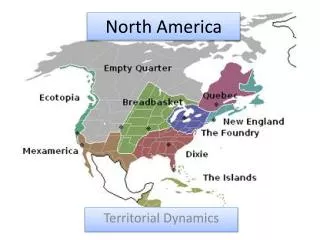
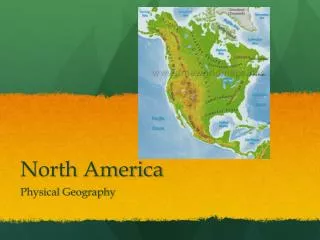
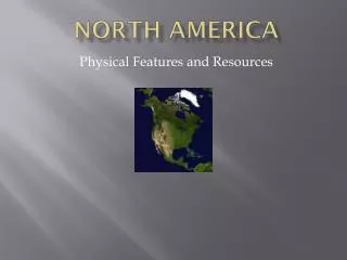
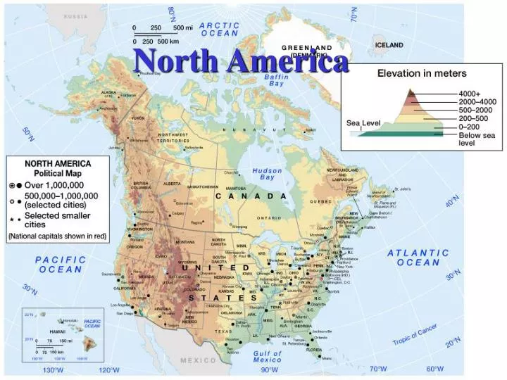
North America. Introduction. U.S. and Canada Highly urbanized and mobile society Culturally diverse Resource-rich environment Postindustrial economy. Environmental Geography. Interior lowland(Great Plains) surrounded by mountainous topography(Rocky, Appalachian).

E N D
Introduction • U.S. and Canada • Highly urbanized and mobile society • Culturally diverse • Resource-rich environment • Postindustrial economy
Interior lowland(Great Plains) surrounded by mountainous topography(Rocky, Appalachian)
Physical setting - East Appalachians and surrounding regions • East/South of Appalachian Highlands • Coastal plains (S.NY to TX): not well drained prone to flood • Southern Appalachian (South PA) • Sedimentary rock rich in coal • Northern Appalachian (North of PA) • Crystalline rock irregular surface form (eg. New England, Canadian Maritimes)
Physical setting - Interior Lowland drained by the Mississippi River and its tributaries Extends from west central Canada to the Gulf of Mexico • Eastward • Southern Great Lakes, Ohio River Valley • Westward • Sediments eroded from the Rocky Mountains • Northward • Glacial forces - North of Ohio and Missouri rivers
Physical setting - West • Rocky Mountains • Extends from Alaska to New Mexico • A series of uplift with 10K ft height • Source of Platte, Rio Grande, Columbia, Colorado river • Denver and Calgary are located here • Great Basins • Nevada, sparsely settled • Pacific Rim • Formed on the convergent plate boundary – North American plate collides with Pacific plate
Majority is the temperate climates except for dry climates in the southwestern part 100th meridian dry humid
Climate and Vegetation - East • South of Great Lakes • Abundant in deciduous (broadleaf) forest, but some are cleared for agriculture • North of Great Lakes • Coniferous (evergreen/boreal) forest • Tundra: mixture of low shrubs, grasses and flowering herbs near Hudson Bay
Climate and Vegetation - East Deciduous in Piedmont Coniferous in Manitoba Subtropical humid climate; Fields of cotton and corn are bordered by mixed oak-pine woodland Subarctic climate; Spindly Conifers of little commercial value; Marshes are common in glaciated environment
Climate and Vegetation - East Tundra in the Northwest Territories Covered with lichens and grass; no tree can be seen
Climate and Vegetation – Great Plains • East of 100th Meridian • Above 20-inch precipitation (subhumid) • Prairie: tall grasslands • West of 100th Meridian • Below 20-inch precipitation (arid) • Short grasses and scrub vegetation
Climate and Vegetation – Great Plains Prairie in the eastern Kansas
Climate and Vegetation – West • Desert (Southeast of Sierra Nevada) • Southern Pacific coast (South of SF) • Mediterranean climates – chaparral scrub • Northern Pacific coast (North of SF) • Marine west coast climates – mixed, coniferous forest • Rocky mountains • Varies by altitude (pine to tundra)
Climate and Vegetation – West Chaparral in Monterey, CA Conifers in Colorado Rockies Found in the foothills of California; dense growth of evergreen shrub Taken at an elevation of 11,000 feet; Conifers gives way to Alpine Tundra at the higher altitude
Climate cycles • Long term • Glacial advance 15,000 years ago north of the Missouri and Ohio rivers (eg. Great Lakes) • Short term • Drought cycles early 1900s on the Great Plains (eg. Dust Bowl era of the 1920s and 1930s)
Natural Hazards • Seismic rigors: earthquakes, tsunamis, volcanoes along the plate boundary in the Western North America • Densely settled coastline: vulnerable to flood, hurricane, rise of the sea level • Wildfire: mountains of western North America
Western Montana, summer 2000 • Global warming, periodic droughts, and growing population may cause this scene to be repeated
Environmental issues – soils and vegetation • Native vegetation has been removed for cropping, grazing, and urbanization • Widespread soil erosion as a result
Environmental issues – water • Distribution of water resources (eg. aqueduct) eg. LA Aqueduct, Central Valley project Colorado River ->agricultural/metropolitan regions in Southern CA • Water shortage eg. Depletion of Ogallala Aquifer beneath the Great Plains • Water contamination • Wastewater, Oil spill, raw sewage, fertilizer/pesticides, salinization
California aqueduct • reconfigures the distribution of water resources • promotes the agricultural and metropolitan expansion
Environmental issues – atmosphere • Local scale • Urban heat islands • Warmer temperature in the metropolitan area than nearby rural areas • Regional scale • Acid rain • Caused by sulfur dioxide & nitrogen oxides in atmosphere • Damage forests, poison lake • Produced in the Midwest, southern Ontario • Affects the Ohio Valley, Appalachia, the northeastern US, eastern Canada
Sparsely populated • Low RNI, TFR • Population aging • High urbanization rate
Spatial pattern of population Densely populated areas are • Canadian urban corridor • Toronto, Ottawa, and Montreal • U.S. • Megalopolis - Washington D.C., Baltimore, Philadelphia, New York, and Boston • Southern Great Lakes, South, Pacific Coast
Population growth • Rapid growth since European colonization (1600~) • Higher rates of immigration in the late 19th and 20th centuries • Birthrates gradually fell after 1900 • “Baby boom” between 1946 and 1965 • Continuing increase in immigration • Projected to 375 million by 2025
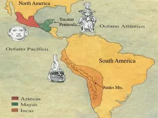
Occupying the Land Precontact period (Native Americans) • Estimated 3.2 million for the Continental US, and 1.3 million for Canada, Alaska, Hawaii, and Greenland (A.D. 1500) European settlement expansion • First stage (1600-1750) – Coastal region of east • Second stage (1750-1850) – eastern half • Third stage (1850-1910) – west
European expansion – First stage • St. Lawrence Valley, Canadian Maritimes - French • Southern New England - English Puritans • New Netherlands (later New York) - Dutch • Pennsylvania - English Quaker • plantation South (Virginia, South Carolina) - Bicultural European, and African • Gulf of Mexico (New Orleans 1718) - French • Southwest (Santa Fe 1610), and Florida (St. Augustine 1565) - Spanish
European expansion – Second stage • Found the interior Lowlands region ideal for agricultural settlement • Midwest and interior South
European expansion – Third stage • Attracted by opportunities in California, the Oregon country, Mormon Utah, and the Great Plains • Mineral rushes in Colorado, Montana, and British Columbia’s Fraser Valley
Migration trend - outlines • Westward-moving populations • Black Exodus from the South • Rural-to-urban migration • Growth of the Sun Belt South • Counterurbanization trend
Westward-moving populations • By 1990 • More than half lived west of Mississippi River • 1990-2000 • Growth of the interior West (Nevada, Arizona, Utah, Montana) • Fueled by new job creation in high-technology industries • Includes many outward-bound Californians
Nevada (66 percent growth) and Arizona (40 percent growth) were the two fastest-growing states between 1990 and 2000
Black Exodus from the South • Black populations were originally concentrated in the plantation South • Industrialization (early 20th centuries) • South North and West • Growth of Sun Belt (after 1970) • North and West South
Rural-to-urban migration • Fueled by industrialization • Urban orientation facilitates processes of modernization and globalization
Growth of the Sun Belt South • After 1970 • Georgia, Florida, Texas, and North Carolina grew more rapidly than states in the Northeast and Midwest • Contributed by • The South’s buoyant economy • Modest living costs • Adoption of air conditioning • Attractive recreational opportunities
Counterurbanization trend • Significant population gains in nonmetropolitan areas • Participants are • Growing retiree population • Lifestyle migrants: prefer small towns that are affordable, amenities-rich, and free of urban problems
The evolution of the city in the U.S. A: pre-1888 B: 1888-1920 C: 1920-1945 D: 1945-present • Changing transportation technologies decisively shaped the evolution of the city • U.S. cities became increasingly decentralized A B C D
Urban decentralization Suburb of Las Vegas 1990 2000
Edge city • Have fewer functional connections with the central city than they have with other suburban centers • Urban settlements grow in area, but decline in density • Rapid loss of surrounding rural land Tysons Corner, Virginia
Challenges in the inner city • As a result of suburbanization, inner cities suffer • Losses in population • Increased levels of crime and social disruption • Shrinking tax base • Racial tension especially in the U.S.
City of Buffalo – Map by census 2000 • Median household income • Black population • White population • Hispanic population
Gentrification • Inner-city revitalization by new public and private investments • Displacement of lower-income residents of central-city neighborhoods with higher-income residents • eg. Seattle’s Pioneer Square, Toronto’s Yorkville district, and Baltimore’s Harborplace