Download
1 / 28
280 likes | 444 Views
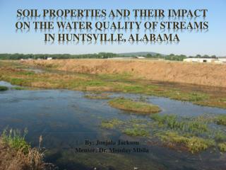
By: Jonjala Jackson Mentor: Dr. Monday Mbila. Soil Properties and Their Impact on the Water Quality of Streams in Huntsville, Alabama. Introduction. One function of soil is to regulate the drainage, flow, and storage of water and solutes

E N D
By: Jonjala Jackson Mentor: Dr. Monday Mbila Soil Properties and Their Impact on the Water Quality of Streams in Huntsville, Alabama
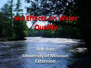
Introduction • One function of soil is to regulate the drainage, flow, and storage of water and solutes • Nitrogen, phosphorus, nutrients, elements, and compounds dissolved in the water • Soil is capable of performing this function because of its partly solid particles and partly pore-space between the soil particles.
Introduction cont. Water flows through the spaces between soil particles until the pore-spaces are filled. Some of this water will steadily drain through the soil (via gravity) and end up in the waterways and streams carrying soil particles with it. The process of carrying soil particles by water is called soil erosion.
Introduction cont. Soil Erosion: Soil erosion can cause damage to water quality when the eroded soil particles (sediments) settle out in a body of water in a process called sedimentation. Sedimentation destroys fish beds, clogs streams, reduces photosynthesis and alters stream ecology.
Introduction cont. Sediments often carry organic matter, animal or industrial wastes, toxic chemicals, and adsorbed nutrients, such as phosphorus and nitrogen. Nitrogen and especially Phosphorus stimulates the production of algae blooms that can lead to choking out beneficial plants and aquatic animals (by decreasing dissolved oxygen) in a process called “eutrophication,” which appeared to be going on at one of the research sites.
Objectives • To compare the immediate surroundings of the Huntsville Spring Branch Watershed and Indian Creek Watershed in terms of the potential for water pollution. • To characterize soils around the streams. • To evaluate the relationship between the soils and the surroundings of the streams, and the water quality of the streams.
Materials and Methods The Study Area: The Indian Creek Watershed and the Huntsville Spring Branch Watershed are sub-basins of the Wheeler Lake Basin. • Indian Creek originates from a spring northwest of Huntsville. Huntsville Spring Branch forms near downtown Huntsville.
Materials and Methods: Field Work Field Work: • Field trips were arranged to collect soil and water samples from the two watersheds. • There were two sampling sites at each location: one on the up-slope and one at the riparian zones. • Soil augers were used to collect soil samples at two different depths (0-10 cm, and 10-20 cm).
Field Work cont. Water samples were also collected by using a horizontal sampler, while the Sonde Instrument was used to measure the water quality parameters such as turbidity, dissolved oxygen, etc. The collected samples were brought to the laboratory and refrigerated at 4 °C until the time of the analyses.
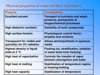
Materials and Methods: Water Quality Indicators Parameters measured: • pH • dissolved oxygen • turbidity • temperature • chlorophyll • conductivity were measured using the Sonde, which is a handheld water quality monitoring system.
Laboratory work: Soil and Water Preparation Soil samples were prepared by grinding with a mortar and pestle. Then, the samples were made to pass a 2mm-sieve. The samples were then bagged in plastic bags for analyses. The soil and water samples were refrigerated at 4 °C until the time of the analyses.
Materials and Methods: Chemical Analyses The chemical Analyses involved the following: About 0.5 g of each soil sample was weighed into microwave digester tubes and was digested in 9 mL of conc. nitric acid and 3 mL hydrofluoric acid for 15 minutes by placing the samples in microwave vessels. The vessels were sealed and heated in the microwave system. After cooling, the vessel contents were filtered into 50 ml-volumetric flasks and diluted. The samples were then analyzed for different elements by using the inductively coupled plasma-optical emission spectroscopy (ICP-OES) instrument.
Materials and Methods:Chemical Analyses To measure total phosphorus in the water samples: We measured 25 mL of each sample into a microwave digestion tube We added 0.25 g of potassium per sulfate and 1 mL of sulfuric acid into the tube. The tubes were then placed in the digestion microwave for 15 minutes. After cooling, the water in each tube was filtered into 50 mL flasks and diluted with deionized water to the 50 mL mark and stored for analysis.
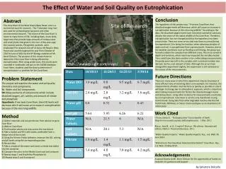
Results and discussion:Site Characteristics Upslope Riparian Zone Stream Figure. Topographic transect of sample collection and analyses relative to the stream. The topographic outlay of the research sites was remarkably different. For instance the Huntsville Spring Branch Creek was bound by a riparian zone and an up-slope. At the Indian Creek the buffer zones were less defined, thus only soils adjacent the streams were sampled and analyzed for the stream segments. These differences mean that water and pollutant transport mechanisms to the creeks are expected to be different.
Results and Data:Soil Characteristics at the sites Soil pH is a measure of the acidity or alkalinity of a soil. pH of soils at the HSBW ranged from 7.9-8.2 and 6.2-7.6 at the Indian Creek Watershed. Soils near the Indian Creek Watershed were slightly more acidic that soils near the Huntsville Spring Branch.
Results and Data Differences in pH could be due to natural causes resulting from the rock that form the soils or from human activities such as fertilizer, pesticide, or waste additions to the soil. Previous soil studies suggest that soils in the area of the two watersheds formed from similar limestone rocks. Therefore the difference in pH may be due to human activities.
Nutrient Content of Soils: (Phosphorus and Nitrogen) The P content of soils near the Huntsville Branch were greater than those of the Indian Creek P addition to soils is commonly due to human activities, such as fertilizer application and animal manures. The fact that P in the soil surface for both locations was always greater than those of the subsurface supports the suggestion that P was probably added from the surface of the soil.
Total Nitrogen Total N (NH4+, and NO3-) content of the soils was by far greater in the soil surface and subsurface soils at Johnson Road than the other sites Similar to the P content of soils, N loading of soils is due to point source and nonpoint source types of pollution.
Water Quality Indicators There was a close similarity between the pH of the samples (7.8-8.0) Turbidity, the cloudiness of water caused by individual particles (soil, plankton, organic debris) suspended in water, was highest for Old Madison Pike (4.3 NTU), Providence (2.4 NTU), than for St. Clair (0.97 NTU), and Johnson Road (0.06 NTU) The chlorophyll content of water was highest in St. Clair (1.6 µg/l), followed by Old Madison Pike (1.5 µg/l), Providence (0.78 µg/l), and Johnson Road (0.58 µg/l).
Conclusion In studying the impacts of soil properties around the Creeks in the Huntsville Spring Branch and the Indian Creek Watersheds, we sampled soils and water at different sections of the streams and analyzed for water quality indicators Results of the site evaluation and laboratory analyses indicated differences in the nature of the riparian zones in the sections of the watersheds studied. Soil samples collected from the sites showed differences in pH, Phosphorus, Nitrogen. Those differences did not translate to differences in water quality indicators.
Conclusion Though we did not measure the extent of erosion at the sites, our observation were that the Old Madison Pike and Providence sections of the Indian Creek had much more land development and constructions that may be moving down the slopes by runoff to the streams causing the water to be turbid. However, land development and construction in the Old Madison Pike and Providence sections was easily reflected in increased turbidity in the water from the streams. We hypothesized that stabilizing the riparian zones with good vegetative cover provided buffering to the water in the streams to a large extent in the Huntsville Spring Branch and to a less extent to the Indian Creek watershed, thus impacting the water quality of the watersheds.
Thank You • Meiko Thompson • Dr. Maria Nobles • Dr. Regine Mankolo • Dr. Monday Mbila • …and all of those who helped with my project.
References • Alabama Department of Environmental Management Water Quality Branch, Water Division, Indian Creek and Huntsville Spring Branch Draft Decision Report, Waterbody ID # AL/06030002-250_01 and AL/06030002-240_01, October 2003. • Brady, N.C,and R.R. Weil. 2007. Nature and Properties of Soils, The (14th Edition), Prentice Hall, • FAO – Food and Agricultural Organization. 1985. Irrigation Water Management: Training Manual No. 1 - Introduction to Irrigation, Natural Resources Management and Environment Department, FAO, Rome, Italy. • ISU -Iowa State University Extension. 2003, Resources Conservation Practices: Soil Erosion and Water Quality. http://www.extension.iastate.edu/Publications/PM1901E.pdf • Global Water Instrumentation. 2009. Water Quality Analyzer Product Description. Website: http://www.globalw.com/products/u_22xd.html