Download
1 / 19
190 likes | 354 Views
Sim Larkin, Robert Solomon (US Forest Service) Dana Sullivan, Sean Raffuse, Chris Ovard, Lyle Chinkin (Sonoma Technology) Lamb/Vaughan NASA ROSES Project Meeting UW, April 13, 2007. Current Status and Ongoing Development of BlueSky. BlueSky Framework. WEATHER FORECAST MODEL OUTPUT.

E N D
Sim Larkin, Robert Solomon (US Forest Service) Dana Sullivan, Sean Raffuse, Chris Ovard, Lyle Chinkin (Sonoma Technology) Lamb/Vaughan NASA ROSES Project Meeting UW, April 13, 2007 Current Status and Ongoing Development of BlueSky
BlueSky Framework WEATHER FORECAST MODEL OUTPUT FIRE INFORMATION REPORTING SYSTEMS FUEL LOADING MET INTERPRETER CONSUMPTION EMISSIONS TRAJECTORIES • Framework is • Modular • Open-sourced • Portable DISPERSION SMOKE TRAJECTORY & CONCENTRATION PREDICTIONS
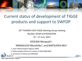
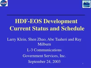
BlueSky Framework WEATHER FORECAST MODEL OUTPUT FIRE INFORMATION REPORTING SYSTEMS MM5 WRF Wildfire ICS 209 FASTRACS RAZU Manual Other FUEL LOADING MET INTERPRETER FCCS Hardy (West) NFDRS CONSUMPTION CALMM5 CONSUME 1.02 CONSUME 3 BURNUP EMISSIONS EPM FEPS BURNUP Idealized profile HYSPLIT TRAJECTORIES • Framework is • Modular • Open-sourced • Portable DISPERSION CALPUFF HYSPLIT SMOKE TRAJECTORY & CONCENTRATION PREDICTIONS
BlueSky + RAINS = BlueSkyRAINS Real-time products using BlueSky • NWS Smoke • Forecast Product • (lower 48) • FCAMMS • (5 regional centers, • covering lower 48) • AirPACT3 & ClearSky • (PNW, Lamb & Vaughan, WSU)
BlueSky-West Frank Church Evaluation: Findings and Recommendations Bluesky models long-range transport very well.
Fires are currently modeled as single plumes, lofting smoke unrealistically high and lowering ground impacts In reality, fires are made of many burning areas lofting smoke to various heights Plume Rise Modeled Reality
Fire Information Issues Fire information can be of poor quality Smoke predictions depend on the fire information U.S. Fire Report Locations Courtesy Tim Brown, DRI
Light Heavy Which model is best? Fuel Loadings (even in the same veg type) can vary hugely Photos courtesy Ottmar et al. Emissions based on Fuel Load and Fuel Consumption Model Choices
The Next-Generation BlueSky • AirFire, Sonoma Technology, Inc., • and NASA ROSES Grant • Facilitate sustained operations. • Improve inputs and settings. • Enhance user experience and access. • Add user-oriented functions. • Continue benchmarking performance. courtesy W. Hao
BlueSky Framework(new) • Revamped code-base • (Professional) • More models • More modular • More reliable • Eliminate variants
Expert Users (e.g. Incident Command Teams) SMARTFIRE: Incorporating satellite fire data Satellite fire info (NOAA HMS) Ground-based systems SMARTFIRE Reconciled fire info including sub-grid fuels and plume information BLUESKY
BlueSky OverviewAnimationsNational CoordinationWeatherRelated LinksUser GuideHelp Welcome, Sean Raffuse My AccountSign Out Legend Scenario Advanced Query Data Current Tool: Zoom In Overview Map PST Advance Hour Modeled Surface Parameter Predicted PM2.5 – 12 km Modeled Wind Parameter Surface Winds – 12 km Measured Parameter PM2.5 – AIRNow Contact UsPrivacy and SecurityStatistics Go to Default MapSet as Default MapClear Default Map
Summary: Coming Soon This spring: • Reconciled satellite data (SMARTFIRE) • Initial BlueSky Framework rewrite available • Consistent BlueSky predictions across all FCAMMS + consistent RAINS implementation Later this year: • Integrated national 36km CMAQ grid + higher-resolution regional FCAMMS forecasts • Revised interface (AIRNowTech? RAINS2?) • Partnering with AIRNow By next year (?): • Ability to ‘what-if’ prescribed burns • Ensemble forecasts
The Future? • International? (Satellite fire detects don’t stop at border) • Incorporate all fire info sources (SMARTFIRE?) • Run overall grid(e.g. 36km CMAQ, other) • Have this feed more regional applications - all in one [AQ need] (CMAQ, WRF-CHEM, other) - smoke management specific (turn fires off/on, etc...)(CALPUFF/HYSPLIT)
User Needs 2 Distinct Smoke Forecasting Needs • for Air Quality What is going to happen? would ideally like 1 number (possibly w/uncertainty or probability distribution) care about all types of pollutants (not just smoke) • for Smoke Management What if? (I do this) (or that) (or that other thing) would ideally like to know what if? to a large number of management choices Mostly just care about smoke These two distinct user groups lead to different (but related) systems
Decisions impacting smoke A Possible Solution Overall National Grid All-in-one (one atmosphere) Coarser grid • CMAQ • ~36 km grid • 1 run • all pollutants • EPA • NWS • 1-4 km grids (finer?) Regional Grids Higher resolution • Regional AQ • CMAQ • all pollutants • 1 run • EPA / NWS / ? • Smoke Management • many runs • smoke only • CALPUFF / HYSPLIT • USFS / USDOI / ?