PLATE BOUNDARIES
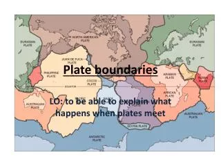
PLATE BOUNDARIES. Grade F : Name the two types of crust Grade E : Name the four different types of plate boundary. Grade D : Describe the characteristics of destructive plate boundaries. Grade C : Describe the theory that explains why plates move
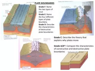

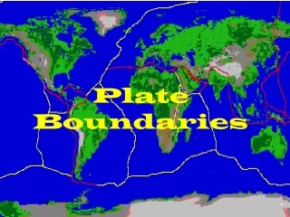
PLATE BOUNDARIES
E N D
Presentation Transcript
PLATE BOUNDARIES Grade F: Name the two types of crust Grade E: Name the four different types of plate boundary. Grade D: Describe the characteristics of destructive plate boundaries Grade C: Describe the theory that explains why plates move Grade A/A*: Compare the characteristics of constructive and destructive plate boundaries
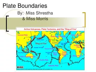
MOUNT ST HELENS, (MEDC) CASE-STUDY Causes: The Juan de Fuca Plate (Oceanic crust) moves eastwards towards the North American Plate (Continental crust) and is forced downwards. Effects: Minor earthquakes in late March 1980 caused a minor eruption of steam and ash. Minor eruptions daily, which caused a bulge to appear in northern side of mountain. Main eruption happened on May 18th 1980, 0830 hours. North side of mountain had been blown off, and reduced the mountain in height by 390 metres, creating a crater 3km long and 0.5km deep, ash fell on 11 US states, and circled the globe in 15 days. Human life – 61 deaths, mostly caused by poisonous gases released; Settlements – several logging camps destroyed Rivers and Lakes – ash fell into rivers and raised water temperature; sediment and mud choked the channels; killed all fish in lakes; Spirit Lake filled in Communication – floodwaters (caused by melting of ice at top of Mountain) washed away several road and railway bridges; ash hindered smooth running of engines Forestry – trees deforested in 250km2 area north of blast zone; trees carried down by river caused a log-jam 60km away; 10 million trees had to be replanted Services – electricity supplies and telephone wires cut Wildlife – nothing survived in blast zone Farming – 12% of crop was ruined by settling dust; crops and livestock lost due to flooding. Grade E: Name the plate boundary Grade D: Describe the effects of the eruption Grade C: Why are eruptions at destructive plate boundaries so explosive? Grade B: Explain the economic effects of the eruption Grade A/A*: Why was the eruption of Mt St Helens so successfully predicted?
MONTSERRAT ERUPTION – LEDC CASE STUDY Montserrat is a volcanic island found on a destructive plate boundary where two oceanic plates meet. (The island itself was formed as a result of this destructive plate boundary – it is an island arc). Effects: From 1995 to 1997 the volcano erupts five times; Deadly pyroclastic flows (rivers of hot ash, gas, mud and rock moving at high speeds – gas layer on top of rocks); Forests were covered in ash 23 people were killed; Two-thirds of housing destroyed and three quarters of its infrastructure (e.g. roads) destroyed. Population declined to 11,000 in 1995 from 14,333 in 1946 By Nov 1997, population fell to 3,500 74% of island’s population forced to relocate to north of island. By Nov 1997, 18% of the islanders were remaining were still in shelters Average age of the population had risen from 28.9 in 1990 to 40 in 1997, with the largest change in the proportion of people aged under 30. Grade E: What is a pyroclastic flow? Grade D: Why are pyroclastic flows only found on destructive plate boundaries? Grade C: Draw a table to list the main effects of the eruption, using headings ‘people’, ‘environment’ and ‘economy’ Grade B: Why were the living conditions on the island so poor? Grade A/A*: What evidence is there that, given time, the island will recover from the disaster?
KOBE DISASTER – MEDC EARTHQUAKE Japan is located on the Pacific Ring of Fire. The Eurasian Plate (continental crust) is being approached by the Philippines Plate (Oceanic crust) and Pacific Plate (oceanic crust). As the Pacific and Philippines Plates are heavier, they are being forced under the Eurasian Plate. Over the centuries, volcanic activity at this plate boundary has created the Japanese island arc. Kobe, the epicentre of the earthquake is on a minor fault, the Nojima Fault. Effects: The earthquake happened at 5.46am on the morning of January 17th. It measured 7.2 on the Richter scale, and lasted for 20 seconds. 200,000 buildings collapsed, 1km stretch of Hanshin Expressway collapsed, long sections of bullet train route collapsed, several trains on minor lines derailed. Essential services disrupted (gas, electricity and water); Fires caused by broken gas mains broke out over the city – made worse by many houses made out of wood; Roads grid locked, emergency services delayed; 230,000 people made homeless and had to live in temporary shelters; Shortage of blankets, clean water and food; many aftershocks lasted for several days Many industries, such as Mitsubushi and Panasonic, were forced to close. Final death toll at 5,500, injured at 40,000, and 180,000 houses destroyed Grade F: What type of plate boundary is Japan located on? Grade E: Describe the primary effects of the earthquake Grade D: Describe the secondary effects of the earthquake. Grade C/ B: Why are the effects of earthquakes in MEDCs often mainly economic? Grade A/A*: How did the government and people respond to the disaster?
Laser surveying and ………………… will identify ………………… across a ………………… Seismometers will ………………… shock waves from the e……………… of an earthquake. The level of ……………… in wells rises and falls as the ground is ……………… before an …………………… …………………… and compression of the ………… can be recorded automatically and this data is also sent to …………… R…………… gas is released from within minerals as …………… increases during the build up to an ……………………………………. Also, g………………, magnetic properties of rocks and …………………… to ………………… current all change as ………………… increase during the build up to an earthquake. Grade E: Name one technique for predicting earthquakes Grade D: Why does the level of water rise before an earthquake? Grade C: How do computers help in predicting earthquakes? Grade B: Why can MEDCs successfully predict earthquakes? Grade A/A*: Why can LEDCs not predict earthquakes?
RESPONSES TO EARTHQUAKES MEDC responses / precautions: Emergency drills – preparation, e.g. Kobe, September 1st. Evacuation procedures – routes planned Building regulations – improved to a higher standard to withstand a magnitude of earthquake; Building materials – since the majority of Kobe’s houses were built from wood, most houses now are being designed to withstand fire; Further regulations control the design of buildings – Kobe’s authorities have encouraged buildings to be spread out to stop fire spreading. Also, Fire Authorities have been practising dealing with fires from earthquakes; Population of Japan have been trained in first aid. Shelter and food supplies planned. Essential services have been properly designed – water pipes not to fracture and gas mains. Relief grants, low cost loans and tax breaks for victims of earthquake have helped the city back on the road to recovery Emergency funds set up to rebuild infrastructure. LEDC responses/precautions: Authorities around the world encouraged Red Cross and other charities to come into the country to help provide food and shelter. Emergency shelters set up. Financial relief from World Bank. Charities help keep water clean and free from disease or provide essential services. Often there is complete disaster in the area, so authorities are slow to rebuild – Bam, in Afghanistan/Iran had still not responded eight to ten months after the earthquake. This is due to lack of money, planning and prediction. Prediction is rare, because authorities have no money to invest. Planning is often non-existent, so the effects are often worse. Building structure and design means that they will often collapse completely and due to high population in the cities means that the death toll is often worse. Grade D/E: Describe the responses of MEDCs. Grade C: Compare the responses made by MEDCs and LEDCs. Grade B: Why is the recovery time of LEDCS often longer than MEDCs? Grade A/A*: Why are the effects of tectonic hazards often worse in LEDCs?