Download
1 / 32
350 likes | 410 Views
Learn about the 3 types of plate boundaries: Divergent, Convergent, and Transform. Dive into examples of each type with detailed explanations and diagrams. Explore mid-ocean ridges, mountain ranges, deep sea trenches, volcanic arcs, and more. Enhance your understanding of Earth's dynamic processes.

E N D
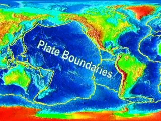
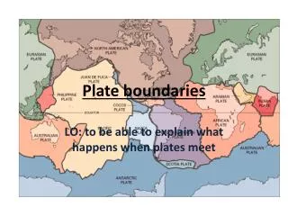
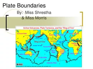
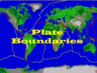
3 TYPES OF PLATE BOUNDARIES • Divergent • Convergent • Transform
Divergent plate boundaries Almost all the Earth’s new crust forms at divergent boundaries, but most are not well known because they lie deep beneath the oceans. These are zones where two plates move away from each other, allowing magma from the mantle to rise up and solidify as new crust.
One divergent plate boundary is actively forming the Red Sea. Although the Arabian peninsula and Africa were once linked to form a single continent, they are now being ripped apart. The white arrows show the directions the two plates are moving. Here, you can see that a new ocean, the Red Sea, is being formed as they separate.
Divergent boundaries build chains of volcanoes and rift valleys called a mid-ocean ridge. Mid-ocean ridges are found in the oceans-they are like mountain ranges on the ocean floor created by the new lava that is bubbling up! Little by little, as each batch of molten rock erupts at the mid-ocean ridge, the newly created oceanic plate moves away from the ridge where it was created.
MID-OCEAN RIDGES Atlantic ocean is widening as the Pacific is getting smaller
Mid-Atlantic Ridge a mostly underwater mountain range of the Atlantic Ocean and Arctic Ocean that runs from 87° N (about 333 km south of the NorthPole) to sub antarctic Bouvet Island at 54° S. The highest peaks of this mountain range extend above the water mark, to form islands.
3 TYPES OF CONVERGENT BOUNDARIES 1. OCEAN-CONTINENTAL 2. CONTINENTAL-CONTINENTAL 3. OCEAN-OCEAN
A. Ocean-Continental Collision In a contest between a dense oceanic plate and a less dense, buoyant continental plate, guess which one will sink?
Ocean plate! The dense, leading edge of the oceanic plate actually pulls the rest of the plate into the flowing asthenosphere and a subduction zone is born! At a subduction zone, where the two plates intersect, a deep trench forms. These trenches are called deep oceanic or deep sea trenches.
The next image shows a slice through the Earth at a convergent plate boundary. This view illustrates just one of the ways that plates behave when they collide. In this case, subduction is occurring-one plate is pulled beneath another, forming a deep ocean trench.
The long, narrow zone where the two plates meet is called a subduction zone.
Characteristics of a subduction zone (ocean-continental collision) A subduction zone can be located by looking for curved volcanic mountain ranges on the land with deep trenches in the water. (no islands created)
The Cascadia subduction zone is a very long sloping fault that stretches from northern Vancouver Island to northern California. An example of volcanic mountains formed by ocean-continental convergence is the Cascade mountain range, including Mt Hood and Mt St Helens
An example of this kind of convergence produces the spectacular volcanic landscape of the Northwest-the coast of Oregon, Washington, Alaska and Canada. This type of convergent plate boundary, called a subduction zone, is known for producing very strong, historic earthquakes • A subduction zone can be located by looking for curved volcanic mountain ranges on the land with deep trenches in the water. (no islands created)
2.Continental-Continental The two plates override each other, thickening the lithosphere and producing mountains. The Himalayas are a good example of this. Mountain chains are formed in this way, these are not volcanic mountains. Note the lack of volcanoes.
Mountain Ranges Mt. Everest, Nepal
Appalachian Mountains Formed by collision of two plates. The Ouachita Mountains in Arkansas and Oklahoma were originally part of the Appalachians as well, but were disconnected through geologic history.
Arbuckle Mountains Located in Davis, Ok. Folded mountains formed by plate collisions.
3. Ocean-Ocean Note the trench and volcanic arc. Japan is an example of such an island arc.
Puerto-Rico Trench Perspective view of the sea floor of the Atlantic Ocean and the Caribbean Sea. The Lesser Antilles are on the lower left side of the view and Florida is on the upper right. The purple sea floor at the center of the view is the Puerto Rico trench, the deepest part of the Atlantic Ocean and the Caribbean Sea.
Major Ocean Trenches Trench Ocean Depth (meters) Marianas TrenchPacific Ocean 10,911 Tonga TrenchPacific Ocean 10,882 Kuril TrenchPacific Ocean 10,542 Philippine TrenchPacific Ocean 10,540 Kermadec TrenchPacific Ocean 10,047 Japan TrenchPacific Ocean 9,000 Puerto Rico TrenchAtlantic Ocean 8,605 Peru-Chile Trench or Atacama TrenchPacific Ocean 8,065
Transform Boundaries The San Andreas Fault is a geological fault that runs a length of roughly 800 miles (1,300 km) through western California in the United States. The fault marks a transform boundary between the Pacific Plate and the North American Plate.
Movement of the Fault All land west of the fault on the Pacific Plate is moving slowly to the northwest while all land east of the fault is moving to the southwest under the influence of plate tectonics. The rate of slippage averages approximately 33-37mm/yr. Projected motion indicates that the Gulf of California will expand northward at the same time that the landmass west of the fault, including the Baja California peninsula and the California coast (including Los Angeles) slides past San Francisco, then continuing northwestward as an island mass toward the Aleutian Trench, over a period of perhaps twenty million years.
References Geology Rocks: PlateTectonics, 2007 Jon Hill & Katie Davis http://www.geologyrocks.co.uk/tutorials/plate_tectonics_introduction Wikipedia The Dynamic Earth, USGS http://pubs.usgs.gov/gip/dynamic/dynamic.html