The Pacific Coast Fog Project: A Multi-disciplinary Web-based Climate Resource
Discover how experts collaborate to provide weather and fog data for ecologists managing resources along California's coast.

The Pacific Coast Fog Project: A Multi-disciplinary Web-based Climate Resource
E N D
Presentation Transcript
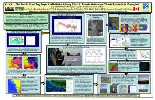
The Pacific Coast Fog Project: A Multi-disciplinary Effort to Provide Web-based Climate Products for Ecologists Gary P. Ellrod,1 Alicia Torregrosa,2 Cynthia Combs 3 and Ismail Gultepe 4 1 Ellrod Weather Consulting, Granby, CT 2 U.S. Geological Survey, Menlo Park, CA 3 CIRA, CSU Ft. Collins, CO 4 Environment Canada, Toronto, Ontario * Lead Authors’ Email Addresses: Gary.Ellrod@gmail.com , Alicia.Torregrosa@usgs.gov, Cindy.Combs@colostate.edu, andismail.gultepe@ec.gc.ca P 1.43 Project Overview The Pacific Coast Fog Project pools the expertise from multiple science disciplines to provide regional and local climate and weather information on the frequency and character of fog for biologists and botanists to effectively manage natural resources along the coast of California. The panels in this poster show samples of contributions from collaborators. 11. Possible User Product Formats Observed low clouds from MODIS (light gray) overlain on Landsat image (left) (C. Potter & C. Hiatt, NASA), low cloud diurnal frequency from GOES (lower left) (Combs, CIRA), MODIS-based annual indices (P. Williams, Los Alamos) or fog frequency for any given day of the year (lower right) ( Gultepeet al 2007, BAMS) 2. Long Term Climatic Trends Collaborating scientists (not in boxes 1 -12): A. Flint, L. Flint, M. Madej, and C. Ng (USGS), A. Jousse (UCLA), S. Iacobellis and R. Schwartz (UCSD) J.Dungan (NASA), C. Stills, D. Fischer and S. Baguskas (UCSB), L. Gallardo, R. Garreaud and R. Rondanelli (U. Chile), K. Redmond (DRI – Reno).; and natural resource manager product advisors:: L. Michelli (Pepperwood Preserve), Natalie Gates, Ben Becker and Daphne Hatch (U.S. National Park Service), A. Gunther (BACCC). 12. Remote Sensing Upgrades 3. Inter-annual Effects (Pacific Decadal Oscillation) Correlation between maximum temperature contrast (inland to coast) and airport records of fog frequency can be extrapolated back to 1900 to infer that fog has diminished ~33%, although there has been an uptick in recent years possibly related to “cool phase” of Pacific Decadal Oscillation (PDO). Global warming should lead to an increase in coastal fog. (J. Johnstone, UW-Seattle) New satellite assets such as night visible from VIIRS on NPP (above) and GOES-R will enhance future observing capabilities (Thomas Lee, NRL-Monterey) 10. Regional Climate Modeling The foggiest summers along the CA coast are correlated with cooler SSTs and stronger northerly surface winds associated with the “cool phase” of the PDO (J. Johnstone, UW-Seattle) RegCM-UW (ICTP) regional climate model produces realistic fog frequency (left, compared with ship observations, right) by improving resolution, terrain, and PBL representation. (T. O’Brien (LBNL), J. Johnstone (UW-Seattle)) 9. Microphysics 1. Fog Impacts on Pacific Coast Ecology Studies at Environment Canada show that accurate forecasts of fog visibility require data on both fog droplet concentration (Nx) and Liquid Water Content (LWC) (I. Gultepe, Env. Canada) 4. Short Term (11-year) GOES Climatology 8. Nowcasting / Short Range Prediction NWS forecasters use satellite products such as GOES low cloud base (left), Windsat scatterometer winds (right), and MODIS SST, as well as surface pressure and wind from land stations and buoys. (M. Nordquist, NWS) Low cloud frequency (%) at 1200 and 0000 UTC, July 15 - Aug 15, 1999-2009 for Marine Layer Depth of 751-1250m at 1200 UTC. (C. Combs, CIRA/CSU) GOES LCB at 1330z, 9 Mar 20112 Windsat 10m winds on 1 Nov 2011 Redwood trees (Sequoia sempervirens) have retreated to small enclaves along the California coast (left). Summer fog helps to compensate for lack of precipitation along the Pacific Coast (middle) in supplying moisture for redwoods and other plant species. Hydrogen isotope analysis (right) shows that a significant percentage of moisture uptake from plant species in summer originates from fog. (E. Burns, Save the Redwoods League). Fog also reduces heat spikes that kill young salmon, affect summer energy costs and reduces heat burn on important local crops such as grapes. 6. Boundary Layer Meteorology 7. Real-time Surface Data Collection A pilot project during summer 2012 collected data from instruments donated by Env. Canada to supplement those at Bodega Bay, CA and Pepperwood Preserve for fog research and validation. (Torregrosa, USGS, I. Gultepe (Env. Canada), I. Faloona (UC-Davis), J. Underwood, (Ga. Southern U.), D. Andersen (Pepperwood)) • 5. Short Term MODIS Climatology Graphic from COMET module shows that low cloud maxima occur upwind of capes as Marine Boundary Layer (MBL) is forced to rise. Cloud minima form downwind of capes in “expansion fans” where MBL sinks. These patterns are seen in climatology panels 4 and 5 at left. Low level jet is enhanced by proximity to coastal hills leading to strong upwelling. (I. Faloona, UC-Davis) Maxima in MODIS 1:30 PM cloud frequency (such as near San Francisco and Monterey) do not correspond to locations of redwood forests (black contours), suggesting the need for afternoon solar radiation, sheltered locations or optimum soil conditions. (E. Waller, UC-Berkeley) 915MHz wind profiler and Radio Acoustic Sounder System (RASS) Fog Cam at Pepperwood Preserve We thank the California Landscape Conservation Cooperative and Gordon and Betty Moore Foundation for supporting the April 2012 kickoff workshop at USGS in Menlo Park, CA and ongoing collaboration. Fog instrument sites Visibility traces for fog events Harp fog collectors Vaisala FD12P Weather Station ASOS/AWOS/RAWS stations