Download
1 / 23
240 likes | 544 Views
DEVELOPMENT OF A HIGH RESOLUTION METEOROLOGICAL NOWCASTING SYSTEM FOR THE U.S. ARMY OBJECTIVE FORCE. Mr. Robert E. Dumais, Jr. U.S. Army Research Laboratory CISD BE Boundary Layer Meteorology Branch 2003 BACIMO: 09 Sep 2003 U.S. Naval Research Laboratory Monterey, CA.

E N D
DEVELOPMENT OF A HIGH RESOLUTION METEOROLOGICAL NOWCASTING SYSTEM FOR THE U.S. ARMY OBJECTIVE FORCE Mr. Robert E. Dumais, Jr. U.S. Army Research Laboratory CISD BE Boundary Layer Meteorology Branch 2003 BACIMO: 09 Sep 2003 U.S. Naval Research Laboratory Monterey, CA.
DEFINITION OF NOWCAST • Often appears to take on different meanings based on individual perceptions • A basic description by Browning (1982): “The term nowcasting symbolizes an observation-intensive approach to local forecasting, with timely use of current data, in which remote sensing plays a dominant role” • Emphasis more towards the “now” part of the time spectrum
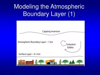
WHY IS IT IMPORTANT ? MM5 Forecast Model – 4D Data Cube 20 km 80 km 30 km current and extended range trajectories chem/bio mission execution acoustic and electro optical propagation and inherent signatures urban war environment scenegeneration Is there an Army “Nowcast” requirement? - Concepts for SWO / IMETS-light in Combat Brigades - IMETS ORD - Relevance to Objective Force/FCS INTEL - New decision aids and weather products for echelons below brigade - Dismounted Battlespace Battle Lab
WHY IS IT IMPORTANT ? profilers Nowcast can be run near battlefield edge to improve UAV operations uav, ugv, ucv SHADOW TUAV lessen bandwidth concerns associated with reachback for timely localized guidance Dropsondes & balloons Many new sources of non-conventional battlefield meteorological and surface data to be available (satellite EDRs, dropsonde, profilers, doppler, surface sensors, deployable met towers, etc.) Surface robotic sensors Surface met measurements satellite
FCS - A “sensor rich” environment C2, Brigade ISR collection & analysis, UAV/UGV and sensor webs • Develop capability for IMETS-light and 2-person • SWO Combat Weather Teams in MI CO • Support C2 “on-the-move” with up to date met data, • met-sat overlays and weather impact decision aids • fully compatible with CTP and C4I systems • Continue to exploit reach-back for “top-down” • weather (from DIV and above IMETS and AF • Weather Hubs) for 24 hr and 5 day forecasts • Fuse higher echelon forecasts with • local sensor obs • remote sensing (METSAT) • weather HUMINT • Improve first-in and daily mission support • 0-3 hr local nowcasts • 0-48 hr regional forecasts (MM5) • 3-5 day theater forecasts (NOGAPS) • Support Brigade ops, UAV, RSTA & weather • over complex terrain and MOUT
New capabilities are needed to exploit the potential web of sensors on the future battlefield Data Fusion of information from Combat Weather Teams, G2, and other soldier observations including weather HUMINT: “A heavy rain has begun now where we are” APT ~ 4 km/pix, Dynamic Dust Storm HRPT ~ 1.1 km/pix Dynamic Soil Moisture Dynamic Snow Cover Polar and geostationary WxSAT (GOES, DMSP, NPOESS, …) UAV derived data (ground vs air speed, snow cover, visibility…) and perhaps direct sensor data Robotic Ground Vehicles may collect and use local met data - also should exploit NBC RECON met data, armor wind/pressure data, etc. Surface sensors: IREMBASS-compatible TACMET II sensor and ceilometer; Remote Miniature Weather Sensor (RMWS - Infantry and AF Combat Weather), Miniature Remote Weather Station (MRWS - SOF), Meteorological Automated Sensor and Transceiver (MAST); & AF TACMET-MOD II, Air Traffic Control Towers, Airfield Automatic Met Equipment, AF Marwinsonde profiles when in theater Arty-met surface and profile observations from AN/TMQ-50 Semi-Automated Meteorological Station (SMS) and AN/TMQ-41 Meteorological Measuring Set
Exploitation of Next generation METSAT • Imagery • Sea Surface Winds (Speed and Direction) • Sea Surface Temperature (SST) • Atmospheric Vertical Temperature Profile • Atmospheric Vertical Moisture Profile • Cloud Base Height • Cloud Cover/Layers • Pressure (surface/profile) • Soil Moisture (Surface) • Precipitation Type/Rate • Suspended Matter • Cloud Optical Thickness • Snow Cover/Depth • Land Surface Temperature • 15. Precipitable Water • Cloud Top Temperature • Cloud Top Pressure • Aerosol Optical Thickness • Cloud Ice Water Path • Vegetative Index • Aerosol Partticle Size • Cloud Liquid Water • Albedo (Surface) • Cloud Effective Particle Size • Total Water Content • Ocean Wave Characteristics • Active Fires • Surface Type Proposed NPOESS Low Rate Data (LRD) - 3.5 to 4 Mbps satellite broadcasts will support future products. Current draft of priorities include these Environmental Data Records: NPOESS consolidates DoD DMSP and NOAA POE Satellite programs • Evaluation of Aerospace Corp Direct Receive Antenna - • Prototyping a low resolution solution - NPOESS L-Band Low Rate Data Channel surrogate is DMSP RDS (S-band). Aerospace is developing an antenna/receiver potentially suitable for Army “direct receive” capability deployed at small units • Potential as antenna for Mobile Weather Imagery Receipt • Supports current weather during comm-sat loss & ARTY-MET • “Low cost” horn antenna packaging analog electronics and receiver on the structure with “on-board baseband encrypted interface” • Requires tracking mount, PC with mission software and crypto device Using DMSP F-15 Real-time Data Smooth (RDS) 2.5 km Line Scan and 15-50 km SSM/I and 45-175 km SSM/T as a NPOESS surrogate for EDR data
34 Vehicle Mounted IMETS 92 Light Systems Contrasts in Weather Technology for DIV and Above Vs BDE and Below
Key Components of the Prototype Army Nowcasting System A NWP model with 4DDA (or possibly 3DVAR) that can be rerun on an 1-3 hourly cycle at mesogamma scale resolution (2.5 km) and for a Brigade-size 150 km x 150 km domain, to produce updated high quality local meteorological background fields (can ingest high temporal and spatial resolution local data sources) A fast objective analysis module that can produce 15-20 minute “updated” 3D analyses for sub-Brigade size (20 km x 20 km) local domains nested within the 150 km x 150 km NWP domain, using a blend of the most recent NWP output & the previous objective analysis output for the 1st guess background fields (along with fusing the most recent local observations), and remaining static until the next update analysis For operational lower echelon application,ACCURACYmust be balanced againstTIMELINESS
Key Components of the Prototype Army Nowcasting System • NWP model : NCAR/PSU MM5 V3 for Brigade-size region • - single nest, with background fields for initial and lateral boundary conditions from AFWA operational 15 km MM5 output • - 2.5 km, 61x61x31 • - 3 h forward integration • ASSIMILATION OF LOCAL DATA INTO MM5 • * Use remote sensing to update terrestrial fields in MM5 REGRID module, such as skin/sea surface temperature and binary snow cover • * IF MM5 4DDA/Observational Nudging: will require a dynamic assimilation period, and observations arranged in MM5 MMOBS_DOMAINx binary file format • * IF MM5 3DVAR: will require appropriate constraint selection for mesogamma scale, and data arranged in MM5 “Little R” input format - Seeking best compromise between complexity, timeliness and accuracy
Key Components of the Prototype Army Nowcasting System Local (20 km x 20 km) objective analysis for 1st generation IMETS nowcast • - A 3D objective analysis based on either a successive corrections or a Bratseth scheme, nested within the 150km x 150km NWP domain • The analysis updates use the background fields from the 3 h NWP forecast, in addition to local observations (predominately surface sensor, dropsonde, or UAV/UGV) since the last analysis • Observations may be “averaged” or “superobed” since last analysis time • Analyses are updated every 20 minutes • Analysis likely to be at the same mesogamma resolution as the NWP model (2.5 km) • Analysis remains static until next analysis cycle • - High quality, high resolution background field data from the nowcast mesogamma NWP model is critical to the accuracy of the local analysis!
TACTICAL ARMY NOWCAST STRATEGY DTED terrain BRIGADE DOMAIN metsat EDRs 150 x 150 km MM5 mesogamma NWP forecast (with 4DDA) every hour Profilers and lidars AFWA 15 km MM5 fields local surface observations Terrestrial via remote sensing Radiosondes,dropsondes, & pibals PLATOON DOMAIN Multiple platoon domains are possible with Brigade domain 20 x 20 km mesogammaobjective analysis (every 15 min) Previous objective analysis UAVs Inputs going to objective analysis module NOWCAST CYCLING Inputs going to NWP forecast module
Local MM5 runs (Brigade size domain) An example of a 2.5 km resolution MM5 run over Utah using AFWA 15 km MM5 as initial and lateral boundary conditions (3 h fcst) Primary purpose: Provide 1st guess background for platoon size, 15 minute update cycle, objective analyses 1st guess and lateral boundary conditions from AFWA operational MM5 Brigade & below local battlefield observations: surface, raobs, dropsondes, UAVs & UGVs, satellite, deployable towers Rerun hourly ( 3 h forward integration) with observational nudging 4DDA or 3DVAR- single nest configuration Ingest updated skin/sea surface temperature, snow cover, & perhaps other surface fields from recent satellite passes
Successive Corrections Objective Analysis Development - Surface objective analysis is now combined with upper air objective analysis ( using similarity theory) WSMR SAMS network observations Will design with platoon-size applications in mind; 10-15 min updates Possible PDA application Mesogamma resolution MM5 1st guess field Mesogamma wind field after objective analysis
Other Prototype NOWCAST Components • A diagnostic microscale boundary layer and/or surface model coupled to the objective analysis fields to provide higher resolution near-surface detail • Postprocessing algorithms for the objective analysis output • JAVASPACES-based system to ingest & stage regional and local observational and model-derived input meteorological data sources for NOWCAST (including its own output)
Couple Objective Analysis Fields to a Surface Layer Microscale Diagnostic Wind Model higher resolution terrain effects on surface winds can be incorporated diagnostically 57.5 km (2.5 km grid) 1.4 km (0.1 km grid) Ft. Benning, GA in August 2000. Wind arrows and streamlines on both graphs, contour lines for small area (right). The smaller area will fit inside the small square on the left image (3 x 3 km). The microscale output shows large changes in wind speed and direction within the area represented by one wind arrow on the mesoscale output.
FUTURE: EXTEND SURFACE DIAGNOSTIC WIND MODEL TO 3D Mass consistent; solve the functional: Cartesian coordinate and multigrid numerical solution technique (major computational speed up) Flow partitioning using bulk Richardson number Includes effects of topography, and small surface features such as forests and buildings 3DSTAT is not an LES or CFD !!
POSTPROCESSING 3D OUTPUT FROM MODELS Cross-Sections
METSPACES Concept for Battlefield NOWCAST Data Management - customized implementation of Sun Microsystems’ JavaSpaces networking technology - coordinating, collecting and disseminating of the various types of data products generated by NOWCAST - In a networked shared-memory environment, the various types of Nowcasting components can be loosely-coupled with one another through simplified data exchange mechanisms - primary intent of this environment is to shield sophisticated legacy systems by establishing an abstract interface through which they can automatically interact with prescribed data
Preliminary Nowcast Proof of Concept Study Data Set - Three months of Oklahoma Mesonet Observations: 22 Jan- 28 Feb 2000 (38 days); 1 May - 29 Jun 2000 (60 days) Applies simple data fusion of actual surface sensor observations with the standard 0-24 hourly outputs from BFM, the current tactical Battlescale Forecast Model used in the field on the AN/TMQ-40C Integrated Meteorological System (IMETS) Reports the absolute forecast error averaged over the other 96 Oklahoma surface stations at each hour of the day (0-24) and then averaged over the 38 and 60 day study windows Clearly demonstrates the progressive improvements to BFM by fusing 1, 3, 5 and 12 on-scene, real-time surface observations from a few surface observations scattered across the Oklahoma Mesonet to produce a prototype 0-hr nowcast for each hour of the day: % Reduction in Absolute Error Using: 1 Observation 3 Observations12 Observations Temperature: 25 - 30 % 40 - 45 % 60 - 65 % Wind Speed: 15 - 25 % 25 - 35 % 30 - 45 % Wind Direction: 10 - 20 % 20 - 30 % 35 - 45 % Relative Humidity: 0 - 25 % 20 - 35 % 40 - 60 % Additional improvements are expected when the observations can be assimilated directly into a mesoscale numerical model (as opposed to just the data fusion post-processing used here)
Future: Improved Response Filter for Objective Analysis • Improve handling of irregularly distributed observations • Linear least squares problem • Find weights that produce desired response function • Take derivative with respect to weights • Invert matrix for weights * Slide borrowed from Dr. Mark Askelson, University of North Dakota
Response Filter • Example • Coherent input field looks incoherent after analysis (upper right) owing to impact of irregular data distribution the response function. • Want to improve technique so that result is coherent (lower right) * Slide borrowed from Dr. Mark Askelson, University of North Dakota
POSSIBLE FUTURE EFFORT WITH CG/AR: Ensemble Data Assimilation • ■ Develop and Assess Capability of the Maximum Likelihood Ensemble Filter (Zupanski, 2003) Data Assimilation approach on the meso-micro scales • suited for highly nonlinear operators • - no adjoints • - no assumptions about observation correlations • - perturb analysis rather than individual obs • - optimize non-quadratic cost function, using a • superior Hessian preconditioner • - allows for both an estimate of uncertainty and for • the most likely deterministic solution