Download

1 / 16
0 likes | 1 Views
presentation about air mass

E N D
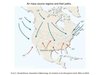
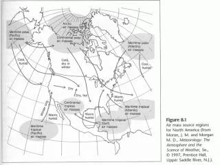
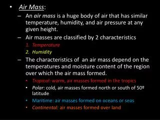
Source Regions The regions where air masses attain the uniform condition of temperature and humidity are called Source Regions. The source regions are the essential determining factor of the initial properties of the airmass. Following are the different source regions: a. Large snow or ice covered Polar Regions b. Tropical oceans c. Large desert areas
Source Region TropicalMaritime (TM) Originates over the tropical oceans Warm and Moist Tropical Continental (TC) Originates over the tropical continents Warm and Dry Polar Maritime (PM) Originates over mid to high latitude oceans. Cold and moist Polar Continental (PC) Originates over high latitude continents (about 60 degrees north) Cold and dry
Classification of Air mass Air masses are classified basing on moisture and tempera-ture. Temperature and moisture content depends on the source region whether it is sea (maritime) or land (continental). Moisture: a. Maritime air mass (m): Moist Continental air mass (C): Dry Temperature: a. A for arctic (60o-90o N) : Very cold b. P for polar (40o-60o N or S) : Cold c. T for tropical (15o-35o N or S) : Warm d. E for equatorial (15o N-15o S) : Very warm e. AA for Antarctic (60o-90o S) : Very cold
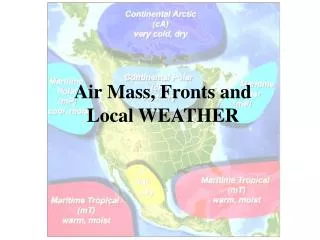
Global Airmass a. Continental Arctic (cA) : Very cold, very dry b. Continental Antarctic (cAA) : Very cold, very dry c. Continental Polar (cP) : Cold and dry d. Continental Tropical (cT): Warm and dry e. Maritime Tropical (mT): Warm and moist f. Maritime Equatorial (mE): Very warm, very moist g. Maritime Polar (mP): Cool and moist
Modification of Air mass An air mass tends to change its initial properties when it leaves its source region to move over new region/area. The degree of modification of an air mass depends on: a. The speed with which it travels. b. The nature of the region it moves over. c. The temperature difference between the new surface and the air mass.
Cold Airmass A cold airmassis an airmass whose temperature is lower than the underlying surface. For example, an airmass of 150C temperature lying over a surface of 200C. The origin of cold airmass is generally polar area which may be either continental or maritime origin.
Properties of cold Airmass • A cold airmass is generally originated from the Polar and Arctic area. Cold airmass is dry or moist depending on whether the source region is land or sea. • When this cold airmass moves to lower latitudes of warmer surface then its properties are modified. The warmer surface adds energy to the airmass, heating from below, as such, its instability and convective activities increase and cumuliform type of clouds form. • Rain/thundershower, turbulence, icing, hails etc, are the common weather in cold airmass.
Warm Airmass An airmass having higher temperature than the underlying surface is called warm airmass. An airmass with 200C temperature lying over a surface of 150C is an example of warm airmass. While moving to higher latitudes of colder surface, it becomes a stable airmass resulting low clouds, fog, mist etc.
Properties of Warm Airmass • A warm airmass is originated from the tropical and equatorial regions. The airmass will be warm and dry whereas the maritime airmass will be warm and moist. • While moving to higher latitudes of colder surface it become stable and layer type of clouds form with continuous drizzle type of precipitation. Fog and mist also form in the warm and stable airmass.
Airmass over Bangladesh and India a. Tropical Maritime Air: Tropical maritime air originates in the sub-tropical high of North Pacific Ocean and arrives over India and Bangladesh through Southeast Asian countries during the Summer Monsoon. It has high temperature, high relative humidity and high dew point. Rain, Shower, turbulence etc are common in this airmass. b. Tropical Continental Air: Tropical continental air is most common over India and Bangladesh. Particularly in the winter season it over runs the country. It originates in the great ‘Siberian High’ and moves over India sub-continent as cold dry airmassin Winter Season/NE Monsoon.
Airmass over Bangladesh and India c. Polar Continental Air: Polar Continental Air is cold and dry, and makes infrequent intrusions into northern India and Bangladesh in winter season. This airmass is responsible for severe cold waves which occasionally affect Northern India and Bangladesh. d. Equatorial Maritime Air: The origin of Equatorial Maritime Air is South Indian Ocean. It crosses the Equator and moves to Indian sub-continent in the Summer Monsoon period. As it crosses the Equator into the Northern Hemisphere, it undergoes surface heating and cumuliform types of cloud increases giving rain/thundershower.
Identification of Airmass An airmass is identified: a. From the temperature and dew points as plotted on surface charts. b. From the amount of the temperature and dew point spread on Tephigram (T- gram). c. By locating the approximate source regions as indicated by streamlines on upper wind charts. d. From the type of clouding and weather that occur in the interior of the airmass. e. From the existing visibility condition.
WX Associated with Airmass Unstable Stable Stratiform cloud pptn Smooth air Fair to poor visibility • Cu, Cb Cloud • Showery pptn. • Turbulence • Good vis except in shower or blowing snow or sand storm.