Download
1 / 23
310 likes | 1.4k Views
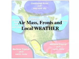
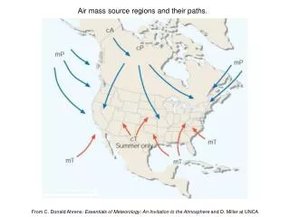
Air mass source regions and their paths. . From C. Donald Ahrens: Essentials of Meteorology: An Invitation to the Atmosphere and D. Miller at UNCA. Cold Front. Cold Front Cross-Section. Possible Conditions Near a Cold Front. Warm Front. Warm Frontal Cross-Section.

E N D
Air mass source regions and their paths. From C. Donald Ahrens: Essentials of Meteorology: An Invitation to the Atmosphere and D. Miller at UNCA
Occluded Fronts • As a surface cyclone evolves, its associated cold front will move faster than its warm front and the two will eventually collide to form an occluded front • Two Types of Occlusion • Warm • Cold
Warm Occlusion Warm is a relative term meaning cool air moves over colder air
Cold Occlusion Very cold air overtakes the cold air already in place
Cyclogenesis Cyclogenesis: Development or strengthening of a mid-latitude cyclone Cyclones form where there is a contrast between air masses (warm vs. cold)
Polar Front Theory (b) (c) (a) (d) (e) (f)
Step One cP and mT air meet at a stationary front. There is a trough of low pressure with higher pressure on both sides, cold air to the north, and warm air to the south. Wind flows parallel to the front. From C. Donald Ahrens: Essentials of Meteorology: An Invitation to the Atmosphere and D. Miller at UNCA
Step Two Under the right conditions, a wavelike kink forms on the front. The wave that forms is known as a frontal wave. The circulation of winds around the cyclone tends to produce a wavelike deformation on the front. From C. Donald Ahrens: Essentials of Meteorology: An Invitation to the Atmosphere and D. Miller at UNCA
Step Three Steered by the winds aloft, the system typically moves east or northeastward and gradually becomes a fully developed open wave in 12 to 24 hours. Open wave – the stage of development of a wave cyclone where a cold front and a warm front exist, but no occluded front. The center of lowest pressure in the wave is located at the junction of the two fronts. From C. Donald Ahrens: Essentials of Meteorology: An Invitation to the Atmosphere and D. Miller at UNCA
Step Four The central pressure is now lower and several isobars encircle the wave. The more tightly packed isobars create a stronger cyclonic flow and winds swirl counterclockwise and inward toward the low’s center. Energy for the storm is derived from rising warm air and sinking cold air transforming potential energy to kinetic energy (energy of motion). Condensation supplies energy through latent heat release. Converging surface winds produce an increase of kinetic energy. The cold front advances on the warm front. From C. Donald Ahrens: Essentials of Meteorology: An Invitation to the Atmosphere and D. Miller at UNCA
As the open wave moves eastward, central pressures continue to decrease, and the winds blow more vigorously. The faster-moving cold front constantly inches closer to the warm front, squeezing the warm sector into a smaller area. Eventually the cold front overtakes the warm front and the system becomes occluded. The storm is usually most intense at this time, with clouds and precipitation covering a large area. Step Five From C. Donald Ahrens: Essentials of Meteorology: An Invitation to the Atmosphere and D. Miller at UNCA
Step Six The intense storm gradually dissipates because cold air now lies on both sides of the cyclone. Without the supply of energy provided by the rising warm, moist air, the old storm system dies out and gradually disappears. Occasionally, a new wave will form on the westward end of the trailing cold front. • The entire life cycle of a wave cyclone can last from a few days to over a week. From C. Donald Ahrens: Essentials of Meteorology: An Invitation to the Atmosphere and D. Miller at UNCA
A series of wave cyclones (a "family" of cyclones) forming along the polar front From C. Donald Ahrens: Essentials of Meteorology: An Invitation to the Atmosphere and D. Miller at UNCA