Jhelum River
Jhelum River is a river that flows in India and Pakistan. It is the largest and most western of the five rivers of Punjab. It is a tributary of the Indus River and has a total length of about 725 km (450 mi). In its course this river takes the form of a stream, which is a lovely site for camping in the trekking.<br>https://www.indianetzone.com/14/jhelum_river.htm

Jhelum River
E N D
Presentation Transcript
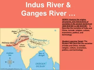
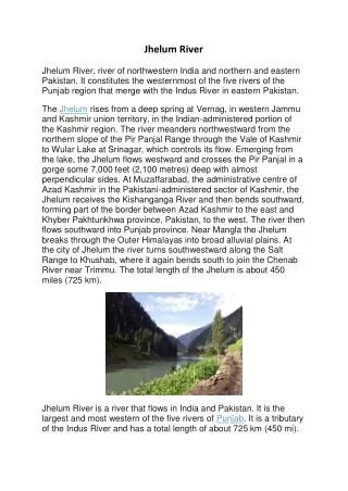
Jhelum River Jhelum River, river of northwestern India and northern and eastern Pakistan. It constitutes the westernmost of the five rivers of the Punjab region that merge with the Indus River in eastern Pakistan. The Jhelum rises from a deep spring at Vernag, in western Jammu and Kashmir union territory, in the Indian-administered portion of the Kashmir region. The river meanders northwestward from the northern slope of the Pir Panjal Range through the Vale of Kashmir to Wular Lake at Srinagar, which controls its flow. Emerging from the lake, the Jhelum flows westward and crosses the Pir Panjal in a gorge some 7,000 feet (2,100 metres) deep with almost perpendicular sides. At Muzaffarabad, the administrative centre of Azad Kashmir in the Pakistani-administered sector of Kashmir, the Jhelum receives the Kishanganga River and then bends southward, forming part of the border between Azad Kashmir to the east and Khyber Pakhtunkhwa province, Pakistan, to the west. The river then flows southward into Punjab province. Near Mangla the Jhelum breaks through the Outer Himalayas into broad alluvial plains. At the city of Jhelum the river turns southwestward along the Salt Range to Khushab, where it again bends south to join the Chenab River near Trimmu. The total length of the Jhelum is about 450 miles (725 km). Jhelum River is a river that flows in India and Pakistan. It is the largest and most western of the five rivers of Punjab. It is a tributary of the Indus River and has a total length of about 725 km (450 mi).
In its course this river takes the form of a stream, which is a lovely site for camping in the trekking. Jhelum River originates from a spring at Verinag, which is at the foot of Pir Panjal in the south-eastern part of Kashmir Valley. It then flows through Srinagar and Wular Lake and enters Pakistan through a deep ravine. The largest tributary of the Jhelum is the Kishenganga (Neelum) River, which joins near Muzaffarabad and enters into the Punjab. The Jhelum River receives the Kishanganga River at Muzaffarabad, the administrative centre of the Pakistani-administered sector of Kashmir, and then bends southward, forming part of the border between Pakistani-administered sector of Kashmir to the east and Khyber Pakhtunkhwa province, Pakistan, to the west. The river then flows into Punjab province to the south. The Jhelum River breaks through the Outer Himalayas near Mangla, forming broad alluvial plains. The river turns southwestward at Jhelum, following the Salt Range to Khushab, where it bends south again to join the Chenab River near Trimmu. The Jhelum is about 450 miles long in total (725 km). Up to the Line of Control (LOC), where it enters Pakistan, the total catchment area is about 15,856 km2. Appreciate