Texas Instream Flow Studies: Technical Overview
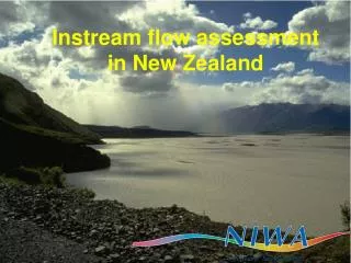
Texas Instream Flow Studies: Technical Overview. Wendy Gordon, Ph.D. Texas Commission on Environmental Quality. October 2006. The Context of Instream Flow Science. Acknowledgment of the importance of water flowing in a stream to fish, wildlife and people

Texas Instream Flow Studies: Technical Overview
E N D
Presentation Transcript
Texas Instream Flow Studies:Technical Overview Wendy Gordon, Ph.D. Texas Commission on Environmental Quality October 2006
The Context of Instream Flow Science • Acknowledgment of the importance of water flowing in a stream to fish, wildlife and people • Acknowledgment that competing uses of water have resulted in degraded river ecosystems • The challenge of developing methods to quantify environmental or instream flow needs
Paradigm Shift in Instream Flow Recommendations • 1950s-70s development of first instream flow methods yielding single minimum flow • Growing recognition of role of natural flow regimes: magnitude, duration, frequency, timing, rate of change • Recent shift to consideration of entire flow regime: subsistence, base, high flow pulses, overbank
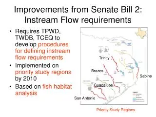
Senate Bill 2 In 2001, the Texas Legislature directed TCEQ, TPWD & TWDB to: • Establish data collection and evaluation program • Determine flow conditions necessary tosupport a sound ecological environmentin Texas rivers and streams • Complete priority studies by December 31, 2010
Legislative Directive “…conduct studies and analyses to determine appropriate methodologies for determining flow conditions in the state’s rivers and streams necessary to support a sound ecological environment.”
State drafted its methodology • State contracted with NRC to peer review program • Members included TNC’s Brian Richter • Report published in 2005
Instream Flow Components (recommended by National Research Council 2005)
Statewide Goal: Support a Sound Ecological Environment “A resilient, functioning ecosystem characterized by intact, natural processes, and a balanced, integrated, and adaptive community of organisms comparable to that of the natural habitat of a region."
Ecosystem Diversity Biotic Provinces River Basins
Interdisciplinary Effort • Summary of the State of Knowledge • Develop Conceptual Model & • Tie Knowledge to Flow Components • Identify and Prioritize Knowledge Gaps • Develop Prioritized Research Agenda Study Design
Steps in TIFP Sub-Basin Studies Reconnaissance and Information Evaluation Stakeholder Input Stakeholder Input Goal Development Consistent with Sound Ecological Environment Peer Review Study Design Multidisciplinary Data Collection and Evaluation Stakeholder Input Peer Review Data Integration to Generate Flow Conditions Stakeholder Input Draft Study Report Stakeholder Input Peer Review Final Study Report SB2 ends Post SB2 Next Steps: Implementation, Monitoring, and Adaptive Management
Sound Ecological Environment Subsistence Flows Base Flows High Flow Pulses Overbank Flows Conserve biological function Conserve biological / habitat diversity and water quality Life history / geomorphic processes Floodplain maintenance • Water quality • tolerances met • Key habitat • thresholds maintained • Habitat for flow • dependent species • Bank storage/moisture • Suitable temperatures / • dissolved oxygen • Fish spawning cues • Maintain channel • Sediment/nutrient • transport • Moisture and nutrients • to floodplain • Riparian recruitment Simple Conceptual Model
Study Design • Incorporate conceptual model of system • Determine geographic scope of study • Prioritize data deficiencies • Develop basin-specific interdisciplinary study plan
Steps in TIFP Sub-Basin Studies Reconnaissance and Information Evaluation Stakeholder Input Stakeholder Input Goal Development Consistent with Sound Ecological Environment Peer Review Study Design Multidisciplinary Data Collection and Evaluation Stakeholder Input Peer Review Data Integration to Generate Flow Conditions Stakeholder Input Draft Study Report Stakeholder Input Peer Review Final Study Report SB2 ends Post SB2 Next Steps: Implementation, Monitoring, and Adaptive Management
Primary Disciplines Physical Processes (Geomorphology) Hydrology & Hydraulics Connectivity Biology Water Quality
Biology • Examine integrity of biological community • Examine biodiversity within ecosystem • Assess habitat-flow relationships
Biology Biodiversity Habitat Diversity
Water Quality • Identify constituents of concern • Assess low flow-water quality relationship • Conduct water quality modeling studies
Water Quality • Dissolved oxygen • pH • Temperature • Total dissolved solids • Turbidity/clarity • Nutrients
Hydrology & Hydraulics • Calculate flow statistics • Describe Wet, Normal, & Dry conditions • Model hydraulic characteristics
Hydraulic and Habitat Modeling Habitat changes with flow
Physical Processes (Geomorphology) • Assess bedforms, banks, and floodplains • Assess active floodplain and channel processes • Assess channel adjusting and overbank flow behavior • Develop sediment budgets • Identify habitat features
Watershed area determined by drainage divide. Determines the boundary conditions within which rivers operate. Watershed Topographic unit determined on the basis of local relief, valley slope and morphology. Defines the valley-setting. Landscape Unit Length of channel with a characteristic assemblage of geomorphic units. River Style Instream and floodplain landforms (pools, bars, levees, backwaters, etc.) that reflect distinct form-process associations. Geomorphic Unit Uniform patches of flow and substrate material within a geomorphic unit. Hydraulic Unit Individual elements (e.g., logs, rocks, gravel patches) within a stream. Microhabitat River Styles Hierarchy
Namoi River Basin, New South Wales Watershed 0 100 300 400 200 Kilometers
Namoi River Basin, New South Wales Watershed Landscape Unit 50 0 25 100 Kilometers Legend – Landscape Units Liverpool plains Pillaga outwash Lowland plains Rugged metasediments Mid to lower Peel Rugged volcanics Pillaga Uplands
Watershed Landscape Unit River Style Middle Namoi Sub-basin 50 0 25 Kilometers
Landscape Unit Uplands Escarpment Base of the Escarpment Rounded Foothills Lowland Plain Channel Slope Channel and Valley Width Planform Valley Cross Section Head-water Cut & Fill (Incised) Vertically Accreated Floodplain Floodplain Accumulation River Style Floodout Cut & Fill (Intact) Fan Throughput Transfer Gorge
Geomorphic Unit Microhabitat Hydraulic Unit Trailing Vegetation Backwater Rippled flow on cobbles Submerged Macrophyte Riffle Barely perceptible flow on sand Cobbles Smooth surface flow on cobbles/sand Floodplain Large Woody Debris Pool Smooth surface flow on cobbles Bar Run Secondary Channel Boulders Sand Pool Leaf Pack Barely perceptible flow on sand/boulders
Connectivity • Hydrologic connectivity • Upstream to down • Channel to floodplain • Groundwater/surface water interactions
Steps in TIFP Sub-Basin Studies Reconnaissance and Information Evaluation Stakeholder Input Stakeholder Input Goal Development Consistent with Sound Ecological Environment Peer Review Study Design Multidisciplinary Data Collection and Evaluation Stakeholder Input Peer Review Data Integration to Generate Flow Conditions Stakeholder Input Draft Study Report Stakeholder Input Peer Review Final Study Report SB2 ends Post SB2 Next Steps: Implementation, Monitoring, and Adaptive Management
Subsistence Flows Identify Biological Considerations Identify Water Quality Constituents of Concern Calculate Low Flow Statistics Conduct Water Quality Modeling Studies Assess Low Flow - Water Quality Relationship Other Biological Considerations Primary Discipline Hydrology/Hydraulics Biology Geomorphology Water Quality Subsistence Flows
Base Flows Assess Bedform and Banks Identify Biological Issues and Key Species Calculate Base Flow Statistics Collect Biological Data Model Hydraulic Characteristics in Relation to Flow Determine Habitat Criteria Assess Habitat-Flow Relationships, including Diversity Describe Wet, Normal, and Dry Years Consider Biological and Riparian Issues Consider Water Quality Issues Primary Discipline Hydrology/Hydraulics Biology Geomorphology Water Quality Base Flows
Assess Active Channel Processes Develop Sediment Budgets Assess Channel Adjusting Flow Behavior Calculate High Flow Statistics Consider Water Quality Issues Describe Significant Habitat Conditions Consider Biological Issues Primary Discipline Hydrology/Hydraulics Biology Geomorphology Water Quality High Flow Pulses High Flow Pulses
Calculate Flood Frequency Statistics Assess Active Floodplain and Channel Processes Model Extent of Flood Events Assess Overbank Flow Behavior Consider Biological Issues Conduct Riparian Studies Consider Water Quality Issues Estimate Riparian Requirements Primary Discipline Hydrology/Hydraulics Biology Geomorphology Water Quality Overbank Flows Overbank Flows
Integration of Flow Components Wet year Average year Dry year 4,000-10,000 cfs for 2-3 days Once every 3-5 years Channel Maintenance Riparian Connectivity, Seed dispersal Flooplain habitat Overbank Flows 700-1500 cfs for 2-3 days 2-3 X per year every year Sediment transport Lateral connectivity Fish spawning 1800 cfs for 2 days 1 X per yr every other year “Big River fish” spawning between Jul 15 - Aug 15 High Flow Pulses 300-450 cfs maintain biodiversity and longitudinal connectivity Base Flows 100-150 cfs Fish habitat 150-300 cfs Spring spawning 40-50 cfs Fish habitat 90-100 cfs Fish habitat Subsistence Flows 35 - 55 cfs Maintain water quality (35 cfs) and key habitats in May (55 cfs) JAN FEB MAR APR MAY JUN JUL AUG SEP OCT NOV DEC
Projects Funded for SB2 • Field-Based Mapping in support of a Geomorphic Analysis of the Lower San Antonio River Subbasin • GIS-Based Geomorphic Analysis of the Lower San Antonio River Subbasin • Field-Based Analysis in support of a Geomorphic Assessment of the Brazos & Navasota River Subbasin • Geomorphic Equilibrium in Southeast Texas Rivers • Distributional Survey and Habitat Utilization of Freshwater Mussels • Developing a Large Woody Debris Budget for the Sabine River, TX • Historical Zoogeography And Abundance Of Fishes In Two Texas River Basins With An Annotated Species List • Assessment of Hydrologic Alteration Software • Geomorphic Studies of the Lower Brazos and Navasota Rivers • Analysis of Existing Biological Data • Biological Sampling on the Lower Brazos River, Sabine River, and San Antonio River (3 separate contracts) • Stakeholder Process
Additional Questions & Comments • Contact: • Wendy Gordon, TCEQ, 512-239-4174 wgordon@tceq.state.tx.us • Kevin Mayes, TPWD, 512-754-6844, ext. 25 Kevin.mayes@tpwd.state.tx.us • Mark Wentzel, TWDB, 512-936-0823 Mark.wentzel@twdb.state.tx.us http://www.twdb.state.tx.us/instreamflows/index.html