How Accurate is Drone Mapping
0 likes | 4 Views
Drone mapping accuracy varies greatly depending on factors, but with the right techniques and equipment, it can achieve centimeter accuracy. Aerial mapping drone systems achieve terrain previously only possible with boots, sticks, and humans looking for humans. With todayu2019s software, such as Pix4D, drone display, and ESRI ArcGIS capabilities, you not only get beautiful speeds, but you also get real, usable maps. Read the full blog to get more information.

How Accurate is Drone Mapping
E N D
Presentation Transcript
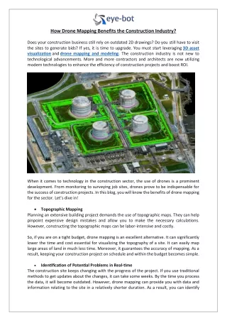
How Accurate is Drone Mapping? Exploring the Latest Tech Innovations in Aerial Survey Solutions Let’s be honest: in the world of construction, utilities, development, and infrastructure, you can’t afford to guess. Whether you’re measuring a grading site, evaluating stockpile volumes, or planning your next major development, accuracy isn’t optional—it’s everything. That’s where drone mapping steps in. And not just any drone mapping—today’saerial mapping dronesystems are achieving accuracy levels once only possible with boots, poles, and hundreds of man-hours. But how accurate is it? And what can it mean for your projects? Let’s take a closer look—because you deserve clarity from the sky down.
Drone Mapping Accuracy—More Than Just “Close Enough” The myth? That drone mapping services are “good enough” for marketing shots but not for real measurements. The truth?Drone survey solutionstoday are achieving centimeter-grade, survey-level accuracy when done right. At BEAD, we use RTK (Real-Time Kinematic) and PPK (Post-Processed Kinematic) technology that allows our drones to tie imagery directly to ground control points (GCPs) or live GNSS correction networks, delivering: •Sub-inch horizontal resolution •2–5 cm vertical accuracy •Survey-grade data outputs for CAD, GIS, and civil workflows And with today’s software like Pix4D, Drone Deploy, and ESRI ArcGIS integrations, you don’t just get beautiful images—you get real, usable maps. Also Read:LiDAR Technology: The Key to Accurate 3D Mapping and Modeling.
Why It Matters for You? Suppose you are trying to decide between a civil engineer, a utility asset manager, or a site planner who is trying to decide from Topo data, stockpile volume, or elevation model. Every inch matters. Every angle counts. Every delay costs. With the right drone mapping technology, you can: •Skip multi-day ground survey setups •Access precise measurements in 48–72 hours •Eliminate human risk in hazardous or remote terrain •Integrate directly into your existing workflows Our clients have reported up to60%-time savingsandthousands in rework avoidanceusing our drone survey solutions.
Innovation You Can Trust from Above Here’s the beauty ofdrone mapping technologytoday: it doesn’t just show you what’s there—it empowers you to see what’s possible. From3D terrain modelstoOrtho mosaics,volume analysistoreal-time overlays, aerial mapping drones are now the gold standard for progress tracking, QA/QC, and project planning. We’ve seen it firsthand—on rail corridors, solar fields, construction zones, and beyond. Still Wondering If It’s “Accurate Enough?” Ask yourself this: Would you trust your next development phase, budget estimate, or safety report to guesswork? Or would you rather have verified, scalable, geospatial data captured with less risk and more precision? AtBirds Eye Aerial Drones, we don’t just offerdrone mapping services—we deliverpeace of mindthrough proven, cutting-edge technology, led by experienced professionals who treat your project like our own.
Let’s Map Smarter—Together. If you are ready to guess from your next project, we are here to help you move forward with confidence, accuracy, and speed. Serving all of California | FAA-Certified | Veteran-Owned BirdsEyeAerialDrones.com