Download
1 / 16
160 likes | 289 Views
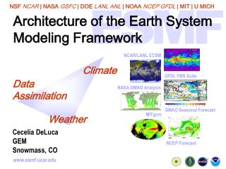
University of São Paulo - USP Institute of Astronomy, Geophysics and Atmospheric Science - IAG Laboratory of Climate and Biosphere - LCB. Development of a set of surface data for modeling the earth system Carlos Eduardo Fagiolo - Meteorologist.

E N D
University of São Paulo - USPInstitute of Astronomy, Geophysics and Atmospheric Science - IAGLaboratory of Climate and Biosphere - LCB Development of a set of surface data for modeling the earth system Carlos Eduardo Fagiolo - Meteorologist
Carbon Tracker and Water availability: controls of Land Use and Climate ChangesProf. Humberto Ribeiro da RochaCoordinator A Consortium of
Objectives The proposal seeks to estimate and interpret greenhouse gases (GHG) and surface hydrological exchanges at large and regional scale in Brazil, both due to climate variation and land use changes (LUC), using consistent field measurements and modelling of the land-atmosphere system. We aim to answer: - if the Amazon basin operates as a sink or source of GHG, which intrinsically adds much uncertainty in the assessment of long term predictions of regional climate; - on what extension the LUC reduces the water availability, and how it might combine future global climate changes; - where and how the medium term policies of adaptation to climate change could be tackled in critical areas
General goals a) developing spatio-temporal distributions of carbon fluxes, estimating mean net carbon flux for Amazon basin (sink or source), using a computational & field data assimilation system – the Carbon tracker, that includes LUC and the aerosol effects; b) emphasizing the strong link between GHG with the hydrological cycle, and calculating changes in water status and ecosystem productivity in the Amazon basin, for a range of climate scenarios; c) estimating surface water and carbon fluxes across several ecosystems in Amazonia, Cerrado and Atlantic Forest, using observation in flux tower sites; d) assessing the hidrological effects of land use changes, for a range of climate change scenarios, in meso-scale watersheds in the biomes of Cerrado and Atlantic Forest.
Figure 1. Pictures of flux towers over Tropical forest (Manaus, JiParaná and Santarem) – photos LBA Office, Cerrado Floodplain (Ilha do Bananal) – photo Humberto Rocha
Figure 2. Pictures of flux towers in the state of Sao Paulo over: Atlantic Forest, Cerrado, Sugar Cane, Eucalyptus – photos Humberto Rocha & Helber Freitas.
Figure 3. Measured 10 m soil moisture profile (in m3m-3) beneath tropical forest at km 83 tower site, Santarem, for both the wettest and driest soil moisture measured at each depth. (source: Bruno et al. 2006) Refletometer (FDR) Fraction of Water Withdrawl Bruno et al., Hydrological Processes (2006)
Specific goals: (i) Use of GIS tools for support environmental modeling; (ii) Implementation of the algorithm MAPPER (Sellers et al. 1994) for estimating biophysical parameters of vegetation obtained from sensors on satellites;(iii) Construction of calibration routines of the models using nonlinear optimization techniques; Tasks: (1) Survey, acquisition and processing topographic data (Digital Elevation Model), maps of vegetation, soil, drainage network, satellite data/images and meteorological data available for spatial domain of watersheds of interest; (2) Data storage, cut towards the areas of drainage basins, transformation between coordinate systems and projections for a standard system, re-sampling and interpolation of data into a unified spatial resolution; (3) Data assimilation of spectral vegetation indices and the derivation of biophysical parameters using the algorithm MAPPER to force the model DBHM; (4) Construction of optimization routines (in Fortran) for model calibration SiB2 for the experimental sites;
Data for theDistributedBiosphereHydrologicalModel (DBHM)(Tang, 2006)
Example of data processed by GIS tools (ArcGis): Land Use Map on the State of Sao Paulo
Two examples of data processed by programming R language: Modis product MCD15A2 – LAI;FPAR – 1km – 8 days – FPAR (maximum, mean, minimum, difference/anomalies) The R Project for Statistical Computing - http://www.r-project.org/ R is a free software environment for statistical computing and graphics. It compiles and runs on a wide variety of UNIX platforms, MacOS and Windows.
...andthe R, onthesameModisproduct, – LAI on Cerrado (Pé de Gigante – PDG, 07/2002 – 09/2010)
Some References Avissar R., R. Silva Dias P. L., Dias M., Nobre C. A., The Large-Scale Biosphereatmosphere Experiment in Amazonia LBA): Insights and future research needs, Journal of Geophysical Research, vol. 107, D20, 8086, 2002 Baker,I.T.,L.Prihodko,A.S.Denning,M.Goulden,S.Miller,H. R. da Rocha (2008). Seasonal drought stress in the Amazon: Reconciling models and observations, J. Geophys. Res., 113, G00B01, doi:10.1029/2007JG000644. Borma, L. S., H. R. da Rocha, O. M. Cabral, C. von Randow, E. Collicchio, D. Kurzatkowski, P. Brugger, H. C. Freitas, R. Tannus, L. Oliveira, C. Renno, and P. Artaxo (2008),Atmospheric and Hydrological Controls of the Evapotranspiration over a Floodplain Forest in the Bananal Island Region, Amazonia,J. Geophys. Res., doi:10.1029/2007JG000641, in press GOULDEN, M. ; MILLER, S. ; da Rocha, H. R. ; MENTON, M. ; FREITAS, H. C. . Physiological controls on tropical Forest CO2 exchange. Ecological applications, EUA, v. 14, n. 4, p. S42-S54, 2004 Miller, S.D., M.L. Goulden, M.C. Menton, H.R. da Rocha, H.C. Freitas, A.M.S Figueira, C.A.D. Sousa. 2004. Biometric and micrometeorological measurements of tropical forest carbon balance. Ecological Applications, V14, N4: S114-126. Miller, S. ; GOULDEN, M. ; da Rocha, H. R. . The effect of canopy gaps on subcanopy ventilation and scalar fluxes in a tropical forest. Agricultural and Forest Meteorology, v. 142, p. 25-34, 2007 Oliveira, P. H. F., P. Artaxo, C. Pires, S. De Lucca, A. Procopio, B. Holben, J. Schafer, L. F. Cardoso, S. C. Wofsy, and H. R. Rocha (2007), The effects of biomass burning aerosols and clouds on the CO2 flux in Amazonia, Tellus, 59B, 338-349, doi:10.1111/j.1600-0889.2007.00270.x. Rocha, H. R. da, P.J. Sellers, J.G. Collatz, I.R. Wright, J. Grace, 1996b. Calibration and use of the SiB2 model to estimate water vapour and carbon exchanges in the Abracos' forest sites. in Amazon Deforestation and Climate, eds. J.C.H. Gash, C.A. Nobre, J.M. Roberts and R. Victória. John Wiley and Sons, Chichester, UK, p. 459-472. Rocha, H. R. ; NOBRE, C. A. ; BONATTI, J. P. ; WRIGHT, I. R. ; SELLERS, P. J. . A vegetation-atmosphere interaction study for amazonian deforestation using field data and a single column model. . Quarterly Journal of the Royal Meteorological Society, (no prelo), v. 122, p. 567-598, 1996. Rocha, H. Freitas, R. Rosolem, R.Juarez, R.N. Tannus, M.V. Ligo, O.M.R.Cabral & M.A.F.Silva Dias 2002. Measurements of CO2 exchange over a woodland savanna (Cerrado Sensu stricto) in southeast Brasil. Biota Neotropica, Vol 2(1). Rocha, H. R. ; FREITAS, H. C. ; PINTO, L. D. V. O. ; MENTON, M. ; GOULDEN, M. ; MILLER, S. ; FIGUEIRA, . Seasonality of water and heat fluxes over a tropical forest in eastern Amazonia. Ecological applications, EUA, v. 14, n. 4, p. S22-S32, 2004 Rocha, H. R., Antonio O. Manzi , Osvaldo Cabral , Scott Miller , Michael Goulden , Scott Saleska , Natalia Coupe, Steven Wofsy , Laura Borma et al (2008). Patterns of water and heat flux across a biome gradient from tropical forest to savanna in Brazil. Journal of Geophysical Research- Biogeosciences (accepted) Saleska, S.R., S. Miller, D. Matross, M. Goulden, S. Wofsy, H. Rocha, P. Camargo, P. Crill, B. Daube, H.Freitas, L. Hutyra, M. Keller, V. Kirchoff, M. Menton, J. Munger, E. Pyle, A. Rice, H. Silva. 2003. Carbon in Amazon forests: unexpected seasonal fluxes and disturbance-induced losses. Science (in press). Sellers, P. J., S.O.Los, C.J.Tucker,C.O.Justice, D.A.Dazlich, C.J. Collatz, D.A., 1996b. A revised land surface parameterization (SiB2) for atmospheric GCMs, Part II: The generation of global fields of terrestrial biophysical parameters from satellite data. J. Climate, 9, 706-737 Tang, Q., Taikan, O., Shinjiro, K. A Distributed Biosphere Hydrological Model (DBHM) for large river basin. Annual Journal Hydraulic Engineering, JSCE, v.50, 1-6, 2006
Those who nothear the music think the dancer is mad That´s all ... folks Thank you !!!