Download
1 / 13
150 likes | 363 Views
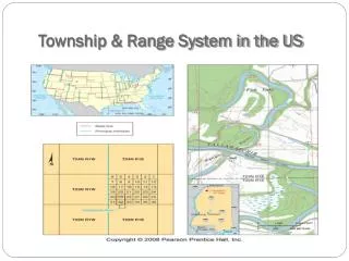
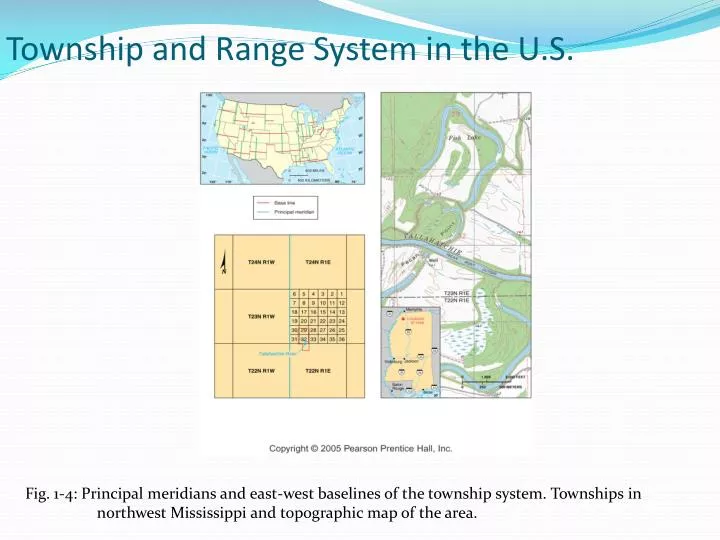
Township and Range System in the U.S. Fig. 1-4: Principal meridians and east-west baselines of the township system. Townships in northwest Mississippi and topographic map of the area. Layers of a GIS.

E N D
Township and Range System in the U.S. Fig. 1-4: Principal meridians and east-west baselines of the township system. Townships in northwest Mississippi and topographic map of the area.
Layers of a GIS Fig. 1-5: A geographic information system (GIS) stores information about a location in several layers. Each layer represents a different category of information.
Place Names • Toponym is the given name of a place Types of Toponyms • For a person • Religion • Landscape/physical features • Names can change • Cincinnati, OH • Truth or Consequence
Site • Physical character of a place • Climate, water sources, topography, soil, vegetation, latitude, and elevation • Site factors have been essential in selecting locations for settlements • Humans can modify the characteristics of a site
Site: Lower Manhattan Island Fig. 1-6: Site of lower Manhattan Island, New York City. There have been many changes to the area over the last 200 years.
Situation • The location of a place relative to other places • Can help us find unfamiliar places • Helps us understand the importance of a location
Situation: Singapore Fig. 1-7: Singapore is situated at a key location for international trade.
Mathematical Location • Latitude (N/S) • Parallels • Equator • Longitude (E/W) • Meridians • Prime Meridian runs through Greenwich, England • Which is important in calculating time??
World Geographic Grid Fig. 1-8: The world geographic grid consists of meridians of longitude and parallels of latitude. The prime meridian (0º) passes through Greenwich, England.
World Time Zones Fig. 1-9: The world’s 24 standard time zones are often depicted using the Mercator projection.