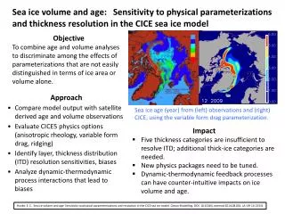
Download
1 / 94
960 likes | 1.2k Views
Drifting Continents. OBJECTIVE. Describe early evidence that led people to suggest that Earth’s continents may have once been joined. Identify evidence of continental drift. Explain why continental drift was not accepted when it was first proposed. Vocabulary continental drift Pangaea.

E N D
Drifting Continents OBJECTIVE • Describe early evidence that led people to suggest that Earth’s continents may have once been joined. • Identify evidence of continental drift. • Explain why continental drift was not accepted when it was first proposed. Vocabulary • continental drift • Pangaea
Drifting Continents Drifting Continents • Earth’s surface appears to remain relatively unchanged during the course of an average human lifetime. • On the geologic time scale, Earth’s surface is changing at rates almost too great to imagine.
Drifting Continents Early Observations • In the late 1500s, Abraham Ortelius, a Dutch mapmaker, noticed the apparent fit of continents on either side of the Atlantic Ocean. • In the late 1800s, Eduard Suess, an Austrian geologist, hypothesized that the present southern continents had once been joined as a single landmass that he named Gondwanaland.
Drifting Continents Early Observations • The first time that the idea of moving continents was proposed as a serious scientific hypothesis was in 1912 by a German scientist named Alfred Wegener. • He proposed that the continents had moved, or drifted, from one location to another over time.
Drifting Continents Continental Drift
Drifting Continents Continental Drift • Wegener’s hypothesis, continental drift, proposed that Earth’s continents had once been joined as a single landmass. • Wegener proposed that Pangaeabegan to break apart about 200 million years ago. • Pangaea, a Greek word that means “all the earth,” refers to the combined landmass.
Drifting Continents Continental Drift
Drifting Continents Continental Drift Evidence from Rock Formations • Wegener reasoned that large geologic structures, such as mountain ranges, would have fractured as the continents separated. • Using this reasoning, Wegener hypothesized that there should be areas of similar rock types on opposite sides of the Atlantic Ocean. • That similar groups of rocks were observed in the United States, Greenland, and Europe supported Wegener’s idea.
Drifting Continents Continental Drift Evidence from Rock Formations
Drifting Continents Continental Drift Evidence from Fossils • Similar fossils of several different animals and plants that once lived on land had been found on widely separated continents. • The ages of different fossils predated Wegener’s time frame for the breakup of Pangaea. • Fossils of Glossopteris, a seed fern that resembled low shrubs, have been found on many continents, indicating that the areas had a single climate that was close to the equator.
Drifting Continents Continental Drift - Evidence from Fossils
Drifting Continents Continental Drift • When did Africa and South America split into separate continents? • Why was the fossil, mesosaurus an important form of evidence for the theory of continental drift?
Drifting Continents Ancient Climatic Evidence • Various sedimentary rocks offer evidence of vast climatic changes on some continents. • Coal deposits in Antarctica suggested that it must have been closer to the equator. • Glacial deposits found in Africa, India, Australia, and South America suggested that these areas had once been covered by thick ice caps. • Wegener proposed that they once were located near the south pole before Pangaea began to fracture.
Drifting Continents Ancient Climatic Evidence
Drifting Continents The Break Up
Drifting Continents A Rejected Hypothesis • In the early 1900s, most scientists rejected Wegener’s hypothesis of continental drift. • Two unanswered questions—what forces could move continents and how continents could move without shattering —were the main reasons that the hypothesis of continental drift was rejected.
Drifting Continents Section Assessment 1. How did Pangaea differ from the present layout of the continents? During Pangaea, the continents were joined and essentially located in one hemisphere from the north to the south poles. Presently, the continents have separated and are distributed in both the eastern and western hemisphere, with the majority of landmass in the northern hemisphere.
Drifting Continents Section Assessment 2. According to Wegener, what force caused the continents to move? Wegener suggested that the rotation of Earth could be responsible for continental movement.
Drifting Continents Section Assessment 3. Identify whether the following statements are true or false. ______ Similar rock types are located in South America and Africa. ______ Gondwanaland and Pangaea essentially refer to the same thing. ______ Coal located in India and Africa suggest that they were once located in warmer climates. ______ Geologic evidence suggests that North America, Greenland, and Europe were once connected. True True False True
Deriva Continental • La idea de que los continentes, sobre todo Sudamérica y África, encajan como piezas de un rompecabezas, se origino con el desarrollo de mapa mundiales razonablemente precisos. • Se dio poca importancia a esta noción hasta 1915 cuando Alfred Wegener, meteorólogo y geólogo alemán publico El origen de los continentes y los océanos. • Wegener estableció el esbozo básico de su radical hipótesis de la deriva continental.
Deriva Continental • Wegener sugirió que en el pasado había existido un supercontinente único denominado Pangea (pan = todo, gea = Tierra).
Seafloor Spreading Objectives • Summarize the evidence that led to the discovery of seafloor spreading. • Explain the significance of magnetic patterns on the seafloor. • Explain the process of seafloor spreading. Vocabulary • magnetometer • paleomagnetism • magnetic reversal • isochron • seafloor spreading
Seafloor Spreading Seafloor Spreading • Until the mid-1900s, most people, including many scientists, thought that the ocean floor, unlike the continents, was essentially flat. • Many people also had the misconceptions that oceanic crust was unchanging and was much older than continental crust. • Advances in technology during the 1940s and 1950s, however, proved all of these widely accepted ideas to be wrong.
Seafloor Spreading Help from Technology • The development of echo-sounding methods allowed scientists to study the ocean floor in great detail. • Sonar uses sound waves to measure water depth by measuring the time it takes for sound waves to travel from the device and back to a receiver.
Seafloor Spreading Help from Technology • A magnetometer is a device that can detect small changes in magnetic fields, allowing scientists to construct magnetic maps of the seafloor.
Seafloor Spreading Ocean Floor Topography • The maps made from the data collected by sonar and magnetometers showed underwater mountain chains called ocean ridges. • The same data showed that these underwater mountain chains have counterparts called deep-sea trenches. • These two topographic features of the ocean floor puzzled geologists for over a decade after their discovery.
Seafloor Spreading Ocean Rocks and Sediments • Analysis of deep-sea rocks and sediments produced two important discoveries. 1. The ages of the rocks that make up the seafloor vary in different places, and that the age of oceanic crust consistently increases with distance from a ridge. • The oldest part of the seafloor is geologically young at about 180 million years old. 2. The thickness of ocean-floor sediment was, in general, much less than expected and that the thickness of the sediments increases with distance from an ocean ridge.
Seafloor Spreading Ocean Rocks and Sediments
El Campo Magnético de la Tierra • Cualquiera que haya utilizado una brújula para orientarse sabe que el campo magnético de la Tierra tiene un polo norte y un polo sur magnéticos. • Líneas de fuerza invisibles atraviesan el planeta y se extienden de un polo magnético al otro. • Ciertas rocas contienen minerales que sirven como brújulas fósiles. Estos minerales ricos en hierro, son abundantes en las coladas de lava de composición basáltica.
El Campo Magnético de la Tierra • Cuando se calientan por encima de una temperatura conocida como el punto de Curie, estos minerales magnéticos pierden su magnetismo. • Sin embargo, cuando esos granos rico en hierro se enfrían por debajo de su punto de Curie (aproximadamente 585 ºC para la magnetita) se magnetizan de manera según una dirección paralela a las líneas de fuerzas magnéticas existentes en ese momento.
Seafloor Spreading Magnetism • Rocks containing iron-bearing minerals provide a record of Earth’s magnetic field. • Paleomagnetism is the study of Earth’s magnetic record. • Basalt, because it is rich in iron-bearing minerals, provides an accurate record of ancient magnetism.
Seafloor Spreading Magnetism The Geomagnetic Time Scale • Studies of continental basalt flows in the early 1960s revealed a pattern of magnetic reversals over geologic time. • A magnetic reversal is a change in Earth’s magnetic field. • A magnetic field that is the same as the present has normal polarity. • A magnetic field that is opposite to the present has reversed polarity.
Seafloor Spreading Magnetism The Geomagnetic Time Scale • Towing magnetometers behind ships to measure the magnetic field of the ocean floor revealed an interesting pattern. • In places where the magnetic readings of the ocean floor matched Earth’s present field, a stronger-than-normal reading (+) was recorded. • In places where the magnetic data were reversed in relation to Earth’s present magnetic field, a lower-than-normal reading (–) was recorded.
Seafloor Spreading Magnetism The Geomagnetic Time Scale
Seafloor Spreading Magnetism Magnetic Symmetry • The positive and negative areas of the seafloor form a series of stripes that were parallel to ocean ridges. • The magnetic pattern on one side of the ridge is a mirror image of the pattern on the other side of the ridge.
Seafloor Spreading Magnetism Magnetic Symmetry • The magnetic data collected from the ocean floor matched the pattern of magnetic reversals that had been found in basalt flows on land. • From this match, scientists were able to determine the age of the ocean floor from a magnetic recording and quickly create isochron maps of the ocean floor. • An isochron is a line on a map that connects points that have the same age.
Seafloor Spreading Magnetism
Seafloor Spreading Seafloor Spreading • An American scientist named Harry Hess proposed the theory of seafloor spreading. • Seafloor spreading states that new ocean crust is formed at ocean ridges and destroyed at deep-sea trenches. • Magma is forced toward the crust along an ocean ridge and fills the gap that is created.
Seafloor Spreading Seafloor Spreading • When the magma hardens, a small amount of new ocean floor is added to Earth’s surface. • Each cycle of spreading and the intrusion of magma results in the formation of another small section of ocean floor, which slowly moves away from the ridge.
Seafloor Spreading Seafloor Spreading The Missing Link • Seafloor spreading was the missing link needed by Wegener to complete his model of continental drift. • Continents are not pushing through ocean crust, as Wegener proposed; they ride with ocean crust as it slowly moves away from ocean ridges.
Seafloor Spreading Section Assessment 1. Match the following terms with their definitions. ___ magnetometer ___ paleomagnetism ___ isochron ___ seafloor spreading A. a device that can detect small changes in magnetic fields B.a line on a map that connects points that have the same age C.the study of Earth’s magnetic record D. a theory that states that new ocean crust is formed at ocean ridges and destroyed at deep-sea trenches A C B D
Seafloor Spreading Section Assessment 2. How does the distribution of ocean-floor sediments support the theory of seafloor spreading? The thickness of ocean-floor sediments increases with distance from an ocean ridge which indicates that the seafloor is older with distance.
Seafloor Spreading Section Assessment 3. Identify whether the following statements are true or false. ______ Earth’s magnetic field has reversed more than 20 times over the past five million years. ______ The oldest part of the seafloor is over 500 million years old. ______ Alfred Wegener first proposed the theory of seafloor spreading. ______ Shale provides an accurate record of ancient magnetism. true false false false
Theory of Plate Tectonics Objectives • Explain the theory of plate tectonics. • Compare and contrast the three types of plate boundaries and the features associated with each. Vocabulary • theory of plate tectonics • divergent boundary • rift valley • convergent boundary • subduction • transform boundary
Theory of Plate Tectonics Theory of Plate Tectonics • The theory of plate tectonics states that Earth’s crust and rigid upper mantle are broken into enormous moving slabs called plates. • There are a dozen or so major plates and several smaller ones. • Tectonic plates move in different directions and at different rates over Earth’s surface.
Theory of Plate Tectonics Theory of Plate Tectonics
Theory of Plate Tectonics Plate Boundaries • Tectonic plates interact at places called plate boundaries. • At some plate boundaries: • Plates come together, or converge • Plates move away from one another, or diverge • Plates move horizontally past one another