Download
1 / 33
330 likes | 334 Views
This project aims to improve the support for high impact sub advisory winter precipitation events along Interstate 80 in Central Pennsylvania. It is a partner project with the Pennsylvania Department of Transportation and the Pennsylvania State Police, led by Gregory A DeVoir from NOAA NWS State College. The goal is to provide better communication and dissemination of crucial information to mitigate the potential impact of these events.

E N D
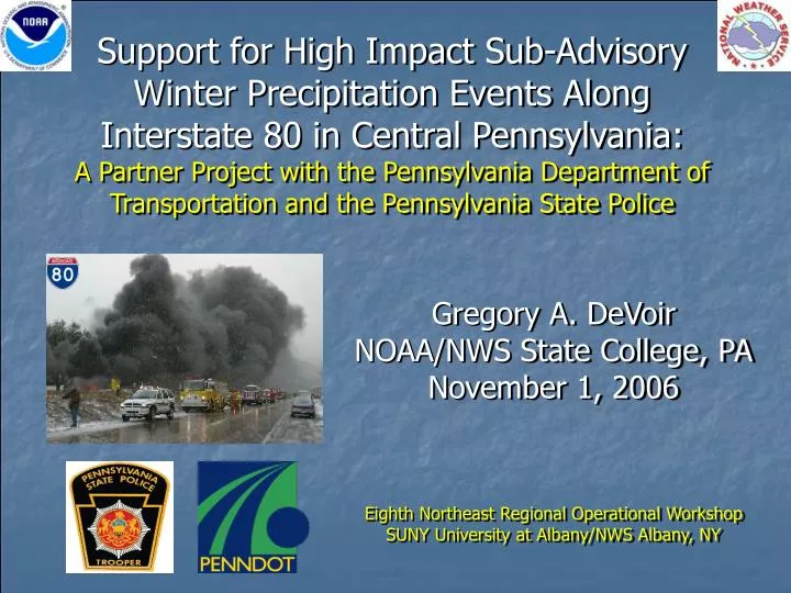
Support for High Impact Sub-Advisory Winter Precipitation Events Along Interstate 80 in Central Pennsylvania:A Partner Project with the Pennsylvania Department of Transportation and the Pennsylvania State Police Gregory A. DeVoir NOAA/NWS State College, PA November 1, 2006 Eighth Northeast Regional Operational Workshop SUNY University at Albany/NWS Albany, NY
References • Billingsley, Rusty, 2006: Role of the SOO in an Evolving NWS. SPoRT Workshop, Huntsville, AL. www.ghcc.msfc.nasa.gov/sport/soo_workshop/ billingsley_soo_conf2006.ppt • Colby, F. P., Jr. and B. Krajewski, 2005: Forecasting Snow Squalls Using Mesoscale Models. 21st Conference on Weather Analysis and Forecasting, Washington, D.C., Amer. Meteor. Soc. • DeVoir, G.A., 2004: High impact sub-advisory snow events: The need to effectively communicate the threat of short duration high intensity snowfall. 20th Conf. Wea. Forecasting, Seattle, WA, Amer. Meteor. Soc. • Eisenberg, Daniel, 2004: The Mixed Effects of Precipitation on Traffic Crashes, University of California Berkeley. • Fridstrom, L., Liver, J., Ingebrigtsen, S., Kulmala, R., Thomsen, L., 1995. Measuring the contribution of randomness, exposure, weather, and daylight to the variation in road accident counts. Crash Anal. Prev. 27 (1), 1–20.
Which of the following snowfalls will have the greatest impact on the public? A. One foot of snow(Winter Storm Warning) B. 6 to 8 inches(Winter Storm Warning) C. 3 to 5 inches(Snow Advisory) D. ½ to 3 inches
What is Impact? • How do we assess it? • Can we quantify or verify it? • Impact is dynamic and depends on any number of constantly changing variables • We may not be able to quantify it, but we all know significant impact when we see it (and so does the media)
Which of the following snowfalls will have the greatest impact on the public? A. One foot of snow(Winter Storm Warning) B. 6 to 8 inches(Winter Storm Warning) C. 3 to 5 inches(Snow Advisory) D. ½ to 3 inches E. It Depends!(on rate of fall, time of year, time of day, day of week, wind speed, surface temps, etc.)
NWS Moving Forward • Shift from: Phenomenon-Based Forecasts to: Impact-Based Forecasts “Ummm…yeaah….if you could go ahead and tell me what sort of impact tomorrow’s snowfall will have on the public, that would be gre-at” • Shift from: Product-based service to: Decision Support Services ConOps: NWS services will change with time. How and when is not currently well defined. Opportunity knocks! Rusty Billingsley – Chief – SR SSD
High Impact Sub-Advisory (HISA) Snowfall • Short duration, high intensity snow (falling in bursts or squalls) with 1-3” amounts in a 1 to 2 hour period, greatly magnifies impact • Instantaneous whiteouts, rapidly changing road conditions and driver anxiety/confusion make chain reaction accidents more likely • The terms “high impact” and “sub-advisory” (HISA) are used here to describe such events
The HISA Problem • On average, throughout the winter months, sub-advisory snowfalls occur 3 to 4 times as often as Snow Advisory and Warning events • When sub-advisory snow impact is high (intensity and timing), information dissemination becomes crucial. • How do we get this information to the people who need it most? • How can we mitigate the potential impact if people don’t receive the information?
The HISA Problem • Predictability constraints • Localized events • Sometimes, but not always predictable more than a few hours in advance • Analogous to severe local convection • “Conditions are favorable for the formation…” • Imminent threats require short fused dissemination to prompt immediate life- and property-saving action
When a squall or snow burst approaches, how do we notify… This guy? And this guy? You and everybody else behind you?
Recent High Impact Sub-Advisory Events in PA • 22 February 2001 – 2 to 3 inches of snow in less than 2 hours throughout central and northern mid-Atlantic states • Numerous chain reaction accidents - 300 vehicle pileup north of Washington D.C. • 28 December 2001 - Lake Effect Snow Squall (Loganton, PA) • 8 Dead • 5 January 2003 – 1 to 3 inches of snow in less than 3 hours across south central PA (midday Sunday - church services)
Arctic Fronts w/Squalls Plunging Post-frontal Sub-freezing Temperatures Above-freezing prefrontal temperatures
Lake Effect Snow Showers and Squalls © geology.com
NOAA Strategic Plan andthe NWS Mission • “Support the Nation’s commerce with information for safe, efficient, and environmentally sound transportation” • NWS Data and services protect life and property, an inherently governmental function, with direct benefit to the national economy
Early Work: NWS State College, PA • Focus on I-80 – and on the most susceptible counties • Immediate notifications • Judicial SPS issuances • Detailed impact statements • NOWCASTs have limited dissemination • Phone calls • Specific county PENNDoT and PSP offices
Early Work • PENNDoT • Intelligent Transportation Systems (ITS) • $$$ • Limited availability/deployment • State Police (PSP)
January 6, 2004 Milesburg, PA CDT PHOTO/MICHELLE KLEIN AP PHOTO CDT PHOTO/MICHELLE KLEIN CDT PHOTO/NIKI DESAUTELS CDT PHOTO/NIKI DESAUTELS Photo Credits: Centre Daily Times (CDT) and AP
January 6, 2004 • A total of 6 dead • A total of 17 injured - Life Flight evacuations • 20 Tractor Trailers and 17 Automobiles involved • Multi-million dollars in damage (estimate not available) • Support from 7 counties, 80 agencies, and over 700 first responders • Response and recovery - 30,000+ man hours. • Outstanding lawsuits – years of litigation
I-80 Notification Plan • Two tiered approach • Long term: • Email notifications (1-2 days in advance) sent to all county PENNDoT and PSP contact points • Short term: • Highly detailed SPSs (issued not only for I-80 area) • Phone Call Chain • 1 phone call originates from WFO State College • PENNDoT Activation of ITS highway signs and Highway Advisory Radio • PSP Support – cruisers dispatched to edge of affected area to run lights, slowing traffic
PAZ012-018-019-045-049-230045-NORTHERN CENTRE-NORTHERN CLINTON-SOUTHERN CENTRE-SOUTHERN CLINTON-UNION-749 PM EDT FRI SEP 22 2006 • ...A SNOW SQUALL WILL AFFECT UNION...CENTRE AND CLINTON COUNTIES...AT 748 PM EDT...NATIONAL WEATHER SERVICE DOPPLER RADAR INDICATED A SNOW SQUALL 12 MILES NORTH OF BELLEFONTE...MOVING EAST AT 30 MPH. THE SQUALL WILL BE NEAR BALD EAGLE STATE PARK...HOWARD AROUND 755 PM...BEECH CREEK AROUND 800 PM...LAMAR...MILL HALL...LOCK HAVEN AROUND 810 PM...MACKEYVILLE...REBERSBURG AROUND 815 PM...LOGANTON AROUND 830 PM AND CARROLL AROUND 835 PM. • THIS WILL IMPACT THE FOLLOWING CENTRAL PENNSYLVANIA INTERSTATES...I-80 BETWEEN MILE MARKERS 165 AND 199.THIS WILL ALSO IMPACT THE FOLLOWING MAJOR ROADS...ROUTE 220...STATE ROAD 45. • THE SNOW WILL RAPIDLY DROP VISIBILITIES IN THE SQUALL TO NEAR ZERO.USE EXTREME CAUTION IF YOU MUST TRAVEL INTO OR THROUGH THISPOTENTIALLY DANGEROUS SNOW SQUALL. CONSIDER DELAYING TRAVEL UNTIL THESQUALL PASSES YOUR LOCATION. • $$
Verification? • OTB thinking • 180 ̊ from conventional NWS verification • No news is good news = mitigation worked! • Transportation departments benefit – better leverage resources - save tax $$
Ongoing and Future Work • Expanding notifications • All counties receive high impact SPSs • I-80 call chain is experimental • Goal to fully automate notifications • Control work load • Foster continued cooperation with PENNDoT and PSP
Ongoing and Future Work • Find event “fingerprints” • Ensembles • Past event reconstructions with mesoscale models • Conducting and applying relational studies to determine parameters necessary to produce squalls in weakly forced environments
Acknowledgements • David Ondrejik – WCM, WFO State College
A few final points • Accidents will happen • High Impact Notifications • Reduce the severity of accidents • Save lives • Decrease property damage
Questions? “Excuse me, I have a question…”