Download
1 / 37
420 likes | 906 Views
Soil Moisture from Remote Sensing: METOP ASCAT Soil Moisture Retrieval. Sebastian Hahn shahn@ipf.tuwien.ac.at. Research Group Photogrammetry and Remote Sensing Department of Geodesy and Geoinformation Vienna University of Technology www.ipf.tuwien.ac.at/radar. Outline.

E N D
Soil Moisture from Remote Sensing:METOP ASCAT Soil Moisture Retrieval Sebastian Hahn shahn@ipf.tuwien.ac.at Research Group Photogrammetry and Remote Sensing Department of Geodesy and GeoinformationVienna University of Technology www.ipf.tuwien.ac.at/radar
Outline • Introduction to Soil Moisture • Microwave properties • Remote Sensing of soil moisture • SMOS • SMAP • METOP ASCAT • TU Wien Soil Moisture Retrieval • Assumption • Processing steps • Limitations • Conclusion
Land Ice Atmosphere Ocean Other
SoilMoisture Source: Koorevaar et al., 1983 • Definition, e.g. • Average Cross-section of a soil Air Water Solid Particles Thin, remotely sensed soil layer Root zone: layer of interest for most applications Soil profile
Microwaves • Microwaves: 1 mm – 1m • Band designations • Advantages compared to optical/IR range • penetrate the atmosphere (to some extent clouds and rain) • independent of the sun as source of illumination • penetration depth into vegetation and soil Source: Ulaby et al., 1981
Transmission through Atmosphere, Clouds and Rain Atmosphere Clouds Rain Source: Ulaby et al., 1981
Microwaves and Water • Microwaves • All-weather, day-round measurement capability • Very sensitive to soil water content below relaxation frequency of water (< 10 GHz) • Penetrate vegetation and soil to some extent • Penetration depth increases with wavelength The dipole moment of water molecules causes “orientationalpolarisation”, i.e. a high dielectric constant Relationship between soil moisture and dielectric constant Source: after Ulaby et al., 1986 Dielectric constant of water Source: Schanda, 1986
Activeand Passive Microwave Sensors • Active • Active remote sensors create their own electromagnetic energy • Sensors • Altimeters • Side-looking real aperture radar • Scatterometer (SCAT) • Synthetic Aperture Radar (SAR) • Passive • Passive remote sensing systems record electromagnetic energy that is reflected or emitted from the surface of the Earth • Sensors • Microwave radiometers Source: Gloersen et al., 1992
Observedquantities • Radars • Backscattering coefficient s0; a measure of the reflectivity of the Earth surface • Radiometers • Brightness temperature TB = e × Ts where e is the emissivity and Ts is the surface temperature • Passive and active methods are interrelated through Kirchhoff’s law: • e = 1 – r where r is the reflectivity • Example: increase in soil moisture content • Backscatter ↑ • Emissivity ↓
Scattering Mechanisms Surface Scattering Source: Ulaby et al., 1982 Volume Scattering Backscatter from Vegetation Surface-volume interaction Volume scattering Surface scattering (attenuated byvegetation canopy) Source: Ulaby et al., 1982 Source: Bartalis, 2009
Microwavemissionsforsoilmoisture • 33 yearsof passive andactivesatellitemicrowaveobservationsforsoilmoisture
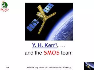
SMOS – SoilMoistureandOceanSalinity • Launched: Nov. 2009 • Passive, L-band, 1.41 GHz, 21.3 cm • V and H polarisation • Spatial Resolution: 30 – 50 km • Swath: 1000 km • Daily global coverage: 82 % • Multi-angular: 30 – 55° • Synthetic Antenna • Several (quasi) instantaneous independent measurements SMOS Source: ESA MIRAS, the Microwave Imaging Radiometer using Aperture Synthesis instrument, is a passive microwave 2-D interferometric radiometer measuring in L-Band; 69 antennas are equally distributed over the 3 arms and the central structure. Source: http://www.cesbio.ups-tlse.fr/SMOS_blog/
SMAP – SoilMoistureActive Passive • Active • Frequency: 1.26 GHz • Polarizations: VV, HH, HV (not fullypolarimetric) • Relative accuracy (3 km grid): 1 dB (HH and VV), 1.5 dB (HV) • Passive • Frequency: 1.41 GHz • Polarizations: H, V, 3rd & 4th Stokes • Relative accuracy (30 km grid): 1.3 K • Spatial Resolution: • Radiometer (IFOV): 39 km x 47 km • SAR: 1-3 km (overouter 70% ofswath) • Swathwidth: 1000 km • Orbit: Polar, Sun-Synchronous SMAP Source: NASA Conically-scanningdeployablemeshreflectorsharedbyradarandradiometer (Diameter: 6 m, Rotation rate: 14.6 RPM) Launch: Nov. 2014
European C-Band Scatterometer • ERS Scatterometers • = 5.7 cm / 5.3 GHz • VV Polarization • Resolution: (25) / 50 km • Daily global coverage: 41% • Multi-incidence: 18-59° • 3 Antennas • Data availability • ERS-1: 1991-2000 • ERS-2: 1995-2011 gaps due to loss of gyros (2001) and on-board tape recorder (2003) • METOP Advanced Scatterometer • = 5.7 cm / 5.3 GHz • VV Polarization • Resolution: 25 / 50 km • Daily global coverage: 82 % • Multi-incidence: 25-65° • 6 Antennas • Data availability • At least 15 years • METOP-A: since 2006
METOP ASCAT ERS-1/2 Source: Bartalis, 2009
TU Wien Change Detection Approach SCAT Measurement
TU Wien Model – Assumptions • Linear relationship between backscatter (in dB) and soil moisture • Empirical description of incidence angle behaviour • Land cover patterns do not change over time • Roughness at a 25/50 km scale is constant in time • Vegetation cycle basically unchanged from year to year • Seasonal vegetation effects cancel each other out at the "cross-over angles" • dependent on soil moisture
TU Wien Model – Processing steps Resampling • Constructing the Discrete Global Grid (DGG) • Adapted sinusoidal grid • Ellipsoid: GEM6 • Discontinuity at 180° meridian AzimuthalNormalisation ESD CalculateSlope andCurvature Incidence angle Normalisation Freeze/Thawdetection Estimationof dry/wetreference Wetcorrection SurfaceSoilMoisture SoilWater Index (SWI)
TU Wien Model – Processing steps Resampling AzimuthalNormalisation ESD CalculateSlope andCurvature time Orbit geometry Incidence angle Normalisation Freeze/Thawdetection Estimationof dry/wetreference Wetcorrection SurfaceSoilMoisture SoilWater Index (SWI) Hammingwindow Source: Naeimi, 2009 andBartalis, 2009
TU Wien Model – Processing steps Resampling AzimuthalNormalisation ESD CalculateSlope andCurvature Incidence angle Normalisation Freeze/Thawdetection Source: Bartalis, 2006 andBartalis, 2009 Estimationof dry/wetreference Wetcorrection SurfaceSoilMoisture SoilWater Index (SWI)
TU Wien Model – Processing steps Resampling Estimated Standard Deviation (ESD) AzimuthalNormalisation ESD CalculateSlope andCurvature Incidence angle Normalisation Freeze/Thawdetection Estimationof dry/wetreference Wetcorrection SurfaceSoilMoisture SoilWater Index (SWI) Source: Naeimi 2009
TU Wien Model – Processing steps Incidence angle – backscatterbehaviourSource: Naeimi, 2009 Resampling AzimuthalNormalisation ESD CalculateSlope andCurvature Incidence angle Normalisation Taylor series (degree 2), expansion point: Freeze/Thawdetection Estimationof dry/wetreference measure curvature slope Wetcorrection SurfaceSoilMoisture SoilWater Index (SWI)
TU Wien Model – Processing steps Resampling AzimuthalNormalisation ESD CalculateSlope andCurvature Incidence angle Normalisation Freeze/Thawdetection Estimationof dry/wetreference Wetcorrection SurfaceSoilMoisture SoilWater Index (SWI) Source: Naeimi, 2009
TU Wien Model – Processing steps Source: Naeimi, 2009 Resampling AzimuthalNormalisation ESD CalculateSlope andCurvature Incidence angle Normalisation Freeze/Thawdetection Estimationof dry/wetreference measure curvature slope Wetcorrection SurfaceSoilMoisture SoilWater Index (SWI)
TU Wien Model – Processing steps Resampling Surface State Flag (SSF) AzimuthalNormalisation ESD CalculateSlope andCurvature Incidence angle Normalisation Freeze/Thawdetection Estimationof dry/wetreference Wetcorrection Naeimi, V., Paulik, C., Bartsch, A., Wagner, W., Member, S., Kidd, R., Park, S., et al. (2012). ASCAT Surface State Flag (SSF): Extracting Information on Surface Freeze/Thaw Conditions From Backscatter Data Using an Empirical Threshold-Analysis Algorithm. IEEE Transactions on Geoscience and Remote Sensing. SurfaceSoilMoisture SoilWater Index (SWI)
TU Wien Model – Processing steps Source: Wagner, 1998 Resampling Cross-over angle concept AzimuthalNormalisation ESD CalculateSlope andCurvature Incidence angle Normalisation Freeze/Thaw detection Estimationof dry/wetref. Wetcorrection SurfaceSoilMoisture SoilWater Index (SWI) Source: Naeimi, 2009
TU Wien Model – Processing steps Resampling AzimuthalNormalisation Dry reference ESD CalculateSlope andCurvature Incidence angle Normalisation Freeze/Thaw detection Estimationof dry/wetref. Wetcorrection Wet reference SurfaceSoilMoisture SoilWater Index (SWI) Source: Naeimi, 2009
TU Wien Model – Processing steps Resampling AzimuthalNormalisation ESD CalculateSlope andCurvature Incidence angle Normalisation Freeze/Thaw detection Estimationof dry/wetreference Wetcorrection SurfaceSoilMoisture SoilWater Index (SWI) Source: Naeimi, 2009 • Problem • In very dry climates the soil wetness does not ever reach to the saturation point
TU Wien Model – Processing steps Resampling • Soil moisture calculated relative to historically driest and wettest conditions (Degree of Saturation) AzimuthalNormalisation ESD CalculateSlope andCurvature Incidence angle Normalisation Freeze/Thaw detection σ Estimationof dry/wetreference Wet correction SurfaceSoilMoisture SSM SoilWater Index (SWI)
TU Wien Model – Processing steps Resampling Mean ERS Scatterometer Surface Soil Moisture (1991-2007) AzimuthalNormalisation ESD CalculateSlope andCurvature Incidence angle Normalisation Freeze/Thaw detection Estimationof dry/wetreference Wet correction SurfaceSoilMoisture SoilWater Index (SWI)
TU Wien Model – Processing steps Resampling • Using the latest x number of surface soil moisture values, calculate the profile soil moisture values using an infiltration model • T...characteristic time length (days) • 1, 5, 10, 15, 20, 40, 60, 100 days AzimuthalNormalisation ESD CalculateSlope andCurvature Incidence angle Normalisation Freeze/Thaw detection Estimationof dry/wetreference SSM Wet correction Surface Soil Moisture SoilWater Index (SWI) SWI
Resuméoftheretrieval • Soil moisture retrieval method is a data-based approach • Starts from the observations, not from theoretical model considerations • Nevertheless, the TU Wien method has a solid physical foundation • Exploits multiple viewing capabilities • Important for modelling the effect of seasonal vegetation growth and decay (phenology) • Exploits the availability of long-term data series • Change Detection Approach: Accounts for heterogeneous land cover and spatial surface roughness patterns • No external/auxiliary datasets are used for the retrieval • Soil texture, soil type, land cover, biomass, evapotranspiration, brightness temperature… • But raw backscattering signatures in different incidence (viewing) angles
Wheredoestheretrievalgowrong? • Low signal-to-noise ratio (known from error propagation) • Vegetation • Mountainous regions • Urban areas • Where does the model fail? • Frozen ground • (Wet) Snow • Water surfaces • Dry soil scattering • Known calibration issues • Wet correction in arid environments • Differences in sensor calibration • Long-term changes in land cover Relative SoilMoisture Noise (%) Source: Naeimi, 2009
ASCAT SoilMoistureProductFamilies • Surface (< 2 cm) soilmoisture (SSM) • 25 km / 50 km in near-real-time (~135 min) in orbitgeometry (EUMETSAT) • 25 km irregularlyupdated off-line time seriesat a fixeddiscrete global grid(H-SAF/TU Wien) • Profile (~2-100 cm) soilmoisture = SoilWater Index (SWI) • 25 km off-line (TU Wien) • 50 km assimilatedsoilmoistureatfixedgridfor Europe (H-SAF/ECMWF) • Downscaled ASCAT-ASAR soilmoisture • 1 km near real-time on fixedgridfor Europe (H-SAF/ZAMG/TU Wien) http://www.eumetsat.int http://hsaf.meteoam.it http://www.zamg.at
ASCAT Dataviewer www.ipf.tuwien.ac.at/radar/dv/ascat/
Conclusion • Soil moisture is currently topic of international agendas • Large and diverse user community • ASCAT offers the first operational soil moisture product distributed by EUMETSAT over EUMETCast • Many positive validation and application studies • Still, product quality can much improved by further developing and improving the algorithms & software • Validation, Intercomparisons and Merging • International Soil Moisture Network • http://www.ipf.tuwien.ac.at/insitu/ • Intercomparisons with SMOS, AMSR-E, SMAP, GLDAS, ERA-Interim, ... • Combined soil moisture products • http://www.esa-soilmoisture-cci.org/
Further Reading Publications Wagner, W., Lemoine, G., Rott, H. (1999): A Method for Estimating Soil Moisture from ERS Scatterometer and Soil Data. Rem. Sens. Environ. 70: 191-207. Wagner, W., Naeimi, V., Scipal, K., de Jeu, R., and Martínez-Fernández, J. (2007): Soilmoisturefrom operational meteorologicalsatellites, Hydrogeology Journal, vol. 15, no. 1, pp. 121–131. Naeimi, V., K. Scipal, Z. Bartalis, S. Hasenauer and W. Wagner (2009), An improved soil moisture retrieval algorithm for ERS and METOP scatterometer observations, IEEE Transactions on Geoscience and Remote Sensing, Vol. 47, pp. 555-563. Naeimi, V., Z. Bartalis, and W. Wagner, (2009) ASCAT soil moisture: An assessment of the data quality and consistency with the ERS scatterometer heritage, Journal of Hydrometeorology, Vol. 10, pp. 555-563, DOI: 10.1175/2008JHM1051.1. Technical Reports (www.ipf.tuwien.ac.at/radar) ASCAT Soil Moisture Product Handbook (Z. Bartalis, V. Naeimi, S. Hasenauer and W. Wagner, 2008) WARP NRT Reference Manual (Z. Bartalis, S. Hasenauer, V. Naeimiand W. Wagner, 2007) Definition of Quality Flags (K. Scipal, V. Naeimi and S. Hasenauer, 2005)