Download
1 / 26
260 likes | 428 Views
Role of Soil Moisture/Climate Networks in SMAP Validation T. J. Jackson USDA ARS Hydrology and Remote Sensing Lab Beltsville, MD Dec. 4, 2008. Outline. Remote sensing of soil moisture SMAP Overview SMAP Cal/Val plan Experiences with AMSR-E Some things that must be addressed.

E N D
Role of Soil Moisture/Climate Networks in SMAP ValidationT. J. JacksonUSDA ARS Hydrology and Remote Sensing LabBeltsville, MDDec. 4, 2008
Outline • Remote sensing of soil moisture • SMAP Overview • SMAP Cal/Val plan • Experiences with AMSR-E • Some things that must be addressed
Remote Sensing of Soil Moisture • Soil moisture information derives from changes in the dielectric properties resulting from changes in water content. • Freeze-thaw information derives from changes in the dielectric properties resulting from temperature changes • Progress has been limited by the available sensors: sensitivity and spatial resolution. • So far there have not been any missions designed for soil moisture.
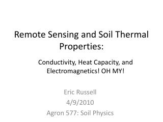
Sensitivity: Lower Frequencies Provide Information on a Deeper Soil Layer and are Less Affected by the Vegetation • Sensitivity of brightness temperature to changes in soil moisture • An optimal system maximizes sensitivity for both bare and vegetated surfaces • L-band: 1.4 GHz or 21 cm 2009-2013 2002 1970s High SMOS Aquarius SMAP Aqua Meteorological Satellites Bare Sensitivity Vegetated Low 1 2 3 5 10 20 30 50 Frequency (GHz)
Spatial Resolution: Overcoming Passive Microwave Limitations • Lower frequency means deeper soil sensing and less vegetation interference. • It also means coarser spatial resolution using conventional antenna technology. • Spatial resolution restricts potential applications. • The challenge is to achieve better sensing with higher spatial resolution. • SMOS will explore a potential technology but will provide only a 40 km resolution. • SMAP will explore a potential technology and different instrument design and will provide a 10 km resolution.
Evolution of L-Band Remote Sensing (Land) Day SMOS SMAPRadar-Radiometer ClimateApplications Aquarius Weather Applications Week Resolved Temporal Scales Evolution of L-Band Sensing CarbonCycle Applications Radiometer Radar Month ALOSSAR 100 km 10 km 1 km Resolved Spatial Scales *Material from SMAP Science Team
Spatial Resolution: Overcoming Passive Microwave Limitations • Lower frequency means deeper soil sensing and less vegetation interference. • It also means coarser spatial resolution using conventional antenna technology. • Spatial resolution restricts potential applications. • The challenge is to achieve better sensing with higher spatial resolution. • SMOS will explore a potential technology but will provide only a 40 km resolution. • SMAP will explore a potential technology and different instrument design and will provide a 10 km resolution.
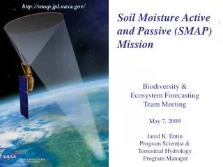
Soil Moisture Active Passive Mission (SMAP) • NASA • One of the first missions resulting from the NRC Decadal Survey • Soil moisture and freeze-thaw • Three day global coverage • Launch 2013
L-band radar and radiometer system with 6-m reflector Solution to spatial resolution is two-fold; a technology that uses a large antenna (deployable mesh) and enhanced resolution by combining high accuracy radiometry retrieval with high resolution radar. Soil moisture products; Radar resolution: 3 km Radiometer resolution: 40 km Combined product: 10 km SMAP Mission Concept
SMAP Status • SMAP Project and Program (March 2008) • Key Project Personnel • Program Executive: E. Ianson (NASA/Hq) • Program Scientist: J. Entin (NASA/Hq) • Project Manager: K. Kellogg (JPL) • Project Scientist: E. Njoku (JPL) • Deputy Project Scientist: P. O'Neill (GSFC) • Science Definition Team (SDT) (Selected Oct. 2008) • D. Entekhabi, MIT, Team Leader • W. Crow, U.S. Department of Agriculture • T. Jackson, U.S. Department of Agriculture (Validation WG) • J. Johnson, Ohio State University (RFI WG) • J. Kimball, University of Montana • R. Koster, NASA Goddard Space Flight Center • K. McDonald, Jet Propulsion Laboratory • M. Moghaddam, University of Michigan (Algorithm WG) • S. Moran, U.S. Department of Agriculture (Applications WG) • R. Reichle, NASA Goddard Space Flight Center • J. Shi, University of California, Santa Barbara • L. Tsang, University of Washington • J. van Zyl, Jet Propulsion Laboratory • SRR/MDR/PNAR Review (February 2009) • Algorithm and C/V Workshop (June 2009) • Applications Workshop (September 2009)
SMAP Validation • Based on SMAP mission requirements and mission product ATBDs • Objectives: • Demonstrate that the science requirements have been met post-launch and over the mission life • Improve soil moisture and freeze-thaw algorithms and products • Demonstrate the impact or value of mission products on specific applications
SMAP Science Data Products } Surface 0-5 cm Profile ATBDs under development.
Demonstrate that the science requirements have been met post-launch and over the mission life • Approach • Provide verifiedestimates of soil moisture over an area and depth equivalent to that measured by the SMAP radiometer and radar instruments or derived products throughout the project life • Provide a robust set of cover conditions and geographic/climate domains for validation • Provide continuous, consistent, and long term records with minimal latency • Elements: • Ground based soil moisture observations that represent footprint/grid soil moisture either by replication or scaling, which has been verified • Field experiments • Satellite product comparisons • Model product comparisons
In Situ Soil Moisture • Core element of validation-challenging problems • A single point within a satellite footprint is not going to provide a reliable estimate of the spatial average. • Robust validation requires international cooperation • AMSR-E experiences
Coverage gaps: some are real, others are the due to communication or cooperation There are issues that need to be addressed if these are to be of value to validation. Continuity Calibration Replication Scaling Coverage gaps Infrastructure Global In Situ Soil Moisture Validation Resources • There are a substantial number of in situ resources available for validation. Only a few provide the right kind of data (depth, frequency, latency, access) • Some regions (OK and NSW) have exceptional resources. USA Oklahoma Networks Little Washita Australia New South Wales Networks Kyeemba
In Situ Soil Moisture • Core element of validation-challenging problems • A single point within a satellite footprint is not going to provide a reliable estimate of the spatial average. • Robust validation requires international cooperation • AMSR-E experiences
Lessons Learned Validation of AMSR-E Soil Moisture Products Using Watershed Networks Standards Infrastructure Diverse Conditions Replication Installation Calibration SMEX+ Scaling Archive Algorithm Validation
Reynolds Creek, ID Walnut Gulch, AZ Little River, GA Little Washita, OK AMSR-E U.S. Soil Moisture Validation Sites
Lessons Learned Validation of AMSR-E Soil Moisture Products Using Watershed Networks Standards Infrastructure Diverse Conditions Replication Installation Calibration SMEX+ Scaling Archive Algorithm Validation
Algorithm Comparison • Three algorithms • 5 years of data
SMAP Soil Moisture Validation: In Situ Resources • Ground based networks are a core component: provide actual quantitative soil moisture observations to evaluate algorithm performance • Continue/establish a number of dedicated soil moisture validation sites • Develop techniques for scaling sparse networks to footprints • International cooperation • Access and archiving • Similar issues with freeze-thaw (temperature) and profile SM