Download
1 / 27
270 likes | 352 Views
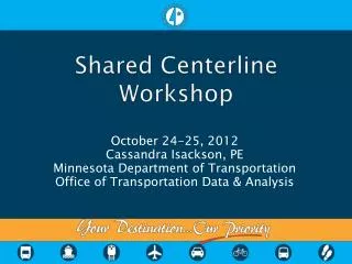
Centerline Update Project. Reporting Local Centerline Mileage Atlanta Regional Commission Regional GIS User Group September 7, 2011. Georgia Department of Transportation Office of Transportation Data. Statewide Centerline Update Project Local Centerline Mileage.

E N D
Centerline Update Project Reporting Local Centerline Mileage Atlanta Regional Commission Regional GIS User Group September 7, 2011 Georgia Department of Transportation Office of Transportation Data
Statewide Centerline Update Project Local Centerline Mileage • In January 2011 GDOT Commissioner Vance Smith sent a letter to every one of Georgia’s • 159 Counties • 531 Cities
Statewide Centerline Update Project Local Centerline Mileage • GDOT asked for… • The total number of miles of Local Public Roads owned by each local government; as measured by Centerline Miles
Statewide Centerline Update Project Local Centerline Mileage • Georgia Code 32-4-41(4) and 32-4-91(b) • says that all Local Governments must • Inform GDOT when they: • Acquire/Accept a road • or • Abandon a road
Statewide Centerline Update Project Local Centerline Mileage 153 Counties (96%) and 328 Municipalities (61%) have reported
Statewide Centerline Update Project Local Centerline Mileage • GDOT is required by state law to keep this information for calculating funding levels of… • Transportation Investment • Act of 2010 (TIA) • Local Maintenance Improvement • Grants (LMIG)
Statewide Centerline Update Project Local Centerline Mileage • Other uses include… • Creating County maps • Certified Mileage for Federal Reporting
Centerline Update Project Updating Centerline Mileage Data
Statewide Centerline Update Project Project Scope • Implement New Centerline Data Model • Bring Data Completely Up-to-Date By Adding, Modifying & Removing Roads • Cleanse Data - Resolve Various Issues • Ensure Clean Topology • Validate Local Mileage Totals • Provide Data Back To Local Agencies
Statewide Centerline Update Project Source Data • GDOT’s most current road centerline, bridge and railroad crossing data • Local GIS street and city/county boundary data • 2010 Census TIGER street/boundary data • Orthophotography (various sources)
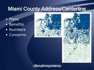
Statewide Centerline Update Project Data Issues • Roads that Extend Beyond/Stop Short of County Boundary
Statewide Centerline Update Project Data Issues • Out-of-Date The World of Coca-Cola The Georgia Aquarium -- Opened 2005
Statewide Centerline Update Project Data Issues • After Updates The World of Coca-Cola The Georgia Aquarium -- Opened 2005
Statewide Centerline Update Project Data Issues • Bad Centerline Geometry
Statewide Centerline Update Project Data Issues • Inaccurate Geometry BEFORE
Statewide Centerline Update Project Data Issues • After Updates AFTER
Statewide Centerline Update Project Data Issues • “Unknown Roads” (Route Type = U)
Statewide Centerline Update Project Data Issues • Topological Errors • (Overlapping & Intersecting Road Segments, Dangles, Pseudo-nodes)
Statewide Centerline Update Project Data Issues • Erroneous/Incomplete Ownership Assignment • (County Roads, City Streets, Private Roads, Etc.) • Roads Traversing City/County Boundaries • Various RC Coding Errors
Statewide Centerline Update Project Fulton County Data Update Fulton County Mileage – GDOT Data 20092010 GISDifference State Routes 415 377 -31 County Roads 1,249 592 -622 City Streets 1,796 3,213 +1,412
Statewide Centerline Update Project Data Update 2009 Reported 1,643 66 97 251 180 348 316 2010 GIS 1,507 65 99 227 189 354 305 Difference - 136 -1 +2 -24 +9 +6 -11 Mileage in some Fulton Cities Atlanta College Park Fairburn Johns Creek Milton Roswell SandySprings
Statewide Centerline Update Project Current Project Status • 5 Counties Complete • 38 Counties In Progress
Statewide Centerline Update Project Primary Project Goals • Establish & Maintain Complete and Accurate Statewide Road Centerline Data • Ensure Appropriate Mileages For All Local Agencies • Reduce the need for field data collection • Perform event-driven updates • Foster A Cooperative Environment • Build Working Relationships With Local Governments
Statewide Centerline Update Project How Can You Help? • Provide Digital (GIS) Street & Boundary Data; Imagery • Share Street Attribute Data • Assist With Identifying Road Ownership • (City, County, Private, Other) • Assist With Resolving Boundary Road Issues • Be Available To GDOT for Consultations Via Phone, E-Mail or Face-to-Face Meetings • Work With GDOT & Neighboring Agencies To Resolve Conflicts
Statewide Centerline Update Project Q&A Questions?
Statewide Centerline Update Project Contacts Michael D. Morris mimorris@dot.ga.gov 770-986-1366 Douglas Alexander dalexander@dot.ga.gov 770-986-1436