Download
1 / 24
240 likes | 336 Views
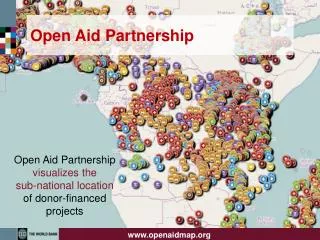
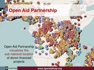
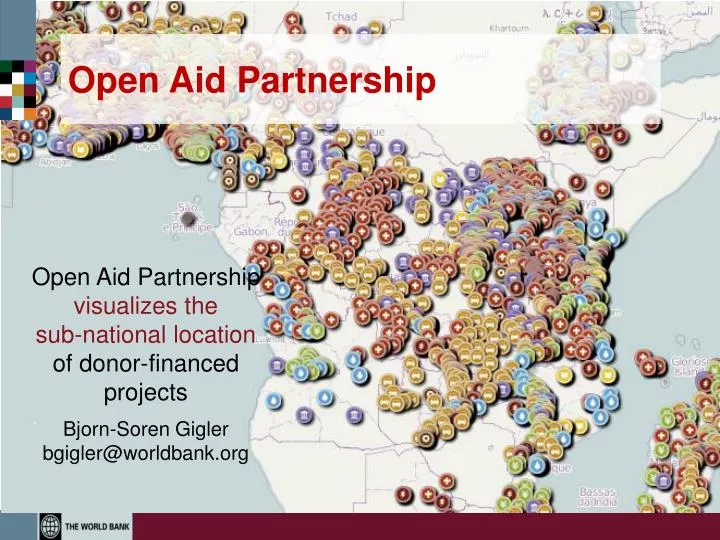
Open Aid Partnership . Open Aid Partnership visualizes the sub-national location of donor-financed projects Bjorn- Soren Gigler bgigler@worldbank.org. Achieving the MDGs- Geography Matters!. Subnationally , high concentration of poverty in the west.

E N D
Open Aid Partnership Open Aid Partnershipvisualizes the sub-national location of donor-financed projects Bjorn-SorenGigler bgigler@worldbank.org
Achieving the MDGs- Geography Matters! • Subnationally, high concentration of poverty in the west
Open Aid Partnership- Objectives Increase Aid Transparency and Citizen Engagement for Better Results Improve Aid Transparency: increase transparency through Open Data on aid flows and public service delivery Enhance Results: Better target, monitor, and coordinate aid flows within countries Establish Feedback Loop: Empower citizens and CSOs to provide direct feedback on project outcomes
All Bank-financed projects are mapped Maps for all 142 IBRD and IDA countries developed More than 30,000 project locations mapped combined with sub-national MDG indictors (poverty, infant mortality, malnutrition) Visualized geographic locations for 1,600 active Bank projects What we have done so far:Mapping for Results maps.worldbank.org
Mapping at Various Levels Regions Countries Projects Sectors maps.worldbank.org
Are health projects in areas with the highest infant mortality?
Project Level Bolivia: Decentralized Infrastructure for Rural Transformation Project • Benefits • Target activities to regions with most need • Promote synergies between components (Electrification and Telecomms) • Verify that services were provided • Monitor project results and impact • Transparency and social accountability
Local Open Data is Key Better targeting of schools based on needs
Institutionalize across the WB Group Switch to map view to show the project locations on a map of Africa.
Key Components of Partnership Open Aid Map a common platform to show locations of donor programs Country Platforms for open aid flows and public expenditures Citizen Feedback Loops to promote citizen engagement in the delivery of public services Capacity Development to empower CSOs and Citizens to effectively use and generate data Impact Evaluations to assess the impact of open aid on development outcomes
1) Open Aid Map Geo-coding of donor-financed projects based on IATI standard Joint Open Aid Map for better aid coordination (AidData) Visualize projects of 27 donors combined with poverty data
2) Country Mapping Platform Enable governments to collect, make openly available and visualize data on development assistance, budgets and public service delivery
Nepal Country Platform Pilot WB and USAID projects Poverty and WB projects Feedback Loop Public Expenditures
3) Citizen Feedback Loops • Build pilots to enable two-way information flows between citizens & governments • Citizen generated data, i.e. CheckMySchool.org
4) Capacity Development • Raise awareness among citizens about the power of open data • Strengthen Capacity of CSOs and Citizens to effectively use and generate open data • Engage, connect and empower communities to act upon provided data • Assist public service provider in receiving and responding to citizen feedback
5) Impact Evaluations • Provide an objective basis for assessing impact of Open Aid and Citizen Feedback Loops • Use Randomized Controlled Trial and Participatory Action Learning • Document and disseminate the lessons learned from evaluation findings
Suggested Priority Countries Africa: DRC, Kenya, Malawi, Mozambique, Nigeria, Rwanda, Tanzania, Uganda Latin America:Bolivia, Peru South Asia: Nepal, Sri Lanka East Asia: Indonesia