Download
1 / 11
140 likes | 891 Views
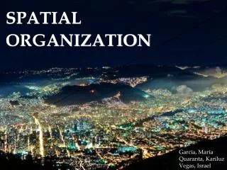
Valeria C. Ramos 09-10697 Andrés Stohlmann 09-. SPATIAL ORGANIZATION. DEFINITION. Spatial organization refers to the arrangement of physical and human objects on the Earth's surface. Location , distance, direction, density and arrangement.

E N D
Valeria C. Ramos 09-10697 Andrés Stohlmann 09- SPATIAL ORGANIZATION
DEFINITION Spatial organization refers to the arrangement of physical and human objects on the Earth's surface. Location, distance, direction, density and arrangement
ANALYSIS • The pattern of daily trips • The average built-up density • Density profile and density gradient FALTA BREVE RESUMEN DE CADA UNO…
CITY SHAPE • It is not possible to define an optimum city shape because city development objectives change with time. • Cities’ economic efficiency requires, therefore, avoiding any spatial fragmentation of labor markets
THE URBAN PLANNER’S WORK Urban planners should attempt to organize and structure cities spatial organization, for them to be fully functional. Land use regulations Urban planners disposes of three tools to influence city shape Infrastructures Investment Taxation
Transit use and motorization Linkages between spatial structure and city performance in various sectors Air pollution (due to transport) Poverty
CHARTS In less developed countries, there’s a tendency of growth of the cities, that happening because of the centralization and poverty.
Transportation and linkages are important when defining a city spatial organization. These models represent a monocentric city model (with stronger links) and polycentric models (with weaker links, although with more links).
Density profiles are based on density maps, themselves based on census data. Census data provides information about the spatial distribution of people when they are at home. This profiles provide the knowledge of population density in different city’s areas and allows the planner to solve problems according to those profile, problems like transportation (time and efficiency).
GLOBAL TRENDS • Because of the path dependency of the development of urban structure, dominantly monocentric cities tend to become less monocentric. And because income and mobility has been increasing in most large cities of the world, densities in central areas tend to get lower over time. However, it does not mean that every city is now tending toward a low density extremely polycentric model.