Download
1 / 31
380 likes | 647 Views
Coordinate Reference Systems. Jim Graham & Alex Daniels Colorado State University Warner College of Natural Resources. Coordinate Reference System. References coordinates to the earth Also known as CRS Always has 4 components: Coordinate System Units Projection Datum.

E N D
Coordinate Reference Systems Jim Graham & Alex Daniels Colorado State University Warner College of Natural Resources
Coordinate Reference System • References coordinates to the earth • Also known as CRS • Always has 4 components: • Coordinate System • Units • Projection • Datum
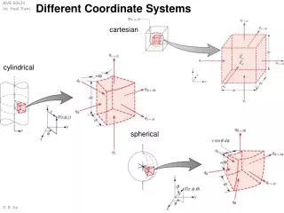
Coordinate Reference Systems • Coordinate System • Cartesian or Rectangular • Spherical • Units • Projection • Geographic or Un-projected • UTM • State Plane • Datum
Spherical Coordinates • Longitude: Degrees East or West from the prime meridian • Latitude: Degrees North or South from the Equator
Geographic “Projection” -180° 0° 180° 90° 0° -90°
Units • Spherical: • Degrees • Rectangular: • Metric: Meters, Kilometers • English: Miles, Feet • Nautical: Nautical Miles • Elevation: • Metric: Meters • English: Feet
Projected Coordinate Systems • Use projection to display 3 dimensional locations on to a surface in 2D • Uses Cartesian coordinates (rectangular)
Cogito Ergo Sum Cartesian Coordinates(Rectangular) • X,Y • Easting, Northing • Units: Miles, Meters, Feet, Nautical Miles Y North X East
Projections • Different orientations, different projections http://welcome.warnercnr.colostate.edu/class_info/nr502/lg1/lg1_master.html
Projections • There are hundreds of projections • 98% of the time you will be using: • Geographic (Un-Projected) • Universal Trans-Mercator (UTM) • State Plane
Datums • There are hundreds of Datums • If you only work in the US, 98% of the time you will be using: • NAD 27 • NAD 83 • WGS 84 • HARN • Recommendation: “Project” everything to WGS 84
Summary • Coordinate Reference Systems (CRS) reference coordinates to the earth • They are composed of: • A spherical or Cartesian Coordinate System • Units • Projection • Datum
CRS in GIS • Your data must have a CRS! • We can guess at units, coordinate system, and even the projection • Must find the datum! • Sources: • “prj” file • Internal to file • From metadata • Over the phone, email, whatever!
Shapefile with defined CRS • Units: Degree • Projection: • Geographic • GCS=Geographic coordinate system • Datum: • NAD 83
Shapefile without a CRS • Click on “Select” • Or…
Defining the CRS in ArcGIS • ArcToolBox: • Data Management Tools • Projections and Transforms • Feature • Project • Raster • Project • Define Projection (they mean CRS)
Changing the CRS ArcToolBox: Data Management Tools Projections and Transforms Feature Project Raster Project Define Projection (they mean CRS)