Download
1 / 14
140 likes | 312 Views
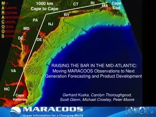
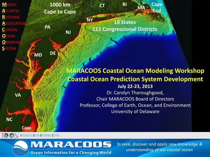
M iddle A tlantic R egional A ssociation C oastal O cean O bserving S ystem. 1000 km Cape to Cape. RI. Cape Cod. CT. MA. NY. 10 States 111 Congressional Districts. PA. NJ. DE. MD. MARACOOS Coastal Ocean Modeling Workshop Coastal Ocean Prediction System Development

E N D
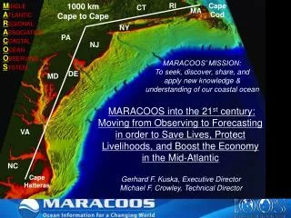
Middle Atlantic Regional Association Coastal Ocean Observing System 1000 km Cape to Cape RI Cape Cod CT MA NY 10 States 111 Congressional Districts PA NJ DE MD MARACOOS Coastal Ocean Modeling Workshop Coastal Ocean Prediction System Development July 22-23, 2013 Dr. Carolyn Thoroughgood, Chair MARACOOS Board of Directors Professor, College of Earth, Ocean, and Environment University of Delaware VA NC Cape Hatteras To seek, discover and apply new knowledge & understanding of our coastal ocean To seek, discover and apply new knowledge & understanding of our coastal ocean
Background Ocean Studies Report Called for: Improved partnerships between ocean scientists, federal agencies, and the oceanographic institutions as the key to understanding the oceans and their effects on our lives. To seek, discover and apply new knowledge & understanding of our coastal ocean To seek, discover and apply new knowledge & understanding of our coastal ocean
Today Plan To seek, discover and apply new knowledge & understanding of our coastal ocean To seek, discover and apply new knowledge & understanding of our coastal ocean
Workshop Context Context In the present funding environment, it is IMPOSSIBLE for an organization to evolve and function alone. A key way of moving forward is with collaborative and practical PARTNERSHIPS.
Workshop Context • Functioning Partnerships Require: • Common vision, purpose, and commitment to excellence. • Shared investment in sustaining effective partnership: • Understanding of respective roles, responsibilities, and mutual benefits. • Understanding of major coupling issues (scales, software architectures, etc.) • Formalized mechanisms to leverage each other’s strengths and activities (w/o turf concerns). • Agreement on stakeholders and customers. • 4. Diversified funding base.
Stakeholder Engagement • Stakeholder Liaison Service serves as a vital link between ocean data generators, data product developers, and end users. Ecosystem Decision Support Ocean Observation MarineSafety Offshore Wind Energy Water Quality Coastal Inundation From Observation to Prediction and End Use
Stakeholder Needs COASTAL INUNDATION/STORMS (NCEP, State officials, Emergency Mgrs, Navy) Ocean models for hurricane forecast ensemble (White Board exercise) Inundation/sea level rise preparedness post-Sandy Storm Surge Warning System to street level WATER QUALITY (State officials, FDA, NCCOS) Water Quality monitoring and forecasting product ECOLOGICAL DECISION SUPPORT (Commercial and Rec fishermen, NMFS) Bottom temperature maps at various resolutions and frequencies MARITIME SAFETY (Pilots, Boating community) Hurricane early warning forecasting and preparedness Smart Phone App for tide and current models OFFSHORE WIND ENERGY (BOEM, NMFS) Pelagic water column assessments in WEA lease areas
Workshop Goal Goal To foster broad-based partnership and collaboration in developing and executing the implementation plan for the MARACOOS Modeling, Prediction, and Analysis Subsystem
Workshop Objectives Communicate existing operational modeling and analysis capabilities and needs. 2. Develop a workable approach to connection between operational and R & D modeling and analysis activities that link federal operational facilities with MARACOOS modelers. Outline “next step” coastal ocean (also linking to global/basin, estuarine, and tidal riverine scales) modeling projects based on stakeholder needs. Develop budgets associated with each “next step” project.
Workshop Task Important Questions to Answer Who are the stakeholders/customers for our models? Who receives priority attention? What are the most immediate problems, that if solved, would improve/enhance our model accuracy and end use? Are there additional data required to improved our models? What are the common metrics that allow modeling across the region and among partners? How do we advance ensemble modeling that includes ocean data? What are the intersections of previous and ongoing work? What are the major gaps in our capabilities? How do we optimally leverage each other’s activities? What formal infrastructures need to be put into place to ensure collaboration. What processes/mechanisms does MARACOOS put into place facilitate moving from research to operations?
Modeling Implementation Funding What is the level of support required for MARACOOS to undertake a productive modeling effort? Where do we obtain these dollars?
Working Together Members GOV: 23% NGO: 14% B/I: 35% ACAD: 23%