Download
1 / 15
150 likes | 255 Views
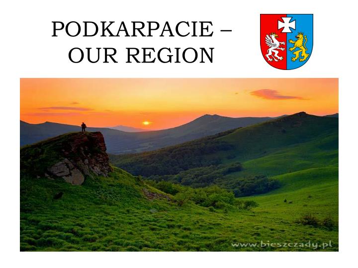
PODKARPACIE – OUR REGION. Podkarpackie province is the Polish administrative division, one of the 16 th provinceses created in 1999. Emerged by union of old lands of Rzeszów , consists of Przemy ś l, Rzeszów, Krosno and part of the Tarnobrzeg and Tarnów provinces (before1975).

E N D
Podkarpackie province is the Polish administrative division, one of the 16th provinceses created in 1999. Emergedby union ofold lands of Rzeszów, consists of Przemyśl, Rzeszów, Krosno and part of the Tarnobrzeg and Tarnów provinces (before1975). • The region is located in south-east part of Poland, it borders with Ukraine from the East, with Slovakia from the south and with other Polish provinces: fromnorth-east with Lubelskie, from north-westwith Świętokrzyskie and from west with Małopolskie.Rzeszów is the capital and the most important city of Podkapackie province.
The region is characterized by low unemployment ratio and relatively dynamic economic growth. The agriculture is the most important branch of economy. However, Podkarpacie rural farms are very crumbled, that negatively effects the level of life of those whose sole is the only source of the family support. • Beautiful landscapes encourage to participatein tourism, to visit historical cities with numerous antiques and recreation centres (ski slopes, tourist routes). In the region, particularly in the south, touristic infrastructure spreads very rapidly. More and more hotels, boarding houses and holiday centers are built. Due to creation of international airport in Rzeszów in 2005, more and more foreign tourists and visitors come to Podkarpacie. • Aircraft industry is particularly characteristic for Rzeszów. This sector slowly grows and gains a stronger position. Besides, pharmaceutical industry, information and nutritive sectors of industry have a strong position on the marked. In Mielec, in the frame of Special Economic Zone, many new companies have been established that totally gives the place to work for over 20 thousand people. • Citizens of Podkarpacie province enjoy the highest average length of life. Education is also on the high level with a few colleges with very good reputation. Graduates are well qualified and are wanted employees for Polish and foreign employers.
Rzeszów – Capital of Podkarpacie Lubomirski Castle Rzeszów Downtown 3rd of May Street
History • In 1937-1939 creation and modernization of arms plant started within the Central Industrial District. Rzeszów became an important center of aircraft industry and arms. The dynamic growth of Rzeszów was interrupted by the II World War, during this time the city was partially destroyed. In 1941 Nazisbuilt a ghetto, which functioned till November 1943. Jews were placed in the ghetto (before the war 14 thousand of Jewish people had livedin Rzeszówthat was about 30 % of all population).Laterthe Jews were placed in an extinction camp in Belzec. • The city has been established and received the city rights from the King Kazimierz the Great on January19th 1354. In XVI century the city already owned organized administration. In 1591 the City Hallwas built and in 1600the castle was built. The city was fortified in 1627. In 1638 it became the property of Lubomirski dynasty. In 1772 the city got underAustrian annexation. Forthe next 146 years it was the part of Habsburg’s imperium. After Poland recovered her independence the meaning ofRzeszów still grew.
Przemyśl • Oldest city of our region and one of oldest cities in Poland. In earlyMiddle Ages one of historic castles of family Czerwieński, object of continuous contest of Poland, Russ and Hungary. Than among others, part of Russ Halicka, as well as the capital of independent princedom. From 1344 capital of extensive Land of Przemyśl. • Multicultural city, where representatives of many nations live beside (Poles, Ukrainians, Gypsies) and religion, predominating catholic, also grekokatolic, orthodox and representatives of protestants streams: methodists, adwentists, baptists, as well as witness of Jehovah. • After the I annexation of Poland, Przemyśl was under the Austrian, during the period of Galician autonomy one of most important cities of Galicia, transformed into the third largest fortress in Europe (Przemyśl Fortress) with enormous military garrison.
Łańcut • City founded by the king Kazimierz the Great. Location of the city on the Magdeburg’s law in 1376 of enforcement of prince Władysław Opolczyk in the valleyof Wisłok river. Kingfetched German colonialists inŁańcut. • In XV century the wooden castle was built which in the XVI century rebuffed Tatar invasion.
Krasiczyn • Krasiczyn Castle is one of the finest treasures ofrenaissance architecture in Poland, it also belongs to the finest castles in Europe. It was built on the turn of the XVI and XVII centuries by Stanisław Krasicki and his son Marcin . • Four round towers are placed in the castle’s corners, their names symbolize approved by founders hierarchy of world, including presence and enternity. From the castle’s courtyard, it is possible to admire seldom representative graphit decorationsshowing the biblical sceens, with busts of emperors medallions, pictures of Polish kings and hunting sceens.
Baranów Sandomierki • An evolution and development of Baranów decided the advantageous of communication through theriverWisła. First mentions about the city dates from 1135 the times of Boleslaw Krzywousty. The name of the city has its explanation from the cultivating of ram farming that from immemorial times inhabitants run. Headquarters of Leszczyński dynasty wasdesigned according to the project of Santi Gucci in 1591-1606. • At the beginning there was only a small castle. In the Middle Ages the defensive city was built. The late renaissancecastle is located in Baranów.Because of its similaritiesto Wawel Castle in Kraków it is called small Wawel. • First mentions date from 1135 but it received city rights in 1354 from hands of kings Kazimierz the Great. The city spread out due to commerce cereal. At the end of XVI century craft developed and spread outin Baranów. During the II World War Germans have dislodged all Jews from Baranów.
National Park of Bieszczady • National Park of Bieszczady was created in 1973. Its one of the 23 national parks in Poland. National Park of Bieszczady is the third largest national park in Poland. It includes massif of Tarnica, Krzemień and Halicz and is situated near the top parts of Połonina Caryńska about surface 59,55 km2.
Fauna and flora ofNational Park of Bieszczady • From among 230 sorts ofvertebrates, in park it is possible to meet such animals as: Puchacz Eskulapa Snake Bison Eagle
Fauna and flora ofNational Park of Bieszczady • Vegetation presents ok. 780 sorts of vascular plants, 250 sorts mosses, 500 sorts of overgrowth and 1000 sorts of mushrooms.
Bieszczady • Bieszczady were mentioned for the first time in 1259 in the Hungarian document concerning boundary course back mountain over Jaśliska. It is a tourist and recreation center in South-East part of Poland.
This land was originally named: Byesczad. It was located in Russia, Polish and Hungarian boundary zone. Bieszczady was a very arguable field until 1340 when Kazimierz theGraet attatched those lands to Poland. • After beginning of II World War in force of pact Ribbentrop-Mołotow, Germany and Russia divided the land between themselves. After the war in 1951 Poland was enforced to mutual exchange of territory based on the agreement with Soviet Union, according to this agreement Poland had to give up the territory on the west of Bug river and get the similar size territory with Ustrzyki and Lutowiska. Those fields were attractive for Russians because of the presence of petroleum and carbon. Lands which (have fallen to Poland were weak, undeveloped with exhausted fields of petroleum, however after many years, the dam and water power station were built and Bieszczady become attractive tourist centre. • Main business of habitants leaving on this land were: animal breeding and burning coal out of wood carbon.
Artificial Lake Solina was created in 1968 through piling water of San and Solinka rivers. • The water power station produces 200 MW of electricity. • It has surface about 22 square km; capacity of 472 million cubic metres - biggest in Poland). • Maximum depth is 60 m by the dam.