Download
1 / 7
70 likes | 196 Views
Update on MISR applications to Shrub Abundance Mapping in Desert Grasslands. Mark Chopping, Lihong Su, Albert Rango, Debra P.C. Peters, John V. Martonchik, and Andrea Laliberte 3 March 2006. Structure: A Strength of Multiangle Remote Sensing .

E N D
Update on MISR applications to Shrub Abundance Mapping in Desert Grasslands Mark Chopping, Lihong Su, Albert Rango, Debra P.C. Peters, John V. Martonchik, and Andrea Laliberte 3 March 2006
Structure: A Strength of Multiangle Remote Sensing • Multi-angle sampling provides sensitivity to vegetation canopy structure, even for low density canopies such as those encountered in the desert grasslands of the southwest US • Canopy structure can be inferred through various approaches, including geometric-optical modeling • A major prerequisite for GO modeling is the ability to estimate the relative contributions of the upper canopy (i.e., shrubs) and the soil-understory component (exposed soil, grasses, sub-shrubs, and forbs)
0.20 Optimal: y = 0.9985x + 0.0003 R = 1.0000 2 0.15 sunlit crown shadowed crown Modeled Fractional Shrub Cover 0.10 Estimated: y = 0.7252x + 0.0306 R = 0.7352 2 0.05 0.05 0.10 0.15 0.20 Measured Fractional Shrub Cover sunlit ground shadowed ground Geometric-Optical Modeling of Vegetation • GOAL: to obtain areally-weighted proportions of background (soil, understory) and upper canopy components. Geometric-Optical (GO) models provide one method of understanding the sensitivities of passive multi-angle sensing to canopy structure parameters of practical significance to ecosystem modeling: • woody shrub cover • mean shrub crown shape and radius • shrub number density • canopy height • soil/understory brightness and anisotropy • The impact of using estimated (∆) • over optimal () background BRDFs for 19 cases covering a wide range of shrub cover/size and understory configurations. The background contribution is the most important source of error in modeling canopy-level reflectance at the landscape scale
shrub cover = 0.12 (dense understory) shrub cover = 0.07 (sparse understory) Red Bidirectional Reflectance Factor shrub cover = 0.19 (sparse understory) shrub cover = 0.10 (sparse understory) View Zenith Angle (˚) View Zenith Angle (˚) (a) (b) (c) (d) Simulations of MISR BRFs in the red band and at nine viewing angles A good match is obtained between modeled and observed BRFs from MISR 275 m red band data. GO model: Simple Geometric Model (SGM), using the Walthall model to represent the soil-understory contribution. Shrub crown radii and number density were measured using IKONOS 1 m panchromatic imagery. MISR observations Modeled (simple geometric model) …… optimal background ---*--- estimated background - - - without shrubs (G.kG)
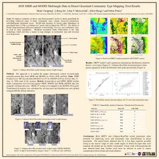
Mean (0.026) N = 441 250 m Retrieval of woody shrub cover at landscape scales • Shrub cover was measured using IKONOS panchromatic imagery for a 5 km2 area in a Chihuahuan Desert grassland with varying degrees of shrub encroachment. • 80% of retrieved shrub cover values using MISR data were within 0.05 of the measured value • This is the first time that fractional woody shrub cover has been mapped using medium resolution Earth Observation data
Retrieval of woody shrub cover at landscape scales • Measured • Retrieved • 250 m2 raster cells 0.04 0.28 0.07 0.21 • There is broad agreement in the spatial distributions of the retrieved and reference data for fractional woody shrub cover in this Chihuahuan Desert grassland. 80% of retrieved shrub cover values retrieved using MISR data were within 0.05 of the measured value. To our knowledge, this is the first time that woody shrub cover has been mapped over sparse and dense backgrounds using medium resolution Earth Observation. Although there is some divergence between retrieved and measured distributions, there is also error in the reference data; these were obtained via thresholding IKONOS 1 m panchromatic imagery.
M.Well, etc indicate Net primary produvity sampling sites: M=mesquite T=tobosa P=playa C=cresosotebush G=grama grass. Boundaries of vegetation mapping units. grasses: mesquite creosotebush upland yucca elata tarbush other shrubs snakeweed playa Woody shrub cover at landscape scales from MISR Fractional Woody Shrub Cover • LTER Vegetation Map (1998) 0.46 0.00 N.B. no corrections were applied for topographic effects on acquisition angles (affecting the E. part of the scene)