Download
1 / 22
220 likes | 227 Views
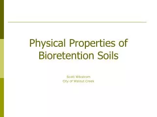
Geotechnical Properties of Glacigenic Soils and Slope Stability. David A. Franzi Center for Earth and Environmental Science SUNY Plattsburgh. General Laboratory Format. Skills and content exercises are organized around a central research question. Introduction

E N D
Geotechnical Properties of Glacigenic Soils and Slope Stability David A. Franzi Center for Earth and Environmental Science SUNY Plattsburgh
General Laboratory Format Skills and content exercises are organized around a central research question. • Introduction • Provide background information and references • Formulate hypotheses and experimental design • Articulate workload and final product expectations • Content and Skills Exercises (data collection & analysis) • Individual or small group assignments • Compilation of cohort database • Interim reports are due upon completion of each exercise • Capstone Exercise (synthesis) • Students are encouraged to discuss interpretations but writing is an individual effort • Emphasize connections between effective writing
Laboratory Exercises for Geotechnical Properties of Soils and Mass Wasting • Skills & Content Exercises • Morphometry (topographic mapping & cross sections) • Sediment Composition (mineral, chemical, and etc.) • Gravimetric Analyses • Particle Size Analyses • Atterberg Limits • Soil Classification • Hammer-Seismic Profiling • Shear Tests • Capstone Exercises • Soils as Engineering Materials • Glacial Sedimentology and Stratigraphy • Sediment Provenance • Slope Stability Analysis
Landslide SusceptibilityProject Structure • Topographic and Geologic Survey (Weeks 1-2)* • Measure stratigraphic section • Collect and prepare samples for gravimetric and particle-size analyses • Produce a topographic map and geological cross-section • Gravimetric Analysis (Week 2) • Lab analysis runs concurrently with topographic and geological survey exercise, data are reported with the particle-size analysis • Determine volumetric water content, porosity and density of soil samples • Particle-size Analyses (Weeks 3 and 4) • Sieve and hydrometer (or Coulter Counter) methods • Compile hourly and daily databases • Atterberg Limits (Week 5) • Determine liquid and plastic limits on clay soils • Soil Classification (Week 6) • Classify soil types using the Unified Soil Classification • Slope Stability Assessment (Week 7) Content and Skills – Synthesis *Interim reports are submitted at the end of each exercise. These are edited and included as appendices in the final report
Laboratory Exercises for Geotechnical Properties of Soils and Mass Wasting • Materials and Supplies • SoilTest Ely Volumeter • Soil Test Torvane and pocket penetrometer • Liquid-Limit cups • Aluminum moisture cans • Drying oven • Balance (± 0.001 g) • Standard surveying equipment • Shear strength sampling materials and testing apparatus
100 0 100 200 2 0 2 4 6 8 10 NY North kilometers meters Example: Landslide Susceptibility at the Plattsburgh Air Force Base Marina Lake Champlain PAFB marina landslide River PAFB marina landslide Saranac
Contour interval = 1 meter North 0 5 10 meters What factors control slope processes at the PAFB Marina?
Plattsburgh Air Force Base Marina Section West East 42 40 laminated to thinly bedded marine sand and silt Champlain Sea water table 38 springs 36 fossiliferous marine clay Elevation (meters) Approximate extent of colluvium in 1996 34 lacustrine varved clay Massive to ripple cross-laminated medium to fine sand Lake Vermont 32 Lake Iroquois breakout deposit colluvium 30 diamicton Lake Champlain 28 limestone 0 5 10 Vertical Exaggeration = 2X Horizontal Scale (meters)
Gravimetric and Volumetric Data for Glacial Lacustrine and Marine Deposits at the Plattsburgh Air Force Base Marina Elevation at top of section = 42 meters a.s.l.
Porosity (h), Vol. Moist. Cont. (q) 42 Particle Size Soil Density h q rsat rf Mean (1s error bar) rb generally unfossiliferous, laminated to thinly bedded, marine fine sand and silt 40 thinly laminated to thinly bedded, unfossiliferous, marine fine sand and silt 38 water table Elevation (meters a.s.l.) 36 fossiliferous, thinly laminated marine clay thinly laminated varved lacustrine clay 34 32 medium sand 0 8 0 20 40 60 1.0 1.4 1.8 2.2 calcareous till (f) (%) (g/cm3) Plattsburgh Air Force Base Marina Section 16
42 Mean (1s error bar) generally unfossiliferous, laminated to thinly bedded, marine fine sand and silt 40 thinly laminated to thinly bedded, unfossiliferous, marine fine sand and silt 38 water table Elevation (meters a.s.l.) 36 fossiliferous, thinly laminated marine clay wPL wLL wn thinly laminated varved lacustrine clay 34 32 medium sand 0 3 6 0 8 16 0 20 40 60 calcareous till Plattsburgh Air Force Base Marina Section Torvane Shear Strength Atterberg Limits Water Content (%) Particle Size (f) (%) (Kg/m2)
Loss on Ignition Microfauna 42 generally unfossiliferous, laminated to thinly bedded, marine fine sand and silt 40 thinly laminated to thinly bedded, unfossiliferous, marine fine sand and silt 38 water table Elevation (meters a.s.l.) 36 fossiliferous, thinly laminated marine clay thinly laminated varved lacustrine clay 34 32 medium sand 0 5 10 0 5 10 15 0 4 8 calcareous till (%) (specimens/gram) (3-pt avg., max = 10) Plattsburgh Air Force Base Marina Section Chittick Carbonate Total Total Calcite Candona Forams LOI550 LOI1000 12,990 cal. y.b.p. Dolomite (%)
42 40 38 36 Elevation (meters) 34 32 30 28 0 5 10 Horizontal Scale (meters) Railroad activity (ground vibrations?) and drainage diversions West East laminated to thinly bedded marine sand and silt water table Ground-water sapping at the base of the sand section fossiliferous marine clay Weak, saturated clays lacustrine varved clay Massive to ripple cross-laminated medium to fine sand Removal of lateral support by beach erosion Lake Iroquois breakout deposit Seasonal & long-term controls on Lake Champlain water level colluvium diamicton limestone Vertical Exaggeration = 2X
Data Analysis • Data Synthesis INSTRUCTOR JOINT STUDENT • Define learning objectives and skills • Set reasonable expectation levels • Pose the question • Provide background information and references • Articulate workload and final product expectations PRE- PROJECT • Familiarize yourself with the question – READ LITERATURE! • Formulate hypothesis(es) • Design experiments • Define project focus • Plan field work • Assign working groups and tasks • Anticipate Contingencies • Data Collection Iterative Process • Mentor and Advise END PROJECT • Communicate Results • Assessment
Summary • Advantages of Long-Term Projects • Provides time for students to reflect and contemplate their results–students receive feedback at interim steps; • Stimulates student interest and creativity; • Integrates skills and content from discrete exercises; • Links learning to real-world issues and problems; • Real data always produce unexpected teaching points that enhance the planned learning activity; • Engages students in all facets of a project (planning, execution and reporting); • Reinforces learning from other courses and experiences (e.g. knowledge of regional geology, effective writing mathematics, spreadsheets, and etc.); • Helps ease the transition from the mindset of student to professional geoscientist.
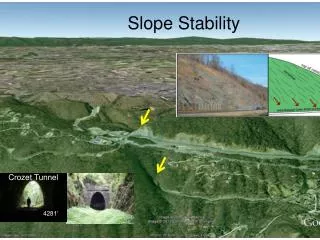
Exportability • Site Availability • May be a problem for some campuses but most activities can be derived from local consultant or municipal case studies. • Equipment Cost • Small-scale projects can be implemented for several hundred to a few thousand dollars • Time Constraints Macomb Mtn. Landslide, Adirondack Mountains, NY
Rethinking Class Time Applied Environmental Science Program SUNY Plattsburgh and The William H. Miner Agricultural Research Institute AESP Model: • Fall semester residential program featuring 5 inter-related, upper-division undergraduate environmental science and geology classes • Constructivist pedagogy; emphasis upon small-group, project-based learning • Day-long course format provides pedagogical flexibility that; • Creates an informal student-centered learning environment • Allows seamless integration of lecture instruction and field or laboratory projects • Facilitates inclusion of long-term projects • Increases effective geographic range for field excursions • Affords time for reflection and contemplation
Slump at Whallonsburg, NY July, 1987 Oblique Aerial Photograph Toe of Slide – Bob Fuller for Scale
Fissures in Overconsolidated Clays at Head Scarp Slump at Whallonsburg, NY July, 1987 Jack Ridge Sampling Clay at Head Scarp Toe of Secondary Slump