Download
1 / 20
200 likes | 288 Views
New and Many Eyes on the Sea Crowd Sourced Bathymetry IGNITE Oceans 12. This Discussion. Suspend and Accept. Change Comes Fast. If you grew up with this. ... then this is a great technology ...and if you grew up this. ... then this really hot (NOW). Really it is.

E N D
New and Many Eyes on the SeaCrowd Sourced BathymetryIGNITEOceans 12
This Discussion Suspend and Accept
Change Comes Fast If you grew up with this ... ... then this is a great technology ...and if you grew up this... ... then this really hot (NOW)
What is Crowdsourcing • Sourcing tasks traditionally performed by specific individuals to a group of people or community (crowd) producing solutions from amateurs or volunteers working in their spare time, or from experts or small businesses which were unknown to the initiating organization.
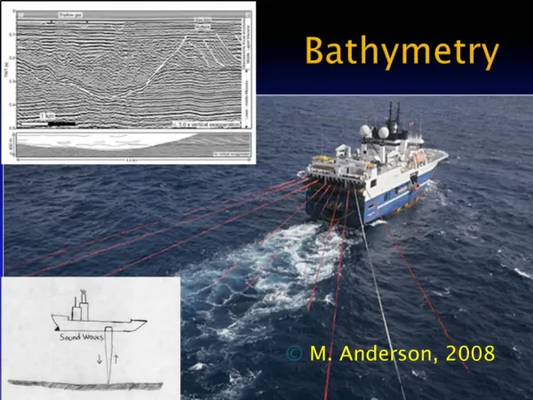
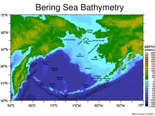
Crowd Sourcing Oceano and Bathy Data Crowd Source at work • Coastal waters are inadequately surveyed the amount of coastal waters that are adequately surveyed is below 50%. • The high cost of ship surveying - about $30,000 per square mile • Recreational Mariners • logging depth, • position, • SST, • dissolved O2, • acidification,
Why Crowd Sourced Bathymetry • U.S. coastal waters have never been completely surveyed, and for the areas that have been surveyed, approximately 50% of the sounding data is pre-1940, • It isexpected to take NOAA 166 years to survey the 500,000 square nautical miles (SNM) of navigationally significant waters (taken from NOAA HSRP Report 2007). Obvious need for supplemental charting using a cost-effective approach
New and Many EyesEvery Boater Can Contribute Responsibility Involvement Commitment
The New World Order Timeliness: not weeks or days - but within seconds Connectedness: always connected, Content: if it isn't online it doesn't exist Choice: multiple ways to get what you want Depth: links to ever increasing detail Knowledge: everybody shares Innovative: a connected search for better ways Unlimited Workforce: anyone can add Wikis: wiki-based information from fellow travelers Trust: technology works, large institutions don't Free: as in virtually costless
Its OK to Challenge the Current Charts and Products Current official charts have soundings from all these sources What’s wrong with GPS and electronic soundings?
Crowd Source BathymetryDelaware River 2004 265,000 gallons of oil into the Delaware River 115 miles of shoreline affected The Athos I collided with three uncharted and undetected submerged obstructions in the channel and anchorage. The Athos I incident alone has cost the ship owner and his insurer over $165 million. The true value of wildlife lost and port commerce delayed or deferred cannot be calculated.
Crowd Sourced Bathymetry How many vessels passed over these before the Athos I did? What one vessel passes over, without knowing, or caring for that matter, will potentially be of significance to any vessel with a deeper draft.
Weather Data True and apparent wind speed and direction Barometric pressure Relative humidity Air and wind chill temperatures Water Quality Water temperature pH Conductivity Dissolved oxygen Other possible metrics include:turbidity, oxidation-reduction potential (ORP) Pollution/oil spill applications Optional Weather &Environmental Monitoring Barnegat Bay Water Temperatures
Over 50% of soundings are from stationary vessels “Float” data not only provides depth measurements, but also contributes to tide corrections Float data snippets range from minutes to consecutive days, weeks Representative Tide Data Potential to extend and enhance NOAA’s current fixed-tide-station network
Hi-Res Storm Surge Datafor Modeling & Visualization • Application: Obtain highly localized (space, time), very-fine-scale storm surge and met data – before, during, and after tropical storms • Utility: Selectable-location data for cell-by-cell NOAA model validation Source: NOAA Storm Surge Roadmap (21 JUL 2010)
Yes We All Can Pressure for change Use Social Networking technology Support technologies that give tools to the crowd Encourage standards to keep specific layers open for direct user input Free up as much supporting data as possible Fast lane new information directly to mariners tagged with quality level ratings Incorporate photo realism and 3D models Encourage and respond to user ratings Begin to employ crowdsourcing, initially on non- regulated publications
Benefits New Data New Engagement
Benefits New Data New Engagement