Download
1 / 32
380 likes | 809 Views
Floodplain Mapping using HEC-RAS and ArcView GIS. http://www.ce.utexas.edu/stu/tateec. Eric Tate Francisco Olivera David Maidment. Outline. Motivation and Objectives HEC-RAS Hydraulic Model Stream Cross-Section Mapping GIS Data Models 3-D Terrain Modeling Floodplain Mapping.

E N D
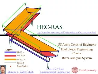
Floodplain Mapping using HEC-RAS and ArcView GIS http://www.ce.utexas.edu/stu/tateec Eric Tate Francisco Olivera David Maidment
Outline • Motivation and Objectives • HEC-RAS Hydraulic Model • Stream Cross-Section Mapping • GIS Data Models • 3-D Terrain Modeling • Floodplain Mapping
Map-Based Hydrology and Hydraulics ArcView Input Data DEM ArcView Flood plain maps CRWR-PrePro HEC-RAS Water surface profiles HEC-HMS Flood discharge
Motivation: Why map floodplains in GIS? • Computer automation results in time and resource savings versus manual floodplain plotting • Flood insurance rate determination • Economic impact analysis and flood early warning systems • Design of drainage control structures, including storm drains, culverts, and bridges
Objectives • Develop procedure to process computed water surface profiles generated from HEC-RAS hydraulic modeling anddraw floodplain maps in ArcView GIS • Synthesize a TIN terrain model from HEC-RAS cross-sectional data and a digital elevation model (DEM)
Outline • Motivation • HEC-RAS Hydraulic Model • Stream Cross-Section Mapping • GIS Data Models • 3-D Terrain Modeling • Floodplain Mapping
HEC-RAS: Background • Hydraulic model of the U.S. Army Corps of Engineers • Input = cross-section geometry and flow rates • Output = flood water elevations Cross-Section Schematic
HEC-RAS: Cross-Section Representation • Points describe channel and floodway geometry • Bank station locations • Water surface elevations and floodplain boundaries
HEC-RAS: Output Graphical Text File
HEC-RAS: Data Translation • Data translation from HEC-RAS output text file to dbase table • Table data includes the river station IDs, various cross-section coordinates, reach lengths, & computed flood elevations
Outline • Motivation • HEC-RAS Hydraulic Model • Stream Cross-Section Mapping • GIS Data Models • 3-D Terrain Modeling • Floodplain Mapping
Stream Centerline Mapping • Digital orthophotograph and road coverage used as a base map • User defines stream centerline • Definition points identify key stream cross-sections
Cross-Section Mapping One to one relationship established between table records and definition points
Cross-Section Mapping • Assume straight line cross-sections • Proportional aliasing for cross-section location • User input for cross-section orientation
Outline • Motivation • HEC-RAS Hydraulic Model • Stream Cross-Section Mapping • GIS Data Models • 3-D Terrain Modeling • Floodplain Mapping
GIS Data Models: Vector Points, lines, and polygons Typically used for linear feature representation
GIS Data Models: Raster Digital Elevation Model (DEM) Square grid cells Typically used for steady-state spatial modeling and two-dimensional surface representation
GIS Data Models: TIN Triangular Irregular Network (TIN) Mesh of equilateral triangles Used for three-dimensional surface representation and drainage analysis.
Outline • Motivation • HEC-RAS Hydraulic Model • Stream Cross-Section Mapping • GIS Data Models • 3-D Terrain Modeling • Floodplain Mapping
3D Terrain Modeling: Procedure Outside Channel: Raster Inside Channel: Vector Result: TIN
3D Terrain Modeling: Procedure DEM raster to vector conversion Form polygon bounding the cross-sections Delete any DEM points falling within the bounding polygon
3D Terrain Modeling Problem: elevation differences at the end of the cross-section
3D Terrain Modeling Re-sample cross sections to eliminate elevation differences
3D Terrain Modeling Build TIN model from re-sampled cross-sections and DEM
Outline • Motivation • HEC-RAS Hydraulic Model • Stream Cross-Section Mapping • GIS Data Models • 3-D Terrain Modeling • Floodplain Mapping
HEC-RAS: Output Graphical Text File
Floodplain Mapping: Plan View • Raster floodplain shows both extent and depth of flooding • Digital orthophotograph base map allows easy comparison of floodplain location with specific areas of interest (e.g., infrastructure, buildings)
Real-time flood mapping Nexrad radar rainfall input Real time Precomputed flood map library Offline Flood hydrology analysis system
Questions?Comments? Also thanks to Seann Reed and Brian Adams