Download
1 / 28
280 likes | 490 Views
189 Warnings! . 135 Tornado 54 Severe. Historic Tornado Outbreak April 27, 2011. A Record Setting Event. Historic Tornado Outbreak April 27, 2011. A Record Setting Event.

E N D
189 Warnings! 135 Tornado 54 Severe
Historic Tornado Outbreak April 27, 2011 A Record Setting Event
Historic Tornado Outbreak April 27, 2011 A Record Setting Event TORNADO STATISTIC # OF TORNADOES30 YEAR AVERAGE (1981-2010) 37APRIL 2011 109 YEAR 137* PREVIOUS 94 IN 2008THERE WERE MORE F4/EF4 TORNADOES IN 2011 THAN THE PERIOD OF 2000-2010. THIS YEAR NOW HOLDS THE RECORD FOR MOST F4/EF4 (9) AND F5/EF5 TORNADOES (2) IN A SINGLE YEAR.
~16% of all residences in AL are manufactured homesEF-3 Damage
Summary Getting Prepared – Pre-Event, During, After Support/Resources – Know where to get it, FAST! Expect the Unexpected
Thursday I Shift Mark R (8-4) Coordinator Roger (9-5) (Hydro/Flash Flooding) (Stay later if needed) Michael G (8-4) Scott U (10-6) Jessica T (til 12pm) Kevin Laws (2-10) (Radar) Aaron G (12-8pm) John D Jim S Greg (10-6pm) Available: Kristina, Westland (prefers evening shift), Rocky If needed Thursday I Shift Mark R (8-4) Coordinator Roger (9-5) (Hydro/Flash Flooding) (Stay later if needed) Michael G (8-4) Scott U (10-6) Jessica T (til 12pm) Kevin Laws (2-10) (Radar) Aaron G (12-8pm) John D Jim S Greg (10-6pm) Available: Kristina, Westland (prefers evening shift), Rocky If needed Thursday R Shift Mark L Coordinator Tara G Unger (til 6 pm) Roger (Flash Flooding) Kevin (til 10 pm) Aaron G (til 8p) Stay over if needed: Mark Rose Available: Kristina, Westland (prefers evening shift) Friday A Shift Mary K Gary G Jessica T (4am) Friday I Shift- Possible Post Event Mark R Holly B Michael G Scott U Kristina S Jim S John D Kevin L Jessica T (til 12pm) Aaron G (12pm) Roger M (til 230pm) Off: Jody A, Jim W.
Summary Internal Communication - If YOU don’t fill in the blanks, someone else will! External Communication/Dissemination – See Internal Communication Mental Health Issues
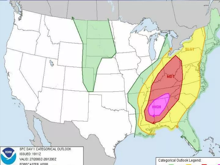
EVENT NOTES - Started 1/24/2012 • 800 Mhz briefing conducted at 2 PM. • HAM radio group has been contacted. • Severe Thunderstorms possible Thursday afternoon and evening. SPC Day 1 Slight Risk covers areas along and south of a line from Detroit to Addison, most of CWA. • Several waves of storms are possible across the forecast area as a sfc low develops and moves northeast across Central Alabama. At this time, the greatest severe threat appears to be in the afternoon and evening hours. The main threats being damaging straight-line winds and localized flooding with isolated tornadoes generally south of I-20. • Tornado Safety PNS sent at 720am...expires at noon...on 20 min periodicy. • Multi-Media Briefing/HWO highlight severe threat.
November 16th 2011 Talking Points Event Synopsis: A warm sector developed across south central Alabama during the morning hours of November 16, 2011. Storms with a history of producing tornadoes across southern Mississippi moved into southwest Alabama shortly after sunrise. The storms produced sporadic damage from the Alabama-Mississippi state line all the way to the Alabama-Georgia state line. SPC had the southern half of Alabama in a slight risk of severe thunderstorms and isolated tornadoes were mentioned in the Day1 outlook issued at 7 am CST 11/16/2011. Known Locations: The following counties reported damage;Sumter, Marengo, Lowndes, Montgomery, Elmore, Macon, Tallapoosa and Lee. Surveys Completed: EF-2 Sumter County…Lead Time 33 minutes. 1 Injury. EF-0 Marengo County…Tornado just outside polygon. Watches: Tornado Watch #887 valid from 200am CST – 1000am CST Tornado Watch #887 extended & expanded until 12 noon CST Tornado Watch #889 valid from 945am CST – 600 pm CST...Lee Co Warnings: 16 Tornado Warnings, 1 Severe Thunderstorm Warning were issued beginning at 634 am through 1225pm. -Tor 166 included Lee County 1148am-storm at Auburn 1207pm -Tor 167 included Lee County 1218pm-storm at state line 1235pm Event Facts: Tornadoes were reported in Mississippi, Louisiana, Texas, Alabama, Georgia, South Carolina, & North Carolina associated with this system. Typical fall season mesoscale forecast difficulties, will CAPE be enough to realize the SRH. In this case, both parameters were higher than forecast.
Talking Points – Continued Lee Co Severe Weather Facts: -Last tornado in Lee County 5/23/09 F0 The weak tornado touched down in northeast Lee County on the south side of Halawaka Creek. Starting just to the west of Forest Road and traveling to the northwest, the tornado lifted after it crossed Lee Road 462 and crossed into the lake. Damage along the path included approximately 150 trees snapped or uprooted, several of which fell onto homes and other buildings, including sheds and boat houses. Rain bands associated with a low pressure system in the northern Gulf of Mexico produced two tornadoes in central Alabama. -Last tornado in Lee County in the fall 11/24/04 F0 National Weather Service Meteorologists surveyed the damage on the outskirts of Opelika. The brief touch down and minor damage was the result of a weak tornado. The tornado has been rated an F0. Additional damage across Lee County was due to straight line winds. A very brief tornado touched down on the far southeast side of Opelika, east of SR 169. Several structures received minor damage. A few trees and power lines were also blown down. The tornado damage path was 0.25 miles long and 30 yards wide at its widest point. The tornado was on the ground at 809 am CST and lifted within one minute. -Strongest tornado documented in Lee County F3… 4/18/53 – Near Auburn, At least 50 homes were destroyed. 4 people died near Smiths in a small home. One person died near Phenix City. 12/5/54 - 2 N Opelika, 11 homes destroyed, 64 homes damaged, 33 other buildings damaged, and chicken farm heavily damaged. -Lee County has had 21 documented tornadoes since 1950
Daily email summary to staff and HQ My thanks to everyone for an outstanding job for an historic event. I have nothing but extreme kudos for our work during this event. For the second time in a couple of weeks, Jim Cantore (TWC) has specifically stated our graphicasts are the best he sees across the NWS and he uses them often. As far as where we stand, here is a quick summary. Tom Bradshaw is flying in Thursday night and will working out of our office for a few days. Since we are "ground zero", he will be feeding NWSHQ information directly, trying to help alleviate us doing the work. Two forecasters will be working shifts. Camp Parks, TLH, will work day shifts over the next few days (beginning with a K on Fri). KrissyScotten will be working midnights, beginning Saturday morning. This will allow us some flexibility for us to do surveys. Tim Marshall, who is used extensively by the NWS across the country for survey ratings of violent tornadoes, will be arriving at the office tomorrow morning and we will develop a game plan on the fly. John will be the post-event coordinator for the event and is setting up the teams for additional surveys. As far as media requests, I have attached talking points. Jody will post these on the WIKI page and let you know where they are located. They will be amended as new information occurs. You are welcome to give media interviews, but please do not stray from these talking points to keep everyone on the same page. If unsure, tell them to call tomorrow, or give them my GOVERNMENT cell number.
Summary ~88 % of all tornadoes EF0-1, ~11% are EF2-3 Most tornadoes are survivable “if” there are properly constructed shelters and actions taken This was a very rare, historic event, BUT… IT’S NOT A QUESTION “IF” IT WILL HAPPEN AGAIN, IT’S “WHEN” AND “WHERE”


![The Importance of Being Earnest [in Security Warnings]](https://cdn1.slideserve.com/1766329/the-importance-of-being-earnest-in-security-warnings-dt.jpg)