Download
1 / 31
310 likes | 529 Views
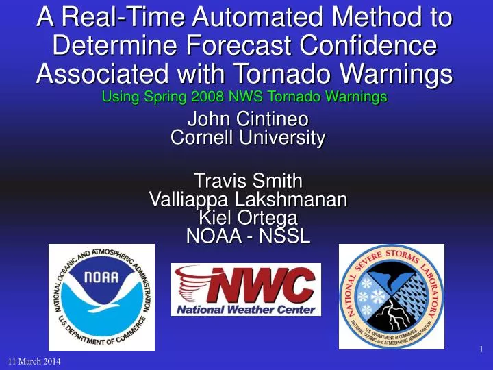
John Cintineo Cornell University Travis Smith Valliappa Lakshmanan Kiel Ortega NOAA - NSSL. A Real-Time Automated Method to Determine Forecast Confidence Associated with Tornado Warnings Using Spring 2008 NWS Tornado Warnings. Background.

E N D
John Cintineo Cornell University Travis Smith Valliappa Lakshmanan Kiel Ortega NOAA - NSSL A Real-Time Automated Method to Determine Forecast Confidence Associated with Tornado WarningsUsing Spring 2008 NWS Tornado Warnings
Background • Warning Decision Support System – Integrated Information (WDSS-II) • Uses merged, multi-sensor CONUS radar network • combines model, lightning, and GOES satellite data • Short-term severe weather forecasting products • Objective: • To examine how WDSS-II products can be used as predictors for issuing NWS tornado warnings. • Assign objective probabilities to warnings based on varying the attribute threshold.
Environmental Shear Storm Relative Flow 9-11km AGL Storm Relative Helicity 0-3km CAPE, CIN LCL min height SATELLITE: IR band-4 min temp. (cloud tops) Total of 23 products Radar-derived productsStorm Environment Data • Maximum Expected Size of Hail (MESH) • Probability of Severe Hail (POSH) • Severe Hail Index (SHI) • Vertically Integrated Liquid (VIL) • Area of VIL +30 • Echo Tops of 50, 30, & 18dBZ • 3-6 km & 0-2 km Azimuthal Shear • Lowest level max dBZ • Reflectivity at 0C, -10C, & -20C • Overall max reflectivity • Height of 50dBZ above 253K isotherm
Methodology: • Investigated archived NWS spring 2008 CONUS tornado warnings with WDSS-II radar-derived products • Each storm attribute maximum (or minimum) values computed every 1 minute of the warning • Compared attribute values from the issuance of the warning (initial values) and the expiration of the warning (lifetime max/min). • Composite time series of each attribute • Warnings broken down by verified vs. unverified • Verification data obtained from the Storm Prediction Center’s storm data (preliminary). • storm environment data provided by 20-km RUC model.
Dataset: • 2 May – 1 July for 0-2 km Azimuthal shear, VIL, Area of VIL +30, and reflectivity products • 15 May to 1 July for 3-6 km Azimuthal shear • 20 random days for Storm Environment attributes • NB: for 1 May – 10 May 0-2 km Azimuthal shear is replaced by 0-3km Azimuthal shear 1,617 Tornado WarningsFrequency of Hits = 0.256 (414 verified warnings)False Alarm Ratio = 0.744 (1,203 unverified warnings)Average Warning Duration: 38.6 mins
Initial 0-2 km Azimuthal Shear UNVERIFIED VERIFIED Mean: 0.0053 s^-1 Mean: 0.0078 s^-1 SD: 0.0044 s^-1 SD: 0.0053 s^-1
Lifetime Max 0-2km Azimuthal Shear UNVERIFIED VERIFIED Mean: 0.0078 s^-1 Mean: 0.0109 s^-1 SD: 0.0051 s^-1 SD: 0.0055 s^-1
Probability that a warning verified, given an initial 0-2 km Az. Shear
Initial Vertically Integrated Liquid (VIL) UNVERIFIED VERIFIED Mean: 27.76 kg/m^2 Mean: 34.44 kg/m^2 SD: 20.46 kg/m^2 SD: 18.66 kg/m^2
Lifetime Maximum VIL UNVERIFIED VERIFIED Mean: 37.00 kg/m^2 Mean: 46.35 kg/m^2 SD: 20.27 kg/m^2 SD: 18.05 kg/m^2
Probability that a warning verified, given an initial Vertically Integrated Liquid
Initial Vertically Integrated Liquid (kg/m^2) y >= 60 60 > y >= 40 40 > y >= 20 y < 20 CONDITIONAL PROBABILITY CONTINGENCY TABLE Initial 0-2 km Az. Shear (s^-1) x < 0.004 0.004 <= x < 0.008 0.008 <= x < 0.012 x >= 0.012
Summary • Provide warning guidance for the NWS • Once a NWS tornado warning is issued, WDSS-II can automatically assign a probability that it will verify, in real-time • More years of warning data will lead to a better climatology of warning probabilities • With more warning data, create a contingency table based on 3 or 4 of the best predictors • Forecasters can use such probability data to reduce their FAR
Future avenues of research • Extend the data set to include past springs • Examine environment just outside the warning polygons (to capture the entire storm) • Compare spring and fall tornado warnings • Compare attributes in tornado and severe T-storm warnings • Compare warning data based on region • Investigate warnings issued in watches, and those outside of watches
Summary • Provide warning guidance for the NWS • Once a NWS tornado warning is issued, WDSS-II can automatically assign a probability that it will verify, in real-time • More years of warning data will lead to a better climatology of warning probabilities • With more warning data, create a contingency table based on 3 or 4 of the best predictors • Forecasters can use such probability data to reduce their FAR
Acknowledgements • Travis Smith • Lak • Kiel Ortega • Owen Shieh • This research was supported by an appointment to theNational Oceanic and Atmospheric AdministrationResearch Participation Program through a grant award to Oak Ridge Institute for Science and Education.
References • Erickson, S. A., Brooks, H., 2006: Lead time and time under tornado warnings: 1986-2004. 23rd Conference on Severe Local Storms • Guillot, E., T. M. Smith, Lakshmanan, V., Elmore, K. L., Burgess, D. W., Stumpf, G. J., 2007: Tornado and Severe Thunderstorm Warning Forecast Skill and its Relationship to Storm Type. • Lakshmanan, V., T. M. Smith, K. Cooper, J. J. Levit, G. J. Stumpf, and D. R. Bright, 2006: High-resolution radar data and products over the Continental United States. 22nd Conference on Interactive Information Processing Systems, Atlanta, Amer. Meteor. Soc. • Lakshmanan, V., T. Smith, K. Hondl, G. J. Stumpf, and A. Witt, 2006: A real-time, three dimensional, rapidly updating, heterogeneous radar merger technique for reflectivity, velocity and derived products. Weather and Forecasting 21, 802-823. • Lakshmanan, V., T. Smith, G. J. Stumpf, and K. Hondl, 2007: The warning decision support system - integrated information (WDSS-II). Weather and Forecasting 22, 592-608. • Ortega, K. L, and T. M. Smith, 2006: Verification of multi-sensor, multi-radar hail diagnosis techniques. 1st Severe Local Storms Special Symposium, Atlanta, GA, Amer. Meteo. Soc. • Ortega, K. L., T. M. Smith, G. J. Stumpf, J. Hocker, and L. López, 2005: A comparison of multi-sensor hail diagnosis techniques. 21st Conference on Interactive Information Processing Systems (IIPS) for Meteorology, Oceanography, and Hydrology, Amer. Meteo. Soc., P1.11 - CD preprints. • Witt, A., Eilts, M., Stumpf, G. J., Johnson, J. T., Mitchell, D. E., Thomas, K. W., 1998: An Enhanced Hail Detection Algorithm for the WSR-88D.
Initial 3-6 km Azimuthal Shear UNVERIFIED VERIFIED Mean: 0.0054 s^-1 Mean: 0.0076 s^-1 SD: 0.0041 s^-1 SD: 0.0046 s^-1
Lifetime Max 3-6 km Azimuthal Shear UNVERIFIED VERIFIED Mean: 0.0084 s^-1 Mean: 0.0112 s^-1 SD: 0.0049 s^-1 SD: 0.0052 s^-1
Probability that a warning verified, given an initial 3-6 km Az. Shear
Initial Max LL Reflectivity Mean: 49.88 dBZ Mean: 55.09 dBZ SD: 14.63 dBZ SD: 11.02 dBZ
Lifetime Max LL Reflectivity Mean: 56.86 dBZ Mean: 60.51 dBZ SD: 10.39 dBZ SD: 7.11 dBZ
Initial dBZ @ -20C Mean: 46.58 dBZ Mean: 53.08 dBZ SD: 14.21 dBZ SD: 10.78 dBZ
Lifetime Max dBZ @ 20C Mean: 52.75 dBZ Mean: 57.86 dBZ SD: 11.97 dBZ SD: 8.43 dBZ
Probability a warning verified, given a certain Az. shear 0-2km Az. Shear3-6km Az. Shear