Download
1 / 1
10 likes | 159 Views
Joint Polar Satellite System (JPSS) Common Ground System (CGS) Environmental Products Kerry Grant, JPSS CGS Chief Scientist Raytheon Intelligence and Information Systems, Aurora CO Robert Hughes, Deputy IPT Lead, Algorithms and Data Products Nancy Andreas, NPOESS System Performance Lead

E N D
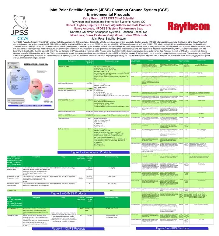
Joint Polar Satellite System (JPSS) Common Ground System (CGS) Environmental Products Kerry Grant, JPSS CGS Chief Scientist Raytheon Intelligence and Information Systems, Aurora CO Robert Hughes, Deputy IPT Lead, Algorithms and Data Products Nancy Andreas, NPOESS System Performance Lead Northrop Grumman Aerospace Systems, Redondo Beach, CA Mike Haas, Frank Eastman, Gary Mineart, Jane Whitcomb Joint Polar Satellite System The NPOESS Preparatory Project (NPP) and JPSS-1 constitute the first two satellites in the JPSS constellation. Both satellites will fly the same sensor suite, and will generate the data from which the JPSS CGS will produce 25 Environmental Data Records (EDRs - Figure 1) from the 4 separate instruments flying on the spacecraft (VIIRS, CrIS, ATMS, and OMPS). Note that the EDRs for one instrument, CERES, are not produced by CGS. NPP launched successfully on October 28, 2011. CGS will also produce EDRs for two additional missions, the Global Climate Observation Mission – Water (GCOM-W), and the Defense Weather Satellite System (DWSS). GCOM-W will fly one instrument, the AMSR-2 microwave imager, and DWSS will fly three instruments, including the same VIIRS now flying on NPP. The 25 products from NPP and JPSS-1 shwn, here, along with their associated Sensor Data Records (SDRs) and several Intermediate Products (IPs) are delivered to several government processing centers for operational use, and, most importantly for the general research community, to NOAA’s Comprehensive Large Array-data Stewardship System (CLASS). CLASS is responsible for archiving and distributing all NPP data products to the general public. Products sent to CLASS from the CGS data processing system (known as the Interface Data Processing Segment, or IDPS) will be aggregated into 5 minute granules to provide for efficient transport and archival. The information presented here will help users prepare for the upcoming release of operational NPP products (and ultimately, JPSS-1 products), in terms of volume, coverage, and measurement range. The geolocation products (Figure 2) may be packaged separately or combined with the delivered products, depending upon the request method. Environmental Products are grouped by sensor (Figures 3 – 5) and a description of the product itself, its anticipated use, its size based on the actual non-aggregated data granule, coverage, and measurement range is provided. Figure 1 NPP Environmental Data Records - - Figure 1 - - NPP Environmental Data Records Figure 2 – Geolocation Products Figure 3 – CrIMSS Products Figure 5 – VIIRS Products Figure 4 – OMPS Products