Download
1 / 1
10 likes | 118 Views
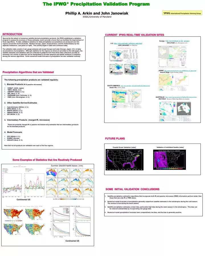
The IPWG* Precipitation Validation Program Phillip A. Arkin and John Janowiak ESSIC/University of Maryland. *IPWG : International Precipitation Working Group. Europe http://kermit.bham.ac.uk/~ipwgeu/ Chris Kidd (Univ. Birmingham, U. K.). too little rain. too much rain.

E N D
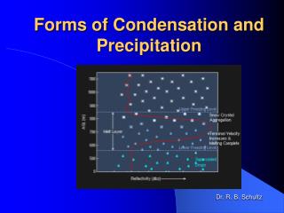
The IPWG* Precipitation Validation Program Phillip A. Arkin and John Janowiak ESSIC/University of Maryland *IPWG: International Precipitation Working Group Europe http://kermit.bham.ac.uk/~ipwgeu/ Chris Kidd(Univ. Birmingham, U. K.) too little rain too much rain U.S. http://cics.umd.edu/~johnj/us_web.html John Janowiak(Univ. Maryland) JAPAN http://www-ipwg.kugi.kyoto-u.ac.jp/IPWG/sat_val_Japan.html Shoichi Shige (Kyoto University, JAPAN) SOUTH AMERICA http://cics.umd.edu/~dvila/web/SatRainVal/dailyval.html Daniel Vila(CPTEC, Brasil) Summer (Dec08-Feb09) biases (mm) AUSTRALIA http://cawcr.gov.au/projects/SatRainVal/dailyval.html Beth Ebert (Bureau of Meteorology, Melbourne, Australia) INTRODUCTION CURRENT IPWG REAL-TIME VALIDATION SITES Spurred by the advent of numerous satellite-derived precipitation products, the IPWG established a validation program to assess the accuracy of those estimates, and to provide a forum that can facilitate the improvement of those algorithms. To date, validation statistics for daily precipitation accumulations are produced over five regions around the world (Australia, Western Europe, Japan, South America, and the United States) by five separate institutions (see panel on right). This activity began in 2003 and continues today. The validation data consist of rain gauge analyses (all except Europe) and radar (Europe, Japan, U.S.) of daily accumulations of precipitation. Although statistics for the regions as whole are provided on the web pages, the satellite estimates and validation data are collected in gridpoint form thus these data collections provide an extremely rich volume of data that can be manipulated to provide temporal and spatial variations of statistics among the various algorithms. Some numerical model forecasts of precipitation are also validated routinely. Precipitation Algorithms that are Validated • The following precipitation products are validated regularly: • 1. Blended Products (IR & passive microwave) • GSMaP (JAXA, Japan) • TMPA (NASA, U.S.) • CMORPH (NOAA, U. S.) • NRL (Navy, U. S.) • PERSIANN (Univ. Cal-Irvine, U. S.) • PMIR (Univ. Birmingham, U. K.) • Other Satellite-Derived Estimates • HydroEstimator (NOAA, U. S.) • MiRS (NOAA, U. S.) • MSPPS (NOAA, U. S.) • GMSRA (NOAA, U. S.) • GPI (NOAA, U. S.) • Intermediary Products (merged IR, microwave) These are primarily merged IR or passive microwave-only estimates that are intermediary products for the blended products. • Model Forecasts • GFS (NOAA, U. S.) • ECMWF (Europe) • NOGAPS (Navy, U. S.) Note that not all products are validated over each of the five regions. FUTURE PLANS Coastal Ocean Validation (radar) Validation of individual Swaths (radar) Some Examples of Statistics that Are Routinely Produced SOME INITIAL VALIDATION CONCLUSIONS • Satellite precipitation estimation algorithms that incorporate both IR and passive microwave (PMW) information perform better than • those that use only IR or PMW alone; • Numerical model forecasts of precipitation generally outperform satellite estimates in the extratropics during the cold season. • The reverse is true during the warm season. • Satellite precipitation estimates contain bias, particularly high bias during the warm season in the extratropics. This bias can • be reduced substantially by incorporating rain gauge data. • Numerical model precipitation forecasts have comparatively low bias, and the bias is generally positive. Continental US Continental US