Download

1 / 61
630 likes | 976 Views
Surface Water. Earth Science- Chapter 13 Mr. Hendricks and Mr. McMahon. Chapter Outline. Streams and River Erosion and Deposition River Valleys Floodplains and Floods. Streams and Rivers. River Systems Vocabulary - Continental Divide: - Water Shed aka Drainage Basin: - River system

E N D
Surface Water Earth Science- Chapter 13 Mr. Hendricks and Mr. McMahon
Chapter Outline Streams and River Erosion and Deposition River Valleys Floodplains and Floods
Streams and Rivers River Systems Vocabulary - Continental Divide: - Water Shed aka Drainage Basin: - River system - Tributary
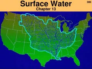
River System Definition- A river and all of its tributaries (feeder river or connecting rivers) Example: Mississippi River System
Drainage Basin or Watershed Drainage Basin or Watershedall is all the land that drains into the river directly or through it’s tributaries. Example: green area is Mississippi R. Basin
Continental Divide Defined as the highland that separates one drainage basin from another. Usually a mountain range Sub-Continental divide in Men. Falls
Tributary • A tributary is a feeder river/ creek/ stream that flows into a large parent river. • There are some 250 tributaries of the Mississippi which drain a total area of more than 1,247,000 square miles--one third of the nation's landmass!
River Characteristics Channelized flow- water flows in a chanel Velocity- how fast a river is flowing Gradient- how steep a river is Discharge- how much water is flowing
Velocity How fast something is moving High velocity = high speed Low velocity = low speed
Channelized Flow Cross section of river displaying channelized flow Rivers are “Confined” by their channel Affects Velocity of water
Gradient Slope of a stream Rise over Run A river may drop 10 feet over a distance of 100 feet Gradient is 1/10 or 10%
Discharge Cross Sectional Area = Width * Depth 5 ft * 100 ft = 500 ft2 Velocity = 1 foot / second Discharge = 500 ft2 * 1 ft/sec = 500 ft3 / second
Discharge Volume of water that passes a point over an amount of time How much water is flowing in a river Cross sectional area * Velocity
How to determine discharge Discharge = Cross sectional area * Velocity Determine the discharge of a stream with the following characteristics: Confined by two vertical walls. The average depth of water is 5 feet. The channel is 100 feet wide Average velocity = 1 foot per second
Discharge Discharge is not constant. Depends on conditions Increased down river Increased during times of high precipitation or melt Spring = High Discharge
Erosion and Deposition How does it happen? Mechanical Weathering- Abrasion Running water What does it produce? Sediment Rounded rocks Potholes
Erosion, Transport, and Deposition • Whether sediment is being eroded, transported, or deposited depends on the size of the particle and velocity of water • Hjulstrom Curve
Transportation of Sediment Load: material transported by river Bedload: moved along bottom, rocks, gravel, pebbles Suspension: clay- silt muddy water Solution: material dissolved in water Capacity: total amount of sediment a stream can carry Competence: Maximize size particles a steram can carry
Deposition Sediment is deposited when the velocity of the current can no longer transport material Examples: A boulder will not be transported by a trickling crick A rapid river will move particles of all sizes because of the high V Silt and Clay is deposited in the deep ocean because there is barely a current (low V)
Depositional Feautres Delta Sandbars Deposit Bank
Delta A fan-shaped deposit that forms when a river flows into a quiet or large body of water Where do you think clay particles are deposited on the diagram?
Sand Bars Wisconsin River- How do they form? -Discuss for 2 mins
Sand Bar Formation Current carries sediment Sediment is deposited when current is slowed down Sediment begins to pile up and catch more sediment Bars constantly move to change in current and water depth
River Valleys Toad River, Canada
Why do some rivers grow so big? All rivers start on a small scale Rainstorm forms a valley in loose soils called a gullie Rainstorm ends, water evaporates, but depression remains Next rainstorm, erosion continues As time goes on, a gullie increases length, width, and depth Continuous erosion of land
Headward Erosion The process by which land is worn away at the head of a stream or gully Head: An abrupt drop in elevation Waterfall Erosion opposite the direction of waterflow
Canyons • Canyon- river valley with steep vertical sides • Form in areas with low rainfall • Factors in formation: Type of rock, amount of water, climate • Colorado R. -Grand Canyon)
V-Shaped Valleys • Rain erodes the sides of a valley which forms a V shape • Deeper channel = greater width • Ex: Yellowstone River
Base Level • Streams can’t cut any deeper than the body of water they flow into • Ultimately, all rivers only can cut to sea level
Rapids and Waterfalls Water flowing over a cliff or steep, jagged slope forms rapids and waterfalls High rate of erosion at Rapids and WF Undermining Temporary features
Undermining • 1) Waterfall creates pool • 2) Undercuts the waterfall • 3) Creates overhang • 4) Overhang collapses • 5) Recession upstream
Floodsplains and Floods • Features of a Floodplain: • Meanders • Oxbow Lake • Natural Levees
Floodplain Features • Meander-River winding back and forth with broad curves
Features • Oxbow Lake- A curved body of water that separates a meander from its river • Formed due to erosion of river banks
Floodplain Feature • Natural Levee- thick deposits alongside stream banks • Elevated ridges
Floods • Naturally occurring event after heavy or long-lasting rains • Positive and Negative Effects • Recent Flooding?
Flood Effects • Positive • Negative • Relieve water and sediment overload of the channel • Floods deposit minerals on floodplains making these areas fertile for agriculture • Destructive for people near rivers • Cause damage to buildings, farmland, and other properties • Dangerous water levels/velocity
Flood Causes • For large rivers, like the Mississippi, floods occur after many days of heavy, steady rainfall- No flash floods • Spring melt • Dam failures- Ex: Lake Delton