Download

1 / 22
220 likes | 332 Views
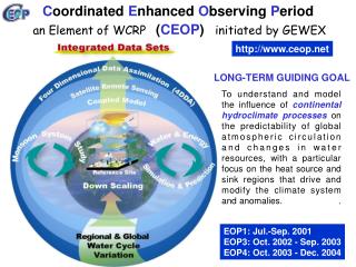
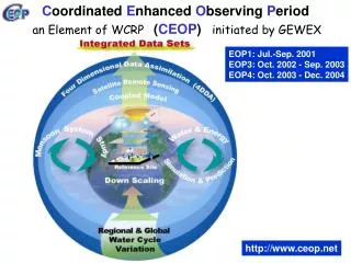
C oordinated E nhanced O bserving P eriod. CEOP HP : http://www.ceop.net. Toshio Koike, Petra Koudelova ( University of Tokyo ), Sam Benedict, Steve Williams ( NCAR/EOL ) 3 rd IGOS-Cryosphere Theme Workshop, Noordwijk, 16 – 18 October 2006. LONG-TERM GUIDING GOAL To understand and model

E N D
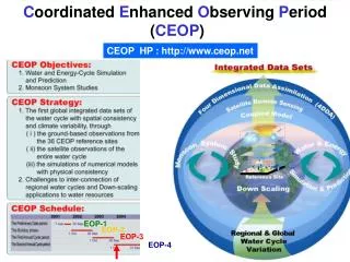
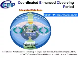
Coordinated Enhanced Observing Period CEOP HP : http://www.ceop.net Toshio Koike, Petra Koudelova (University of Tokyo), Sam Benedict, Steve Williams (NCAR/EOL) 3rd IGOS-Cryosphere Theme Workshop, Noordwijk, 16 – 18 October 2006
LONG-TERM GUIDING GOAL To understand and model the influence of continental hydroclimate processes on the predictability of global atmospheric circulation and changes in water resources, with a particular focus on the heat source and sink regions that drive and modify the climate system and anomalies. • Integrated global dataset: • in-situ observation (35 reference sites) • satellite products • model output c Coordinated in time and space; Consistent format compatible with ISO standards; Good accessibility
EOP1: Prelim. p. (Jul-Sep 2001) EOP3: 1st annual cycle (Oct2002 – Sep2003) EOP4: 2nd annual cycle (Oct2003 – Dec2004) CEOP Timeline Year ‘99 ‘00 ‘01 ‘02 ‘03 ‘04 ‘05 ‘06 ‘07 ‘08 ‘09 ‘10 Phase 1 Phase 2 CEOP Activities Preparations Data Collection EOP2: Build-up (Oct2001 – Sep2002) Phase 2 observing p. (Jan2007 – Dec2010) Data Management Research Activities
In-situ observation data: 35 reference sites over the globe Satellite observation data: • ADEOS-II:GLI(Radiance, Precipitable water, SST, Snow grain size, Aerosol optical thickness, Cloud parameters, Cloud liquid water,1km surface reflectance, Vegetation index),AMSR(like AQUA AMSR-E) • AQUA: AMSR-E(Brightness temp., Soil moisture, Snow water equivalent, Rain rate, Water vapor, Cloud liquid w., SST, Sea surface wind speed), AIRS, MODIS • DMSP: SSM/I(Brightness temperature) • GMS-5: VISSR(Brightness temperature, Albedo) • GOES-9: VISSR(Brightness temperature, Albedo) • ENVISAT: ASAR(Medium resolution image, precise image, geocoded image), MERIS(TOA radiance, Cloud and Water vapour, Vegetation indices), • NOAA: AVHRR • TERRA: MODIS • TRMM: TMI(Brightness temp., Rain rate profile, Surface rain), PR(Rain rate profile, Surface rain) • Global fields • Five monsoon regions subsets • 250x250 km subsets around reference sites Model output data: Currently 12 contributing NWP and Data assimilation Centers:BMRC(Australia),CPTEC (Brazil), ECMWF (Europe), ECPC (USA), JMA (Japan), MSC (Canada), NASA-GLDAS, NASA-GMAO, NCEP (USA), NCMRWF (India), UKMO (UK) ,EPSON Meteo(Italy – will contribute to Phase 2) • Analysis/Assimilation & Forecast products Globalgridded model output & MOLTS– (Model Output Location Time Series) at reference site locations • Operational&Reanalysissystem products;Global &RegionalNWP systems
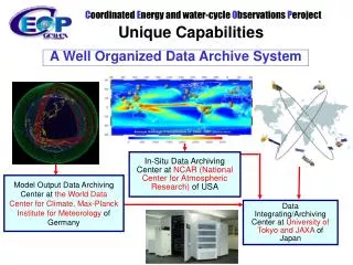
In-Situ Data Archiving Center at NCAR (National Center for Atmospheric Research) of USA Model Output Data Archiving Center at the World Data Center for Climate,Max-Planck Institute for Meteorologyof Germany Data Integrating/Archiving Center at University of Tokyo and JAXAof Japan • A well organized archiving system data collecting, processing, storing, and disseminating • ! Data sharing policy • ! Metadata standard - ISOTC/211 19115
http://www.eol.ucar.edu/ projects/ceop/dm/ INTEGRATED IN-SITU SATELLITE MODEL EOL work supported by NOAA/CPO
Distributed Integration Services NCAR GrADS/ DODS for Subsets Computing Power In-situ Centralized Integration Services GrADS/ DODS for Subsets model In-situ model In-situ model http://jaxa.ceos.org/wtf_ceop/ MPI http://monsoon.t.u-tokyo.ac.jp/ceop-dc/ceop-dc_top.htm GrADS/ DODS for Subsets satellite satellite satellite Computing Power UT/JAXA Distributed Data Integration System available on-linesince June 2005 Centralized Data Integration Systemavailable on-linesince June 2005
Possible Steps for Expanding the CEOP System to Accommodate Cryosphere Data and Products • To include into the CEOP database observations from existing reference sites/basins in cold regions (Arctic/Antarctic) • To include further cryosphere satellite products into the CEOP database • To include cryosphere-related model output into the CEOP database; identify further variables (if any) that need to be stored • To accommodate “special-format” cryosphere data and products (glaciers, permafrost, sea ice…) – need to discuss with the data management group the format and the way how to include these types of data workshop
CEOP-CliC Collaboration • CEOP Phase 2 – Cold region study:To diagnose, simulate and predict water and energy fluxes and reservoirs in cold regions on diurnal to annual temporal scales as well as apply these predictions for water resource applications based on the enhanced observations and the tools and techniques already established by CliC and CEOP. • CEOP-CliC proposal for IPY: • Convergence of Observation and Data Integration (Reference site/basin network in cryosphere; Integrated satellite products in cold region) • Long-term Variation of Snow Distribution in the Northern High Latitude Region and Its Impacts on Atmospheric Circulation (Seasonal and Inter-annual Variation of Land Hydrological Conditions – using satellite products validated by in-situ observations) • Water and Energy Budgets (WEBs) (Whatcomponents of the water and energy cycles in northern latitudes can be observed, and how well they can be simulated;Impactsof the WEB variation on the atmospheric circulation;Intercomparison among the large river basins facing to Arctic Sea) • High Mountain Hydrology Including Glacier (From process study to application to water resources management)
1. Convergence of Observation and Data Integration • Targets: • ・Reference site/basin network in cryosphere • ・Integrated satellite products in cold region • Strategy: • (1) Sophistically integrated in-situ observation (super site/basin) including isotope, streamflow: new site involvement through focusing location, number, standard. • (2) Common metadata and data policy (Interoperability) (ISO19115; Link CEOP Data to DISC; Shared Archives, Buoys, field project data, Satellite data/products) • (3) Data quality check (CEOP standards; Solid precipitation questionnaire for reference sites) • (4) Integrated satellite products validated by in-situ data: snow, snowfall, soil moisture, canopy snow, (vegetation) • (5) Precipitation data applying various methods
CEOP Reference Site in the Cold Regions
In-situ Data Archive http://www.eol.ucar.edu/projects/ceop/dm/ REFERENCE SITE DESCRIPTION • 1D site: Near surface +surface + sub-surface; atmospheric sounding (radiosonde, wind profile, LIDAR, microwave rain radar) is highly desirable • 2D site: A few 1D sites + surface heterogeneity with an area 100 km2 • 3D site: 1D sites network (+3D system) or 2.5 site + 3D atmosphere (Doppler radar, cloud radar, aerosonde aircraft) with an area 104 km2 • Sub-surface (0 to -1m): soil moisture and temperature profile, heat conduction, soil characteristics • Surface(0 to +2m): 4-component radiation, PAR, surface temperature, surface soil moisture, precipitation, vegetation type characteristics, snow • Near surface(+2 to +10m): temperature, specific humidity and wind speed profiles, surface pressure, momentum, latent and sensible heat fluxes
Reference Site Metadata Individual Site Metadata includes: • Station (s) • Contact (s) • Links to relevant web pages • Station location (e.g. maps, photos) • Station description (e.g. vegetation characteristics, soil types, climate) • Parameters and Instrumentation descriptions (SFC, TWR, STM, FLX, UA) • Links to presentations • Links to data sets and additional documentation
CEOP Reference Sites Data Release Guidelines Data exchange guidelines: • To comply with WMO Resolutions 40 (CG-XII) and 25 (CG- XIII) in particular: No financial implications. (2) CDA and data users: Commercial exploitation of CEOP data is prohibited. (3) Data users: No transfer to third parties. (4) Data release to data users: Turn-around period. Category 1 data: 6 months Category 2 data: 15 months (5) Acknowledgement and citation (6) Co-Authorship for Reference Sites’ PIs recommended, collaboration base required if PI requests co-authorship (in particular for category 2 data) (7) CEOP Publication Library at CDA
CEOP Reference Sites Data Release Guidelines CEOP Reference Site Data Categories: Standard Data (Category 1):Common or low exploitation value, measurement technology common, generally well understood. Enhanced or Experimental Data (Category 2):High exploitation value, measurement technology sophisticated and/or of experimental nature, contact to PIs highly recommended. Data providers decide on category division of their data !
Reference Site EOP-3/4 Data Flow Data Source Data/Doc Arrive at EOL Apply Auto/Manual Data/Doc Consistency Checks Generate Flagging and Site Statistics Gross Limit Checks Format Verification Data/Flag/Doc Checks Exact/Inexact Dup Records Visual Inspection of Data and Plots EOL Updates Status Table and Detailed Notes Merge Data Available On-Line
CEOP Phase I Reference Site Data Set Availability (as of 6 October) Complete Partial SG = Streamgauge PR = Precipitation
Contacting Data Sources • Subsetting Data Sets • Need to reformat into CEOP • format
CAMP Reference Sites for Phase 2 New Reference site
CEOP Phase II – Reference sites Major continental gaps in current site coverage The Ocean ?
Reference Site Data Set Procedures Report(Approved by the SSC on 29 July 2003) • Introduction • Data Set Description, submission schedule, formats • Metadata • Gap filling • Quality Control/Quality Assurance • File naming convention • Submission instructions to CDA • CDA Composite formation • CDA Quality Assurance • Rawinsonde Data Sets • Ancillary Data Sets