Download
1 / 53
530 likes | 717 Views
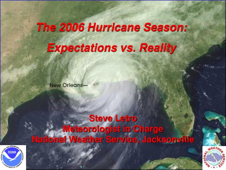
The 2006 Hurricane Season: Expectations vs. Reality. Steve Letro Meteorologist in Charge National Weather Service, Jacksonville. United States Coastal Communities Probably Entered the 2006 Hurricane Season With An Unprecedented Level Of Apprehension and Anxiety….

E N D
The 2006 Hurricane Season: Expectations vs. Reality Steve Letro Meteorologist in Charge National Weather Service, Jacksonville
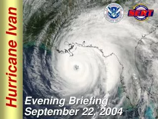
United States Coastal Communities Probably Entered the 2006 Hurricane Season With An Unprecedented Level Of Apprehension and Anxiety… Based on the Previous Two Seasons And Anticipated Conditions…There Was Ample Reason For This Concern!
To Say 2004 and 2005 Were Two “Rough” Seasons Would Be a Gross Understatement! • NAMED STORMS: 43 • HURRICANES: 24 • MAJOR HURRICANES: 13 • U.S. STRIKES 14 • U.S. HURRICANE STRIKES: 9 • MAJOR U.S. HRCN STRIKES 7
Mother Nature Got Our Attention in 2004… • NAMED STORMS: 15 • HURRICANES: 9 • MAJOR HURRICANES: 6 • U.S. STRIKES 6 • U.S. HURRICANE STRIKES: 4 • MAJOR U.S. HRCN STRIKES 3 • Including 4 Hurricane Strikes in Florida!
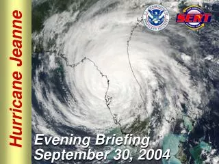
Just When We Thought It Couldn’t Get Any Worse Than 2004:Along Came 2005! • NAMED STORMS: 28* * New Record… Old Record 21 in 1933 • HURRICANES: 15** ** New Record… Old Record 12 in 1969 • MAJOR HURRICANES: 7 • U.S. STRIKES 8 • U.S. HURRICANE STRIKES: 5 • MAJOR U.S. HRCN STRIKES 4
At The Beginning Of The Season There Was Every Reason To Believe 2006 Would See This Unfortunate Trend Continue The Primary Reason: We Are Still In The Active Phase Of A Long Term Cycle Called The Atlantic Multi-Decadal Cycle
Just What Is A “Multi-Decadal Cycle”? • We know that Atlantic Tropical Cyclone frequency varies in distinct 25-40 year cycles • There are negative phases of that cycle when we experience below normal frequencies… • There are also positive phases where frequencies are above normal. • After nearly 30 years of below normal activity we entered a positive phase of the cycle in 1995. • So… how does all this work?
Water cools, sinks, and flows southward Salty, warm shallow water flows northward
MAJOR HURRICANES IN WEAK VS ACTIVE PHASES OF THE MULTIDECADAL CYCLE WEAK ACTIVE
Strong Weak Strong Phase of Thermohaline Circulation
THE RESULT… • The 11 year period between 1995 and 2005 was the most active on record in the Atlantic basin. • In fact… Between 1970 and 1994… no season had more than 3 majors! 1995 -2005 produced 6 seasons with more than 3!
THE BAD NEWS… WE ARE NOW SQUARELY IN THE MIDDLE OF THE “ACTIVE” OR “STRONG” PHASE OF THIS CYCLE!
As A Result, the Early Season 2006 Forecast Looked Grim… • NAMED STORMS: 17 • HURRICANES: 9 • MAJOR HURRICANES: 5 • U.S. STRIKES ? • U.S. HURRICANE STRIKES: ? • MAJOR U.S. HRCN STRIKES ?
The 2006 Season So Far… • NAMED STORMS: 9 • HURRICANES: 5 • MAJOR HURRICANES: 2 • U.S. STRIKES 2 • U.S. HURRICANE STRIKES: 0 • MAJOR U.S. HRCN STRIKES 0 • Only 2 weak tropical storm landfalls!
So What Happened in 2006??? Most Of The Blame (or credit) For The Quieter Season Has Gone To The Unexpectedly Rapid Development of an El Nino Event In The Pacific. So…How Does El Nino Affect Tropical Cyclone Development?
IT STARTS WITH WHICH WAY THE WIND BLOWS… THE IMPORTANCE OF EL NINO • EL NINO PRODUCES WESTERLY WINDS IN THE MIDDLE ATMOSPHERE ACROSS THE TROPICS… CREATING WIND SHEAR WHICH INHIBITS DEVELOPMENT.
SO… JUST HOW DOES EL NINO PRODUCE THOSE WESTERLY WINDS ACROSS THE TROPICS???
THIS HOSTILE ENVIRONMENT HAS SIGNIFICANT EFFECTS ON SEVERAL PARAMETERS: • NUMBER OF HURRICANES • NUMBER OF MAJOR HURRICANES • AREA OF ORIGIN • AREAS AFFECTED
The Statistics Tropical Cyclone Frequency in El Nino vs La Nina Years Phase # Cases Total Storms Hurricanes Strong La Nina 2 10.5 7.5 Mod. La Nina 7 11.1 6.9 Weak La Nina 5 11.4 6.6 Weak El Nino 7 9.6 5.0 Mod. El Nino 10 8.8 4.4 Strong El Nino 4 6.8 3.0
OVERALL THEN… EL NINO TENDS TO PRODUCE: • FEWER OVERALL STORMS • FEWER INTENSE STORMS • FEWER MAJOR STORMS AFFECTING THE UNITED STATES BUT…
Some Facts To Consider… • While This El Nino May Continue To Strengthen, It Was Mainly In The Early Developmental Stage During the Peak of the 2006 Hurricane Season. • The Best Correlations Between El Nino and Decreased Hurricane Activity Usually Occur Once The Event Is Fully Established…which it wasn’t! • This Implies There Were Probably Other Things Going On Besides Just El Nino!
Let’s Take A Look At An Interesting Fact About The 2005 Season… Typically, in very active seasons, the majority of storms develop in the deep tropics… an area called the MDR, or Main Development Region. This was certainly the case in 2004…
2004 Very Active MDR (Main Development Region)
As Busy As the Following 2005 Season Was However… We Began To See An Interesting Change In Atmospheric Conditions Across That Main Development Region
2005 Much less significant MDR Activity!
September 2005… African Dust Blankets Much of the MDR. This continued through much of 2006 This dust is indicative of stable, sinking air… a very unfavorable environment for tropical cyclone development!
The Fact That Significant MDR Activity Did Not Account For The Significant U.S. Landfalls Is Not Really A Surprise… The Fact Is… The storms that ravaged the U.S. Coast in 2005 developed mostly within a few hundred miles of Key Largo!
This Brings Us To Yet Another Important Factor In The Strange (but welcome!) Saga Of the Relatively Benign 2006 Hurricane Season To understand it, we must examine what controls the motion of tropical cyclones
H THE SUMMERTIME ATLANTIC (BERMUDA) HIGH PRESSURE SYSTEM IS PROBABLY THE MOST IMPORTANT FACTOR IN DETERMINING TROPICAL CYCLONE MOTION!
H Tropical cyclones are “steered” westward across the Tropics along the underside of this Atlantic high, before eventually recurving around the western edge.
H H H H H The problem is that the Atlantic High is not constant… either in strength, size or position… and this leads to great differences in the motion of individual tropical cyclones
Climatological Tracks of Atlantic Basin Tropical Cyclones WHEN…AND IF… A TROPICAL CYCLONE RECURVES IS LARGELY A FUNCTION OF THE POSITION AND STRENGTH OF THE BERMUDA HIGH AT ANY GIVEN TIME.
PREVAILING PATTERN 1995 - 2003 H DURING THIS PERIOD, THE ATLANTIC HIGH WAS WEAK AND DISPLACED TO THE EAST. ..
…AS A RESULT, MOST HURRICANES TENDED TO RECURVE WELL EAST OF FLORIDA.
PREVAILING PATTERN 2004 & 2005 DURING THE SUMMER OF 2004… THE PATTERN FINALLY CHANGED… AND THE ATLANTIC HIGH WAS STRONGER AND DISPLACED FURTHER WEST…
…THIS KEPT HURRICANES MOVING FARTHER SOUTH AND WEST… AND RECURVED THEM RIGHT OVER FLORIDA!!!
H THE CHANGE CONTINUED IN 2005 WITH STORMS FORMING AND MOVING FARTHER WEST… WITH EVEN MORE DISASTROUS RESULTS!
Thankfully, 2006 Saw A Return to the 1995-2003 Pattern H This kept storms from forming close to the coast, and kept those farther at sea from approaching.
In Summary… The Benign 2006 Season Was A Result of Several Factors Including: • Dry, stable air over the central and east Atlantic preventing devastating MDR storms from forming. • The development of El Nino… especially affecting latter portions of the season • The return of the deep East Coast trough preventing development in our back yard and tracks that threatened the coast.
WHICH LEAVES US WITH THE BIG QUESTION… Will 2007 Continue The 2006 Trend, or Revert Back To the Devastating Pattern of 2004-2005? …This depends a lot on how persistent and strong the El Nino turns out to be.
Unfortunately, El Nino is not nearly as predictable as we wish it were!