Download
1 / 11
110 likes | 191 Views
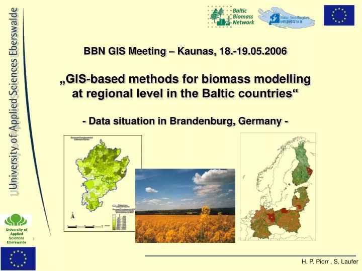
BBN GIS Meeting – Kaunas, 18.-19.05.2006 „GIS-based methods for biomass modelling at regional level in the Baltic countries“ - Data situation in Brandenburg, Germany -. Suitable spatial data sets (digital) in Brandenburg: Administrative units : NUTS 1-4

E N D
BBN GIS Meeting – Kaunas, 18.-19.05.2006„GIS-based methods for biomass modelling at regional level in the Baltic countries“- Data situation in Brandenburg, Germany -
Suitable spatial data sets(digital) in Brandenburg: • Administrative units: NUTS 1-4 • Topographic base maps: ATKIS data sets (relief, water bodies, land cover, urban area, infrastructure, admin. units ...) • Meteorological data: annual precipitation • Relief: Digital terrain model map set • Soil data: general soil maps, yield index (2), soil types of the EU • Land utilisation data: CORINE and ATKIS • Agriculture: digital field register • Forestry: forest stand maps
Examples of available maps • Aministrative units: • Topographic base maps: • Complex map set with various contents/covers (2005) e.g.: • Relief • water bodies • Land cover • Urban area • Infrastructure • Admin. Units • ...
Meteorological data: • 2003 • 1 km raster • Annual average percipitation • Digital terrain model map sets: • 2004, 25m raster • Developed through digitalised contour lines (10m, 5m, 2,5m, 1,25m), peaks and orthophotos
General soil map: • 2004 • Soil classes and types • Aquifer system • Exchange capacity • Yield index • Yield index maps: • Soil evaluation system with 1-100 point scale • Combination of soil and climatic conditions • Digitised Maps of arable land with corresponding yield index (fields + grassland) • 1st: Yield index „Ackerzahlen“ east Germany (1995) • 2nd: Yield index „Ertragsmesszahl“: analog map of soil quality west Germany (1958) • Digitised and combined by University of applied sciences Eberswalde! (2003) Current map 0 - 10 11 - 20 21 - 30 31 - 40 41 - 50 51 - 60 61 - 70 71 - 80 81 - 90 91 - 100 1:2.000.000 1) Ackerzahl 2) Ertragsmesszahl
Soil types of the EU: • Owned by the EEA • Digitised during CORINE project 2000 for western Europe • updated version with central and eastern Europe already exists in the European soil bureau Ispra • CORINE land cover: • Developed in 2000 • land cover / utilisation information • 4 main classes: • Artificial surfaces • Agricultural areas • Forests and semi natural areas • wetlands
2. Suitable statistical data sources in Germany: • Federal statistics • county, state, national level • National forest inventory • Forestry data base (Eastern Germany) • FSS – EU farm structure survey • Eurostat – New Cronos • Eurostat – Eionet
Most important data sources for agriculture: Federal statistics • acreages, yields and total amounts for all crops available • Annually for whole Germany and the federal states (Brandenburg) • But only in a 4 year cycle for counties (NUTS 3) • No access to municipal data confidential! • Most important data sources for Forestry in Brandenburg: Forestry data base of eastern Germany • Very detailed database for every forest stand in Brandenburg • Automatic update • Since 1990 only reliable for state forest because the additional manual update was only performed for state forests
3. Possible cases: • Regional straw potential for a possible ethanol plant in Schwedt, using 800.000 tonnes of straw per year • Wood chip fuelled CHP Plant in Rheinsberg regional potential of forest residues for a sustainable supply from the region • Suitable areas in Brandenburg for short rotation coppice on set aside farmland • ....